![](/images/other/stat-length.png)
![Randonnée Marche Bâgé-Dommartin - DOMMARTIN: Circuit Épaisse - Photo](https://media.geolcdn.com/t/1900/400/ext.pjpeg?maxdim=2&url=https%3A%2F%2Fstatic1.geolcdn.com%2Fsiteimages%2Fupload%2Ffiles%2F1553511878bg_sport_marche.png)
DOMMARTIN: Circuit Épaisse
robertdurand
Utilisateur
![Longueur](/images/other/stat-length.png)
Longueur
16,1 km
![Altitude max](https://static1.geolcdn.com/siteimages/upload/files/1508320355ic_sort_altitude_max_24dp.png)
Altitude max
219 m
![Dénivelé positif](https://static1.geolcdn.com/siteimages/upload/files/1508320355ic_sort_den_pos_24dp.png)
Dénivelé positif
142 m
![Km-Effort](/images/other/stat-length.png)
Km-Effort
18 km
![Altitude min](https://static1.geolcdn.com/siteimages/upload/files/1508320355ic_sort_altitude_min_24dp.png)
Altitude min
187 m
![Dénivelé négatif](https://static1.geolcdn.com/siteimages/upload/files/1508320355ic_sort_den_neg_24dp.png)
Dénivelé négatif
142 m
![Boucle](https://static1.geolcdn.com/siteimages/upload/files/16400158638029165_repeat_loop_refresh_sync_direction_icon.png)
Boucle
Oui
Date de création :
2014-12-10 00:00:00.0
Dernière modification :
2014-12-10 00:00:00.0
![Marche](https://static1.geolcdn.com/sitytour/trail-icons/101.png)
4h08
Difficulté : Moyen
![Scannez ce code QR pour ouvrir la randonnée dans l'application SityTrail](https://capi.geolives.com/qq0zvz2zws4bq2lad0pu/sitytour/trails/165634/qr.png?size=200)
Application GPS de randonnée GRATUITE
À propos
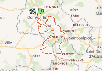
Randonnée Marche de 16,1 km à découvrir à Auvergne-Rhône-Alpes, Ain, Bâgé-Dommartin. Cette randonnée est proposée par robertdurand.
Description
Randonnées au Pays de Bâgé: le Circuit Épaisse vous pemettra de cheminer au cœur du bocage bressan et de ses fermes à pans de bois, puis de longer le domaine de la commanderie des Hospitaliers d'ÉPAISSE.
Localisation
Pays :
France
Région :
Auvergne-Rhône-Alpes
Département/Province :
Ain
Commune :
Bâgé-Dommartin
Localité :
Unknown
Départ:(Dec)
Départ:(UTM)
653061 ; 5133425 (31T) N.
Commentaires
Randonnées à proximité
![Randonnée Marche Chevroux - Chevroux - Photo](https://media.geolcdn.com/t/375/260/ext.jpg?maxdim=2&url=https%3A%2F%2Fstatic1.geolcdn.com%2Fsiteimages%2Fupload%2Ffiles%2F1553511878bg_sport_marche.png)
![Marche Marche](https://static1.geolcdn.com/sitytour/trail-icons/101.png)
Chevroux
Marche
Moyen
Chevroux,
Auvergne-Rhône-Alpes,
Ain,
France
![](/images/other/stat-length.png)
6,7 km | 7,4 km-effort
1h 36min
![](https://static1.geolcdn.com/siteimages/upload/files/16400158638029165_repeat_loop_refresh_sync_direction_icon.png)
Oui
![Randonnée Marche Saint-Sulpice - Ballades des Papilles 2013à St Didier D'Aussiat - Photo](https://media.geolcdn.com/t/375/260/ext.jpg?maxdim=2&url=https%3A%2F%2Fstatic1.geolcdn.com%2Fsiteimages%2Fupload%2Ffiles%2F1553511878bg_sport_marche.png)
![Marche Marche](https://static1.geolcdn.com/sitytour/trail-icons/101.png)
Ballades des Papilles 2013à St Didier D'Aussiat
Marche
Moyen
Saint-Sulpice,
Auvergne-Rhône-Alpes,
Ain,
France
![](/images/other/stat-length.png)
15,7 km | 17,9 km-effort
3h 55min
![](https://static1.geolcdn.com/siteimages/upload/files/16400158638029165_repeat_loop_refresh_sync_direction_icon.png)
Oui
![Randonnée Marche Bâgé-Dommartin - DOMMARTIN: Circuit Épaisse - Photo](https://media.geolcdn.com/t/375/260/ext.jpg?maxdim=2&url=https%3A%2F%2Fstatic1.geolcdn.com%2Fsiteimages%2Fupload%2Ffiles%2F1553511878bg_sport_marche.png)
![Marche Marche](https://static1.geolcdn.com/sitytour/trail-icons/101.png)
DOMMARTIN: Circuit Épaisse
Marche
Moyen
Bâgé-Dommartin,
Auvergne-Rhône-Alpes,
Ain,
France
![](/images/other/stat-length.png)
16,1 km | 18 km-effort
4h 8min
![](https://static1.geolcdn.com/siteimages/upload/files/16400158638029165_repeat_loop_refresh_sync_direction_icon.png)
Oui
![Randonnée Marche Bâgé-Dommartin - Dommartin: le Circuit des Nénuphars - Photo](https://media.geolcdn.com/t/375/260/ext.jpg?maxdim=2&url=https%3A%2F%2Fstatic1.geolcdn.com%2Fsiteimages%2Fupload%2Ffiles%2F1553511878bg_sport_marche.png)
![Marche Marche](https://static1.geolcdn.com/sitytour/trail-icons/101.png)
Dommartin: le Circuit des Nénuphars
Marche
Très facile
Bâgé-Dommartin,
Auvergne-Rhône-Alpes,
Ain,
France
![](/images/other/stat-length.png)
6,5 km | 7,2 km-effort
1h 36min
![](https://static1.geolcdn.com/siteimages/upload/files/16400158638029165_repeat_loop_refresh_sync_direction_icon.png)
Oui
![Randonnée Marche Bâgé-Dommartin - DOMMARTIN: Circuit de la Pérouse - Photo](https://media.geolcdn.com/t/375/260/ext.jpg?maxdim=2&url=https%3A%2F%2Fstatic1.geolcdn.com%2Fsiteimages%2Fupload%2Ffiles%2F1553511878bg_sport_marche.png)
![Marche Marche](https://static1.geolcdn.com/sitytour/trail-icons/101.png)
DOMMARTIN: Circuit de la Pérouse
Marche
Facile
Bâgé-Dommartin,
Auvergne-Rhône-Alpes,
Ain,
France
![](/images/other/stat-length.png)
7,7 km | 8,7 km-effort
1h 55min
![](https://static1.geolcdn.com/siteimages/upload/files/16400158638029165_repeat_loop_refresh_sync_direction_icon.png)
Oui
![Randonnée Marche Bâgé-le-Châtel - Bâgé-la Ville: Pailladières - Photo](https://media.geolcdn.com/t/375/260/ext.jpg?maxdim=2&url=https%3A%2F%2Fstatic1.geolcdn.com%2Fsiteimages%2Fupload%2Ffiles%2F1553511878bg_sport_marche.png)
![Marche Marche](https://static1.geolcdn.com/sitytour/trail-icons/101.png)
Bâgé-la Ville: Pailladières
Marche
Difficile
Bâgé-le-Châtel,
Auvergne-Rhône-Alpes,
Ain,
France
![](/images/other/stat-length.png)
27 km | 30 km-effort
7h 2min
![](https://static1.geolcdn.com/siteimages/upload/files/16400158638029165_repeat_loop_refresh_sync_direction_icon.png)
Oui
![Randonnée Marche Bâgé-le-Châtel - Bâgé-le Chatel: les 3 Châteaux - Photo](https://media.geolcdn.com/t/375/260/ext.jpg?maxdim=2&url=https%3A%2F%2Fstatic1.geolcdn.com%2Fsiteimages%2Fupload%2Ffiles%2F1553511878bg_sport_marche.png)
![Marche Marche](https://static1.geolcdn.com/sitytour/trail-icons/101.png)
Bâgé-le Chatel: les 3 Châteaux
Marche
Facile
Bâgé-le-Châtel,
Auvergne-Rhône-Alpes,
Ain,
France
![](/images/other/stat-length.png)
11,1 km | 12,9 km-effort
2h 30min
![](https://static1.geolcdn.com/siteimages/upload/files/16400158638029165_repeat_loop_refresh_sync_direction_icon.png)
Oui
![Randonnée A pied Chevroux - CHEVROUX - Photo](https://media.geolcdn.com/t/375/260/ext.jpg?maxdim=2&url=https%3A%2F%2Fstatic1.geolcdn.com%2Fsiteimages%2Fupload%2Ffiles%2F1545311037marcheuse_200dpi.jpg)
![A pied A pied](https://static1.geolcdn.com/sitytour/trail-icons/100.png)
CHEVROUX
A pied
Facile
Chevroux,
Auvergne-Rhône-Alpes,
Ain,
France
![](/images/other/stat-length.png)
12,5 km | 13,9 km-effort
3h 9min
![](https://static1.geolcdn.com/siteimages/upload/files/16400158638029165_repeat_loop_refresh_sync_direction_icon.png)
Oui