![](/images/other/stat-length.png)
![Randonnée Vélo Évry-Courcouronnes - Evry et l'eau - Photo](https://media.geolcdn.com/t/1900/400/ext.pjpeg?maxdim=2&url=https%3A%2F%2Fstatic1.geolcdn.com%2Fsiteimages%2Fupload%2Ffiles%2F1524743154velo.jpg)
Evry et l'eau
ouargla
Utilisateur
![Longueur](/images/other/stat-length.png)
Longueur
18,4 km
![Altitude max](https://static1.geolcdn.com/siteimages/upload/files/1508320355ic_sort_altitude_max_24dp.png)
Altitude max
88 m
![Dénivelé positif](https://static1.geolcdn.com/siteimages/upload/files/1508320355ic_sort_den_pos_24dp.png)
Dénivelé positif
183 m
![Km-Effort](/images/other/stat-length.png)
Km-Effort
21 km
![Altitude min](https://static1.geolcdn.com/siteimages/upload/files/1508320355ic_sort_altitude_min_24dp.png)
Altitude min
29 m
![Dénivelé négatif](https://static1.geolcdn.com/siteimages/upload/files/1508320355ic_sort_den_neg_24dp.png)
Dénivelé négatif
185 m
![Boucle](https://static1.geolcdn.com/siteimages/upload/files/16400158638029165_repeat_loop_refresh_sync_direction_icon.png)
Boucle
Oui
Date de création :
2014-12-10 00:00:00.0
Dernière modification :
2014-12-10 00:00:00.0
![Vélo](https://static1.geolcdn.com/sitytour/trail-icons/200.png)
1h12
Difficulté : Très facile
![Scannez ce code QR pour ouvrir la randonnée dans l'application SityTrail](https://capi.geolives.com/qq0zvz2zws4bq2lad0pu/sitytour/trails/164754/qr.png?size=200)
Application GPS de randonnée GRATUITE
À propos
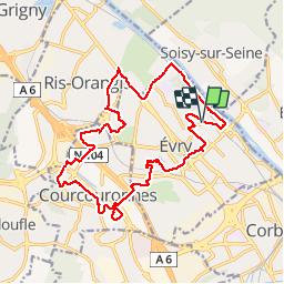
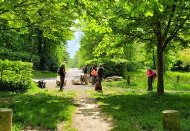
Randonnée Vélo de 18,4 km à découvrir à Île-de-France, Essonne, Évry-Courcouronnes. Cette randonnée est proposée par ouargla.
Description
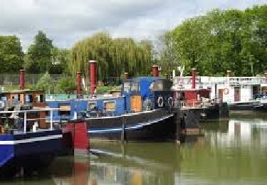
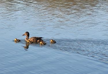
Ballade sympa à vélo sur le thème de l'eau. En effet, nous longeons le lavoir, la préfecture, le lac de Courcouronnes, l"Ecoute s'il pleut" et la Seine.
Localisation
Pays :
France
Région :
Île-de-France
Département/Province :
Essonne
Commune :
Évry-Courcouronnes
Localité :
Évry
Départ:(Dec)
Départ:(UTM)
459191 ; 5387140 (31U) N.
Commentaires
Randonnées à proximité
![Randonnée Marche Étiolles - JC 06 22 km Etiolles Draveil forêt de Sénart - Photo](https://media.geolcdn.com/t/375/260/9c72b108-ab14-460d-9fa7-b7a26e5db3f7.jpg&format=jpg&maxdim=2)
![Marche Marche](https://static1.geolcdn.com/sitytour/trail-icons/101.png)
JC 06 22 km Etiolles Draveil forêt de Sénart
Marche
Très difficile
(1)
Étiolles,
Île-de-France,
Essonne,
France
![](/images/other/stat-length.png)
21 km | 23 km-effort
5h 18min
![](https://static1.geolcdn.com/siteimages/upload/files/16400158638029165_repeat_loop_refresh_sync_direction_icon.png)
Oui
![Randonnée Marche Soisy-sur-Seine - Sénart arbres remarquables 1/2 - Photo](https://media.geolcdn.com/t/375/260/ext.jpg?maxdim=2&url=https%3A%2F%2Fservices.sitytrail.com%2FGeolivesWS%2FDownloadMedia.ashx%3FTrailID%3D672501%26Media%3D4b5c8d28-6a8d-4253-afe1-bf2640671c7d.jpg)
![Marche Marche](https://static1.geolcdn.com/sitytour/trail-icons/101.png)
Sénart arbres remarquables 1/2
Marche
Facile
(1)
Soisy-sur-Seine,
Île-de-France,
Essonne,
France
![](/images/other/stat-length.png)
12,2 km | 13,1 km-effort
2h 55min
![](https://static1.geolcdn.com/siteimages/upload/files/16400158638029165_repeat_loop_refresh_sync_direction_icon.png)
Oui
![Randonnée Marche Tigery - Rando douce 5 Mai - Photo](https://media.geolcdn.com/t/375/260/8aa0ec01-2a07-4fa4-a554-1b183892eea3.jpg&format=jpg&maxdim=2)
![Marche Marche](https://static1.geolcdn.com/sitytour/trail-icons/101.png)
Rando douce 5 Mai
Marche
Moyen
Tigery,
Île-de-France,
Essonne,
France
![](/images/other/stat-length.png)
5,6 km | 6,6 km-effort
1h 54min
![](https://static1.geolcdn.com/siteimages/upload/files/16400158638029165_repeat_loop_refresh_sync_direction_icon.png)
Oui
![Randonnée A pied Étiolles - J 88 Forêt de Sénart, golf d'Etiolles, parc du Grand Veneur - Photo](https://media.geolcdn.com/t/375/260/ext.jpg?maxdim=2&url=https%3A%2F%2Fstatic1.geolcdn.com%2Fsiteimages%2Fupload%2Ffiles%2F1545311037marcheuse_200dpi.jpg)
![A pied A pied](https://static1.geolcdn.com/sitytour/trail-icons/100.png)
J 88 Forêt de Sénart, golf d'Etiolles, parc du Grand Veneur
A pied
Moyen
(2)
Étiolles,
Île-de-France,
Essonne,
France
![](/images/other/stat-length.png)
12 km | 13,6 km-effort
3h 5min
![](https://static1.geolcdn.com/siteimages/upload/files/16400158638029165_repeat_loop_refresh_sync_direction_icon.png)
Oui
![Randonnée Marche Étiolles - JC 75 Arbres remarquables des chasses royales de Sénart - Photo](https://media.geolcdn.com/t/375/260/ext.jpg?maxdim=2&url=https%3A%2F%2Fstatic1.geolcdn.com%2Fsiteimages%2Fupload%2Ffiles%2F1553511878bg_sport_marche.png)
![Marche Marche](https://static1.geolcdn.com/sitytour/trail-icons/101.png)
JC 75 Arbres remarquables des chasses royales de Sénart
Marche
Difficile
(2)
Étiolles,
Île-de-France,
Essonne,
France
![](/images/other/stat-length.png)
23 km | 25 km-effort
5h 46min
![](https://static1.geolcdn.com/siteimages/upload/files/16400158638029165_repeat_loop_refresh_sync_direction_icon.png)
Oui
![Randonnée Marche Saintry-sur-Seine - Boucle 30 km Saintry - Seine Port - Morsang - Photo](https://media.geolcdn.com/t/375/260/147882bb-b6f1-4169-80d4-53a2e8169cea.jpg&format=jpg&maxdim=2)
![Marche Marche](https://static1.geolcdn.com/sitytour/trail-icons/101.png)
Boucle 30 km Saintry - Seine Port - Morsang
Marche
Très facile
Saintry-sur-Seine,
Île-de-France,
Essonne,
France
![](/images/other/stat-length.png)
29 km | 34 km-effort
6h 15min
![](https://static1.geolcdn.com/siteimages/upload/files/16400158638029165_repeat_loop_refresh_sync_direction_icon.png)
Oui
![Randonnée Marche Tigery - Boucle 22 km de Tigery à Soisy via Sénart et bords de Seine - Photo](https://media.geolcdn.com/t/375/260/bab9884f-2ba3-4a3e-a4f4-d1c03b733679.jpg&format=jpg&maxdim=2)
![Marche Marche](https://static1.geolcdn.com/sitytour/trail-icons/101.png)
Boucle 22 km de Tigery à Soisy via Sénart et bords de Seine
Marche
Très facile
Tigery,
Île-de-France,
Essonne,
France
![](/images/other/stat-length.png)
22 km | 25 km-effort
6h 33min
![](https://static1.geolcdn.com/siteimages/upload/files/16400158638029165_repeat_loop_refresh_sync_direction_icon.png)
Oui
![Randonnée A pied Soisy-sur-Seine - L 19 Brunoy forêt de Sénart - Photo](https://media.geolcdn.com/t/375/260/ext.jpg?maxdim=2&url=https%3A%2F%2Fstatic1.geolcdn.com%2Fsiteimages%2Fupload%2Ffiles%2F1545311037marcheuse_200dpi.jpg)
![A pied A pied](https://static1.geolcdn.com/sitytour/trail-icons/100.png)
L 19 Brunoy forêt de Sénart
A pied
Très facile
(2)
Soisy-sur-Seine,
Île-de-France,
Essonne,
France
![](/images/other/stat-length.png)
6 km | 6,5 km-effort
1h 28min
![](https://static1.geolcdn.com/siteimages/upload/files/16400158638029165_repeat_loop_refresh_sync_direction_icon.png)
Oui
![Randonnée A pied Soisy-sur-Seine - Boucle Soisy / Seine / Sénart - Photo](https://media.geolcdn.com/t/375/260/4a1feccf-2abe-4449-b3b1-c318219c819e.jpg&format=jpg&maxdim=2)
![A pied A pied](https://static1.geolcdn.com/sitytour/trail-icons/100.png)
Boucle Soisy / Seine / Sénart
A pied
Très facile
Soisy-sur-Seine,
Île-de-France,
Essonne,
France
![](/images/other/stat-length.png)
18,6 km | 21 km-effort
4h 49min
![](https://static1.geolcdn.com/siteimages/upload/files/16400158638029165_repeat_loop_refresh_sync_direction_icon.png)
Oui
Très bon
malakoff