![](/images/other/stat-length.png)
![Randonnée Marche Le Beaucet - St Gens -Valescure-Saumane - Photo](https://media.geolcdn.com/t/1900/400/ext.pjpeg?maxdim=2&url=https%3A%2F%2Fstatic1.geolcdn.com%2Fsiteimages%2Fupload%2Ffiles%2F1553511878bg_sport_marche.png)
St Gens -Valescure-Saumane
kephas
Utilisateur
![Longueur](/images/other/stat-length.png)
Longueur
13,4 km
![Altitude max](https://static1.geolcdn.com/siteimages/upload/files/1508320355ic_sort_altitude_max_24dp.png)
Altitude max
663 m
![Dénivelé positif](https://static1.geolcdn.com/siteimages/upload/files/1508320355ic_sort_den_pos_24dp.png)
Dénivelé positif
666 m
![Km-Effort](/images/other/stat-length.png)
Km-Effort
22 km
![Altitude min](https://static1.geolcdn.com/siteimages/upload/files/1508320355ic_sort_altitude_min_24dp.png)
Altitude min
187 m
![Dénivelé négatif](https://static1.geolcdn.com/siteimages/upload/files/1508320355ic_sort_den_neg_24dp.png)
Dénivelé négatif
625 m
![Boucle](https://static1.geolcdn.com/siteimages/upload/files/16400158638029165_repeat_loop_refresh_sync_direction_icon.png)
Boucle
Non
Date de création :
2014-12-10 00:00:00.0
Dernière modification :
2014-12-10 00:00:00.0
![Marche](https://static1.geolcdn.com/sitytour/trail-icons/101.png)
3h30
Difficulté : Moyen
![Scannez ce code QR pour ouvrir la randonnée dans l'application SityTrail](https://capi.geolives.com/qq0zvz2zws4bq2lad0pu/sitytour/trails/161666/qr.png?size=200)
Application GPS de randonnée GRATUITE
À propos
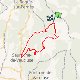
Randonnée Marche de 13,4 km à découvrir à Provence-Alpes-Côte d'Azur, Vaucluse, Le Beaucet. Cette randonnée est proposée par kephas.
Description
Nous atteindrons Saumane par les Trois-Luisants, le Mourre Pelé, Valescure et son Aven, puis nous rentrerons par Bourguigne et la fontaine miraculeuse.
Localisation
Pays :
France
Région :
Provence-Alpes-Côte d'Azur
Département/Province :
Vaucluse
Commune :
Le Beaucet
Localité :
Unknown
Départ:(Dec)
Départ:(UTM)
671817 ; 4870115 (31T) N.
Commentaires
Randonnées à proximité
![Randonnée Marche Fontaine-de-Vaucluse - Fontaine de Vaucluse par l'aven de Valescure, les crêtes et le chateau - Photo](https://media.geolcdn.com/t/375/260/151070e1-18c8-4062-b1e4-7770840cd66e.jpg&format=jpg&maxdim=2)
![Marche Marche](https://static1.geolcdn.com/sitytour/trail-icons/101.png)
Fontaine de Vaucluse par l'aven de Valescure, les crêtes et le chateau
Marche
Difficile
(1)
Fontaine-de-Vaucluse,
Provence-Alpes-Côte d'Azur,
Vaucluse,
France
![](/images/other/stat-length.png)
15,1 km | 25 km-effort
6h 23min
![](https://static1.geolcdn.com/siteimages/upload/files/16400158638029165_repeat_loop_refresh_sync_direction_icon.png)
Oui
![Randonnée Moteur La Roque-sur-Pernes - le beaucet - Photo](https://media.geolcdn.com/t/375/260/ext.jpg?maxdim=2&url=https%3A%2F%2Fservices.sitytrail.com%2FGeolivesWS%2FDownloadMedia.ashx%3FTrailID%3D386013%26Media%3D20150213102403.jpg)
![Moteur Moteur](https://static1.geolcdn.com/sitytour/trail-icons/400.png)
le beaucet
Moteur
Facile
(1)
La Roque-sur-Pernes,
Provence-Alpes-Côte d'Azur,
Vaucluse,
France
![](/images/other/stat-length.png)
8,1 km | 10,8 km-effort
2h 52min
![](https://static1.geolcdn.com/siteimages/upload/files/16400158638029165_repeat_loop_refresh_sync_direction_icon.png)
Oui
![Randonnée Marche Saumane-de-Vaucluse - Saumane-de-Vaucluse très belle ballade - Photo](https://media.geolcdn.com/t/375/260/f13a2583-4146-473c-8c72-3b4870c42b13.jpg&format=jpg&maxdim=2)
![Marche Marche](https://static1.geolcdn.com/sitytour/trail-icons/101.png)
Saumane-de-Vaucluse très belle ballade
Marche
Moyen
(1)
Saumane-de-Vaucluse,
Provence-Alpes-Côte d'Azur,
Vaucluse,
France
![](/images/other/stat-length.png)
8,5 km | 13 km-effort
2h 28min
![](https://static1.geolcdn.com/siteimages/upload/files/16400158638029165_repeat_loop_refresh_sync_direction_icon.png)
Oui
![Randonnée Marche Venasque - Venasque - Photo](https://media.geolcdn.com/t/375/260/ext.jpg?maxdim=2&url=https%3A%2F%2Fservices.sitytrail.com%2FGeolivesWS%2FDownloadMedia.ashx%3FTrailID%3D170316%26Media%3D20130116102457.jpeg)
![Marche Marche](https://static1.geolcdn.com/sitytour/trail-icons/101.png)
Venasque
Marche
Facile
(3)
Venasque,
Provence-Alpes-Côte d'Azur,
Vaucluse,
France
![](/images/other/stat-length.png)
13,1 km | 19,3 km-effort
4h 10min
![](https://static1.geolcdn.com/siteimages/upload/files/16400158638029165_repeat_loop_refresh_sync_direction_icon.png)
Oui
![Randonnée Marche Saumane-de-Vaucluse - Saumane de Vaucluse / St Gens - Photo](https://media.geolcdn.com/t/375/260/ad5fcb13-12d4-40a2-8637-46a71dbe09db.jpg&format=jpg&maxdim=2)
![Marche Marche](https://static1.geolcdn.com/sitytour/trail-icons/101.png)
Saumane de Vaucluse / St Gens
Marche
Difficile
Saumane-de-Vaucluse,
Provence-Alpes-Côte d'Azur,
Vaucluse,
France
![](/images/other/stat-length.png)
20 km | 32 km-effort
6h 1min
![](https://static1.geolcdn.com/siteimages/upload/files/16400158638029165_repeat_loop_refresh_sync_direction_icon.png)
Oui
![V.T.T. V.T.T.](https://static1.geolcdn.com/sitytour/trail-icons/202.png)
VTT de Gordes à Fontaine-de-Vaucluse
V.T.T.
Très difficile
Gordes,
Provence-Alpes-Côte d'Azur,
Vaucluse,
France
![](/images/other/stat-length.png)
35 km | 49 km-effort
3h 22min
![](https://static1.geolcdn.com/siteimages/upload/files/16400158638029165_repeat_loop_refresh_sync_direction_icon.png)
Oui
![Randonnée Marche Saumane-de-Vaucluse - Saumane de Vaucluse / St Gens - Photo](https://media.geolcdn.com/t/375/260/0c9ad01a-5b0c-44c1-939a-8e6252f252a0.jpg&format=jpg&maxdim=2)
![Marche Marche](https://static1.geolcdn.com/sitytour/trail-icons/101.png)
Saumane de Vaucluse / St Gens
Marche
Moyen
Saumane-de-Vaucluse,
Provence-Alpes-Côte d'Azur,
Vaucluse,
France
![](/images/other/stat-length.png)
13,1 km | 21 km-effort
4h 25min
![](https://static1.geolcdn.com/siteimages/upload/files/16400158638029165_repeat_loop_refresh_sync_direction_icon.png)
Non
![V.T.T. V.T.T.](https://static1.geolcdn.com/sitytour/trail-icons/202.png)
VTT autour de Gordes.
V.T.T.
Très facile
Gordes,
Provence-Alpes-Côte d'Azur,
Vaucluse,
France
![](/images/other/stat-length.png)
20 km | 27 km-effort
Inconnu
![](https://static1.geolcdn.com/siteimages/upload/files/16400158638029165_repeat_loop_refresh_sync_direction_icon.png)
Oui
![A pied A pied](https://static1.geolcdn.com/sitytour/trail-icons/100.png)
Gordes 10 km
A pied
Difficile
Gordes,
Provence-Alpes-Côte d'Azur,
Vaucluse,
France
![](/images/other/stat-length.png)
9,2 km | 13 km-effort
Inconnu
![](https://static1.geolcdn.com/siteimages/upload/files/16400158638029165_repeat_loop_refresh_sync_direction_icon.png)
Non