![](/images/other/stat-length.png)
![Randonnée Marche Bunyola - Orient - Alfabia - Photo](https://media.geolcdn.com/t/1900/400/ext.pjpeg?maxdim=2&url=https%3A%2F%2Fstatic1.geolcdn.com%2Fsiteimages%2Fupload%2Ffiles%2F1553511878bg_sport_marche.png)
Orient - Alfabia
michelek
Utilisateur
![Longueur](/images/other/stat-length.png)
Longueur
13,2 km
![Altitude max](https://static1.geolcdn.com/siteimages/upload/files/1508320355ic_sort_altitude_max_24dp.png)
Altitude max
1054 m
![Dénivelé positif](https://static1.geolcdn.com/siteimages/upload/files/1508320355ic_sort_den_pos_24dp.png)
Dénivelé positif
716 m
![Km-Effort](/images/other/stat-length.png)
Km-Effort
23 km
![Altitude min](https://static1.geolcdn.com/siteimages/upload/files/1508320355ic_sort_altitude_min_24dp.png)
Altitude min
426 m
![Dénivelé négatif](https://static1.geolcdn.com/siteimages/upload/files/1508320355ic_sort_den_neg_24dp.png)
Dénivelé négatif
717 m
![Boucle](https://static1.geolcdn.com/siteimages/upload/files/16400158638029165_repeat_loop_refresh_sync_direction_icon.png)
Boucle
Oui
Date de création :
2018-11-10 10:10:22.423
Dernière modification :
2018-11-10 10:10:22.695
![Marche](https://static1.geolcdn.com/sitytour/trail-icons/101.png)
4h40
Difficulté : Moyen
![Scannez ce code QR pour ouvrir la randonnée dans l'application SityTrail](https://capi.geolives.com/qq0zvz2zws4bq2lad0pu/sitytour/trails/161102/qr.png?size=200)
Application GPS de randonnée GRATUITE
À propos
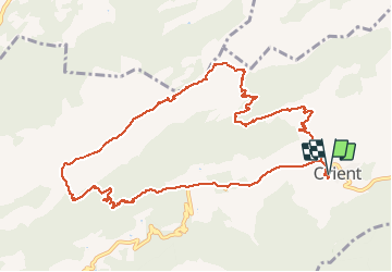
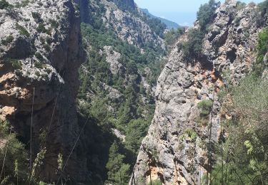
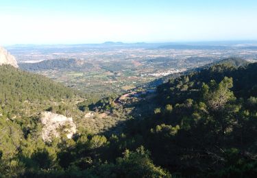
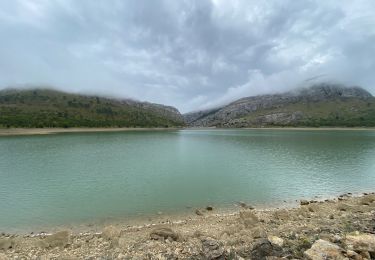
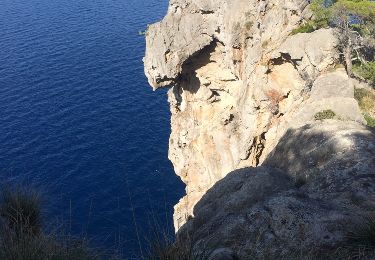
Randonnée Marche de 13,2 km à découvrir à Îles Baléares, Inconnu, Bunyola. Cette randonnée est proposée par michelek.
Description
Randonnée sportive au départ d'Orient.
La navigation est assez évidente jusqu'au sommet de la Serra. Ensuite, plus de sentier, bien suivre les quelques cairns. Le GPS vous aidera.
Localisation
Pays :
Espagne
Région :
Îles Baléares
Département/Province :
Inconnu
Commune :
Bunyola
Localité :
Unknown
Départ:(Dec)
Départ:(UTM)
479300 ; 4398294 (31S) N.
Commentaires
Randonnées à proximité
![Randonnée Marche Sóller - MAJORQUE - Gorges de Biniaraix (SOLLER) - Photo](https://media.geolcdn.com/t/375/260/51733406-bf06-4275-a18a-d423756de85c.jpg&format=jpg&maxdim=2)
![Marche Marche](https://static1.geolcdn.com/sitytour/trail-icons/101.png)
MAJORQUE - Gorges de Biniaraix (SOLLER)
Marche
Difficile
Sóller,
Îles Baléares,
Inconnu,
Espagne
![](/images/other/stat-length.png)
9,1 km | 19,1 km-effort
2h 49min
![](https://static1.geolcdn.com/siteimages/upload/files/16400158638029165_repeat_loop_refresh_sync_direction_icon.png)
Oui
![Randonnée A pied Alaró - ES-14 AC - Photo](https://media.geolcdn.com/t/375/260/b00e83eb-40d8-43b9-a0ec-9b667b6177cb.jpeg&format=jpg&maxdim=2)
![A pied A pied](https://static1.geolcdn.com/sitytour/trail-icons/100.png)
![Randonnée Marche Sóller - GR221 # Soller - Pas Llis - Refuge Tossals Verds - Photo](https://media.geolcdn.com/t/375/260/e8d28a15-8241-4fba-8d38-462bd75ed5d3.jpeg&format=jpg&maxdim=2)
![Marche Marche](https://static1.geolcdn.com/sitytour/trail-icons/101.png)
GR221 # Soller - Pas Llis - Refuge Tossals Verds
Marche
Difficile
(1)
Sóller,
Îles Baléares,
Inconnu,
Espagne
![](/images/other/stat-length.png)
17,6 km | 31 km-effort
5h 39min
![](https://static1.geolcdn.com/siteimages/upload/files/16400158638029165_repeat_loop_refresh_sync_direction_icon.png)
Non
![Randonnée Marche Bunyola - Mallorca-Bunyola 17-10-2017 - Photo](https://media.geolcdn.com/t/375/260/ext.jpg?maxdim=2&url=https%3A%2F%2Fstatic1.geolcdn.com%2Fsiteimages%2Fupload%2Ffiles%2F1553511878bg_sport_marche.png)
![Marche Marche](https://static1.geolcdn.com/sitytour/trail-icons/101.png)
Mallorca-Bunyola 17-10-2017
Marche
Facile
Bunyola,
Îles Baléares,
Inconnu,
Espagne
![](/images/other/stat-length.png)
12,7 km | 21 km-effort
3h 39min
![](https://static1.geolcdn.com/siteimages/upload/files/16400158638029165_repeat_loop_refresh_sync_direction_icon.png)
Oui
![Randonnée Marche Sóller - soller-capella de castello-bens d avall-punta de soller-cap gros-port de soller - Photo](https://media.geolcdn.com/t/375/260/ext.jpg?maxdim=2&url=https%3A%2F%2Fservices.sitytrail.com%2FGeolivesWS%2FDownloadMedia.ashx%3FTrailID%3D356795%26Media%3D20141021151209.jpg)
![Marche Marche](https://static1.geolcdn.com/sitytour/trail-icons/101.png)
soller-capella de castello-bens d avall-punta de soller-cap gros-port de soller
Marche
Facile
Sóller,
Îles Baléares,
Inconnu,
Espagne
![](/images/other/stat-length.png)
18,5 km | 26 km-effort
5h 45min
![](https://static1.geolcdn.com/siteimages/upload/files/16400158638029165_repeat_loop_refresh_sync_direction_icon.png)
Non
![Randonnée Marche Fornalutx - Soller Mallorca - Photo](https://media.geolcdn.com/t/375/260/ext.jpg?maxdim=2&url=https%3A%2F%2Fservices.sitytrail.com%2FGeolivesWS%2FDownloadMedia.ashx%3FTrailID%3D229655%26Media%3Dfix__20131025153557.jpg)
![Marche Marche](https://static1.geolcdn.com/sitytour/trail-icons/101.png)
Soller Mallorca
Marche
Moyen
Fornalutx,
Îles Baléares,
Inconnu,
Espagne
![](/images/other/stat-length.png)
10,4 km | 20 km-effort
4h 1min
![](https://static1.geolcdn.com/siteimages/upload/files/16400158638029165_repeat_loop_refresh_sync_direction_icon.png)
Oui
![Randonnée Marche Fornalutx - Soller Mallorca - Photo](https://media.geolcdn.com/t/375/260/ext.jpg?maxdim=2&url=https%3A%2F%2Fservices.sitytrail.com%2FGeolivesWS%2FDownloadMedia.ashx%3FTrailID%3D229654%26Media%3Dfix__20131025153557.jpg)
![Marche Marche](https://static1.geolcdn.com/sitytour/trail-icons/101.png)
Soller Mallorca
Marche
Moyen
Fornalutx,
Îles Baléares,
Inconnu,
Espagne
![](/images/other/stat-length.png)
10,4 km | 20 km-effort
4h 1min
![](https://static1.geolcdn.com/siteimages/upload/files/16400158638029165_repeat_loop_refresh_sync_direction_icon.png)
Oui
![Randonnée Marche Sóller - boucle villages binibassi fornalutx et biniaraix - Photo](https://media.geolcdn.com/t/375/260/ext.jpg?maxdim=2&url=https%3A%2F%2Fstatic1.geolcdn.com%2Fsiteimages%2Fupload%2Ffiles%2F1553511878bg_sport_marche.png)
![Marche Marche](https://static1.geolcdn.com/sitytour/trail-icons/101.png)
boucle villages binibassi fornalutx et biniaraix
Marche
Facile
(1)
Sóller,
Îles Baléares,
Inconnu,
Espagne
![](/images/other/stat-length.png)
10,1 km | 14,8 km-effort
2h 47min
![](https://static1.geolcdn.com/siteimages/upload/files/16400158638029165_repeat_loop_refresh_sync_direction_icon.png)
Non
![Randonnée Vélo de route Sóller - Soller -st luc - Photo](https://media.geolcdn.com/t/375/260/ext.jpg?maxdim=2&url=https%3A%2F%2Fstatic1.geolcdn.com%2Fsiteimages%2Fupload%2Ffiles%2F1524743154velo.jpg)
![Vélo de route Vélo de route](https://static1.geolcdn.com/sitytour/trail-icons/201.png)
Soller -st luc
Vélo de route
Moyen
Sóller,
Îles Baléares,
Inconnu,
Espagne
![](/images/other/stat-length.png)
36 km | 53 km-effort
4h 37min
![](https://static1.geolcdn.com/siteimages/upload/files/16400158638029165_repeat_loop_refresh_sync_direction_icon.png)
Non