


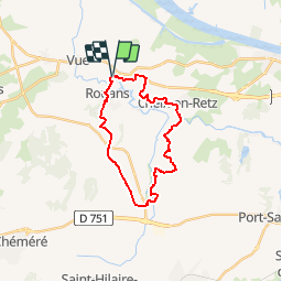


21 km | 23 km-effort


Utilisateur


Application GPS de randonnée GRATUITE
 SityTrail
IGN / Instituts géographiques
SityTrail World
Le monde est à vous
Randonnée Marche de 21 km à découvrir à Pays de la Loire, Loire-Atlantique, Rouans. Cette randonnée est proposée par Mitche44.
Le village du Grand Chemin servit de cadre au tournage du film Le Grand Chemin de Jean-Loup Hubert en 1987. Découvrez les coteaux de Rouans, les marais, le village pittoresque de Buzon (ancien port).

Marche
A pied
Marche
Marche
Marche
Marche

V.T.T.
Marche
V.T.T.
chezine