![](/images/other/stat-length.png)
![Randonnée Marche Vaufrey - Bords du Doubs entre Vaufrey et Premoncourt - Photo](https://media.geolcdn.com/t/1900/400/ext.pjpeg?maxdim=2&url=https%3A%2F%2Fstatic1.geolcdn.com%2Fsiteimages%2Fupload%2Ffiles%2F1553511878bg_sport_marche.png)
Bords du Doubs entre Vaufrey et Premoncourt
ballet
Utilisateur
![Longueur](/images/other/stat-length.png)
Longueur
24 km
![Altitude max](https://static1.geolcdn.com/siteimages/upload/files/1508320355ic_sort_altitude_max_24dp.png)
Altitude max
491 m
![Dénivelé positif](https://static1.geolcdn.com/siteimages/upload/files/1508320355ic_sort_den_pos_24dp.png)
Dénivelé positif
509 m
![Km-Effort](/images/other/stat-length.png)
Km-Effort
31 km
![Altitude min](https://static1.geolcdn.com/siteimages/upload/files/1508320355ic_sort_altitude_min_24dp.png)
Altitude min
397 m
![Dénivelé négatif](https://static1.geolcdn.com/siteimages/upload/files/1508320355ic_sort_den_neg_24dp.png)
Dénivelé négatif
506 m
![Boucle](https://static1.geolcdn.com/siteimages/upload/files/16400158638029165_repeat_loop_refresh_sync_direction_icon.png)
Boucle
Oui
Date de création :
2014-12-10 00:00:00.0
Dernière modification :
2014-12-10 00:00:00.0
![Marche](https://static1.geolcdn.com/sitytour/trail-icons/101.png)
5h00
Difficulté : Moyen
![Scannez ce code QR pour ouvrir la randonnée dans l'application SityTrail](https://capi.geolives.com/qq0zvz2zws4bq2lad0pu/sitytour/trails/158898/qr.png?size=200)
Application GPS de randonnée GRATUITE
À propos
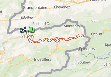
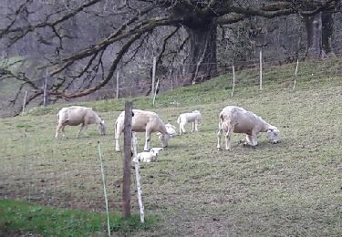
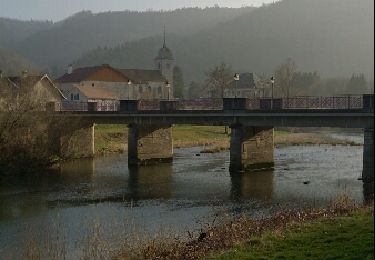
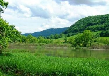
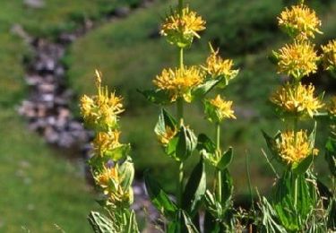
Randonnée Marche de 24 km à découvrir à Bourgogne-Franche-Comté, Doubs, Vaufrey. Cette randonnée est proposée par ballet.
Description
Pour les amoureux du Doubs
Balade d'une bonne longueur avec une succession de montées et descentes au fil des contours du Doubs pour un dénivelé cumulé de 500m
Localisation
Pays :
France
Région :
Bourgogne-Franche-Comté
Département/Province :
Doubs
Commune :
Vaufrey
Localité :
Unknown
Départ:(Dec)
Départ:(UTM)
343118 ; 5245808 (32T) N.
Commentaires
Randonnées à proximité
![Randonnée A pied Haute-Ajoie - Tour de Faux d'Enson - fixme - Photo](https://media.geolcdn.com/t/375/260/3d6245ea-05b2-40cb-a2e7-b86694bd3412.jpeg&format=jpg&maxdim=2)
![A pied A pied](https://static1.geolcdn.com/sitytour/trail-icons/100.png)
Tour de Faux d'Enson - fixme
A pied
Facile
Haute-Ajoie,
Jura,
District de Porrentruy,
Suisse
![](/images/other/stat-length.png)
4,5 km | 6,1 km-effort
1h 22min
![](https://static1.geolcdn.com/siteimages/upload/files/16400158638029165_repeat_loop_refresh_sync_direction_icon.png)
Non
![Randonnée A pied Haute-Ajoie - Tour de Faux d'Enson - Rocourt - Photo](https://media.geolcdn.com/t/375/260/3d6245ea-05b2-40cb-a2e7-b86694bd3412.jpeg&format=jpg&maxdim=2)
![A pied A pied](https://static1.geolcdn.com/sitytour/trail-icons/100.png)
Tour de Faux d'Enson - Rocourt
A pied
Facile
Haute-Ajoie,
Jura,
District de Porrentruy,
Suisse
![](/images/other/stat-length.png)
5,3 km | 7 km-effort
1h 36min
![](https://static1.geolcdn.com/siteimages/upload/files/16400158638029165_repeat_loop_refresh_sync_direction_icon.png)
Non
![Randonnée Marche Montjoie-le-Château - montjoie le château - Photo](https://media.geolcdn.com/t/375/260/1275a0bb-1a3e-4c4f-aef4-068bfe7ae2bf.jpg&format=jpg&maxdim=2)
![Marche Marche](https://static1.geolcdn.com/sitytour/trail-icons/101.png)
montjoie le château
Marche
Moyen
Montjoie-le-Château,
Bourgogne-Franche-Comté,
Doubs,
France
![](/images/other/stat-length.png)
13 km | 20 km-effort
3h 45min
![](https://static1.geolcdn.com/siteimages/upload/files/16400158638029165_repeat_loop_refresh_sync_direction_icon.png)
Oui
![Randonnée sport Courtefontaine - Courtefontaine - Photo](https://media.geolcdn.com/t/375/260/dd8684d9-af73-4260-bc46-e9b6e4962686.jpg&format=jpg&maxdim=2)
Courtefontaine
sport
Très facile
Courtefontaine,
Bourgogne-Franche-Comté,
Doubs,
France
![](/images/other/stat-length.png)
12,8 km | 17,7 km-effort
Inconnu
![](https://static1.geolcdn.com/siteimages/upload/files/16400158638029165_repeat_loop_refresh_sync_direction_icon.png)
Oui
![Randonnée Marche Haute-Ajoie - Circuit des fermes 26-03-17 - Photo](https://media.geolcdn.com/t/375/260/ext.jpg?maxdim=2&url=https%3A%2F%2Fservices.sitytrail.com%2FGeolivesWS%2FDownloadMedia.ashx%3FTrailID%3D720935%26Media%3Dfix__20170326153126.jpg)
![Marche Marche](https://static1.geolcdn.com/sitytour/trail-icons/101.png)
Circuit des fermes 26-03-17
Marche
Facile
Haute-Ajoie,
Jura,
District de Porrentruy,
Suisse
![](/images/other/stat-length.png)
11,6 km | 18,3 km-effort
4h 7min
![](https://static1.geolcdn.com/siteimages/upload/files/16400158638029165_repeat_loop_refresh_sync_direction_icon.png)
Oui
![Randonnée Marche Villars-lès-Blamont - Sappois - Photo](https://media.geolcdn.com/t/375/260/ext.jpg?maxdim=2&url=https%3A%2F%2Fservices.sitytrail.com%2FGeolivesWS%2FDownloadMedia.ashx%3FTrailID%3D705523%26Media%3Dfix__20170226134415.jpg)
![Marche Marche](https://static1.geolcdn.com/sitytour/trail-icons/101.png)
Sappois
Marche
Moyen
Villars-lès-Blamont,
Bourgogne-Franche-Comté,
Doubs,
France
![](/images/other/stat-length.png)
15,7 km | 23 km-effort
5h 15min
![](https://static1.geolcdn.com/siteimages/upload/files/16400158638029165_repeat_loop_refresh_sync_direction_icon.png)
Oui
![Randonnée Marche Soulce-Cernay - la grotte - Photo](https://media.geolcdn.com/t/375/260/ext.jpg?maxdim=2&url=https%3A%2F%2Fservices.sitytrail.com%2FGeolivesWS%2FDownloadMedia.ashx%3FTrailID%3D255992%26Media%3Dfix__20140310164415.jpg)
![Marche Marche](https://static1.geolcdn.com/sitytour/trail-icons/101.png)
la grotte
Marche
Moyen
Soulce-Cernay,
Bourgogne-Franche-Comté,
Doubs,
France
![](/images/other/stat-length.png)
6,6 km | 11,1 km-effort
2h 24min
![](https://static1.geolcdn.com/siteimages/upload/files/16400158638029165_repeat_loop_refresh_sync_direction_icon.png)
Oui
![Randonnée Marche Haute-Ajoie - Sur les Monts du Lomont 2/2 - De Montavon à Montécheroux, par Vaufrey et la Borne 452 - Photo](https://media.geolcdn.com/t/375/260/ext.jpg?maxdim=2&url=https%3A%2F%2Fservices.sitytrail.com%2FGeolivesWS%2FDownloadMedia.ashx%3FTrailID%3D109673%26Media%3D4321_1.jpg)
![Marche Marche](https://static1.geolcdn.com/sitytour/trail-icons/101.png)
Sur les Monts du Lomont 2/2 - De Montavon à Montécheroux, par Vaufrey et la B...
Marche
Difficile
Haute-Ajoie,
Jura,
District de Porrentruy,
Suisse
![](/images/other/stat-length.png)
21 km | 32 km-effort
6h 0min
![](https://static1.geolcdn.com/siteimages/upload/files/16400158638029165_repeat_loop_refresh_sync_direction_icon.png)
Non
![Randonnée Marche Vaufrey - Le Circuit des Fermes - Doubs - Photo](https://media.geolcdn.com/t/375/260/ext.jpg?maxdim=2&url=https%3A%2F%2Fservices.sitytrail.com%2FGeolivesWS%2FDownloadMedia.ashx%3FTrailID%3D108928%26Media%3D2619_1.jpg)
![Marche Marche](https://static1.geolcdn.com/sitytour/trail-icons/101.png)
Le Circuit des Fermes - Doubs
Marche
Difficile
Vaufrey,
Bourgogne-Franche-Comté,
Doubs,
France
![](/images/other/stat-length.png)
11,2 km | 17,6 km-effort
4h 0min
![](https://static1.geolcdn.com/siteimages/upload/files/16400158638029165_repeat_loop_refresh_sync_direction_icon.png)
Oui