![](/images/other/stat-length.png)
![Randonnée Marche Saint-Germain-Laval - St Germain Laval Verrières - Photo](https://media.geolcdn.com/t/1900/400/ext.pjpeg?maxdim=2&url=https%3A%2F%2Fservices.sitytrail.com%2FGeolivesWS%2FDownloadMedia.ashx%3FTrailID%3D156439%26Media%3D20121002165602.jpg)
St Germain Laval Verrières
gannet1
Utilisateur
![Longueur](/images/other/stat-length.png)
Longueur
10,1 km
![Altitude max](https://static1.geolcdn.com/siteimages/upload/files/1508320355ic_sort_altitude_max_24dp.png)
Altitude max
581 m
![Dénivelé positif](https://static1.geolcdn.com/siteimages/upload/files/1508320355ic_sort_den_pos_24dp.png)
Dénivelé positif
287 m
![Km-Effort](/images/other/stat-length.png)
Km-Effort
13,9 km
![Altitude min](https://static1.geolcdn.com/siteimages/upload/files/1508320355ic_sort_altitude_min_24dp.png)
Altitude min
359 m
![Dénivelé négatif](https://static1.geolcdn.com/siteimages/upload/files/1508320355ic_sort_den_neg_24dp.png)
Dénivelé négatif
298 m
![Boucle](https://static1.geolcdn.com/siteimages/upload/files/16400158638029165_repeat_loop_refresh_sync_direction_icon.png)
Boucle
Oui
Date de création :
2014-12-10 00:00:00.0
Dernière modification :
2014-12-10 00:00:00.0
![Marche](https://static1.geolcdn.com/sitytour/trail-icons/101.png)
2h30
Difficulté : Moyen
![Scannez ce code QR pour ouvrir la randonnée dans l'application SityTrail](https://capi.geolives.com/qq0zvz2zws4bq2lad0pu/sitytour/trails/156439/qr.png?size=200)
Application GPS de randonnée GRATUITE
À propos
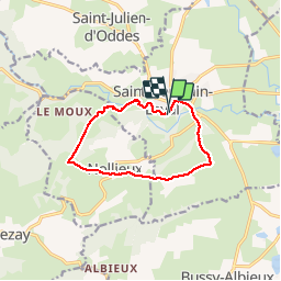
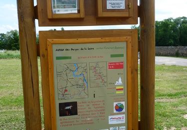
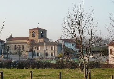
Randonnée Marche de 10,1 km à découvrir à Auvergne-Rhône-Alpes, Loire, Saint-Germain-Laval. Cette randonnée est proposée par gannet1.
Description
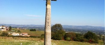
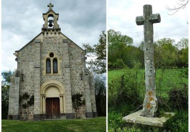
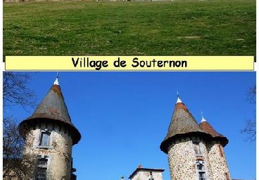
Baffy : chapelle avec une vierge noire
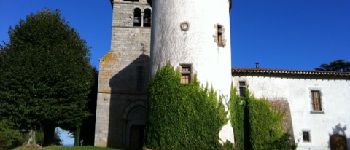
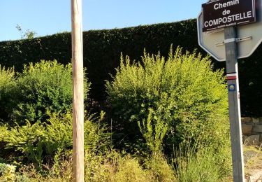
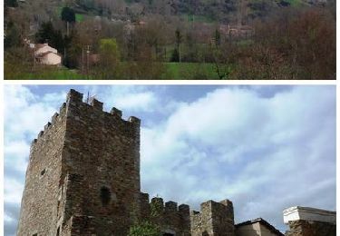
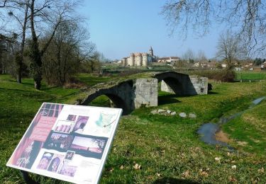
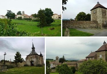
Verrières : ancienne commanderie des templiers située sur le chemin de Compostelle en provenance de Cluny.
900m de dénivelé cumulé en montée
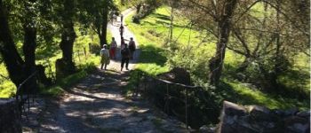
Localisation
Pays :
France
Région :
Auvergne-Rhône-Alpes
Département/Province :
Loire
Commune :
Saint-Germain-Laval
Localité :
Unknown
Départ:(Dec)
Départ:(UTM)
578728 ; 5075446 (31T) N.
Commentaires
Randonnées à proximité
![Randonnée Marche Pommiers-en-Forez - Autour des Gorges de la Loire - GR de Pays N° 3 : le prieuré et la forêt de Bas - Pommiers - Photo](https://media.geolcdn.com/t/375/260/ext.jpg?maxdim=2&url=https%3A%2F%2Fservices.sitytrail.com%2FGeolivesWS%2FDownloadMedia.ashx%3FTrailID%3D215008%26Media%3D15576_6.jpg)
![Marche Marche](https://static1.geolcdn.com/sitytour/trail-icons/101.png)
Autour des Gorges de la Loire - GR de Pays N° 3 : le prieuré et la forêt de B...
Marche
Moyen
(1)
Pommiers-en-Forez,
Auvergne-Rhône-Alpes,
Loire,
France
![](/images/other/stat-length.png)
22 km | 26 km-effort
5h 0min
![](https://static1.geolcdn.com/siteimages/upload/files/16400158638029165_repeat_loop_refresh_sync_direction_icon.png)
Oui
![Randonnée Marche Bussy-Albieux - rando au départ de Bussy Albieux - Photo](https://media.geolcdn.com/t/375/260/1eea7c6f-50ba-409b-b185-5ebc59a50053.jpg&format=jpg&maxdim=2)
![Marche Marche](https://static1.geolcdn.com/sitytour/trail-icons/101.png)
rando au départ de Bussy Albieux
Marche
Facile
Bussy-Albieux,
Auvergne-Rhône-Alpes,
Loire,
France
![](/images/other/stat-length.png)
9,7 km | 12 km-effort
2h 31min
![](https://static1.geolcdn.com/siteimages/upload/files/16400158638029165_repeat_loop_refresh_sync_direction_icon.png)
Oui
![Randonnée V.T.T. Pommiers-en-Forez - Boucle de l'eau plate - Pommiers en Forez - Photo](https://media.geolcdn.com/t/375/260/ext.jpg?maxdim=2&url=https%3A%2F%2Fservices.sitytrail.com%2FGeolivesWS%2FDownloadMedia.ashx%3FTrailID%3D317824%26Media%3D17173_4.jpg)
![V.T.T. V.T.T.](https://static1.geolcdn.com/sitytour/trail-icons/202.png)
Boucle de l'eau plate - Pommiers en Forez
V.T.T.
Facile
(1)
Pommiers-en-Forez,
Auvergne-Rhône-Alpes,
Loire,
France
![](/images/other/stat-length.png)
29 km | 32 km-effort
2h 30min
![](https://static1.geolcdn.com/siteimages/upload/files/16400158638029165_repeat_loop_refresh_sync_direction_icon.png)
Oui
![Randonnée V.T.T. Saint-Germain-Laval - Val d'Aix et Mines de Corent - Saint Germain Laval - Photo](https://media.geolcdn.com/t/375/260/ext.jpg?maxdim=2&url=https%3A%2F%2Fservices.sitytrail.com%2FGeolivesWS%2FDownloadMedia.ashx%3FTrailID%3D317783%26Media%3D17098_6.jpg)
![V.T.T. V.T.T.](https://static1.geolcdn.com/sitytour/trail-icons/202.png)
Val d'Aix et Mines de Corent - Saint Germain Laval
V.T.T.
Difficile
Saint-Germain-Laval,
Auvergne-Rhône-Alpes,
Loire,
France
![](/images/other/stat-length.png)
33 km | 45 km-effort
3h 30min
![](https://static1.geolcdn.com/siteimages/upload/files/16400158638029165_repeat_loop_refresh_sync_direction_icon.png)
Oui
![Randonnée V.T.T. Pommiers-en-Forez - Pommiers et Le Poirier - Pommiers en Forez - Photo](https://media.geolcdn.com/t/375/260/ext.jpg?maxdim=2&url=https%3A%2F%2Fservices.sitytrail.com%2FGeolivesWS%2FDownloadMedia.ashx%3FTrailID%3D317782%26Media%3D17097_6.jpg)
![V.T.T. V.T.T.](https://static1.geolcdn.com/sitytour/trail-icons/202.png)
Pommiers et Le Poirier - Pommiers en Forez
V.T.T.
Difficile
Pommiers-en-Forez,
Auvergne-Rhône-Alpes,
Loire,
France
![](/images/other/stat-length.png)
43 km | 50 km-effort
3h 0min
![](https://static1.geolcdn.com/siteimages/upload/files/16400158638029165_repeat_loop_refresh_sync_direction_icon.png)
Oui
![Randonnée V.T.T. Saint-Julien-d'Oddes - Le Val d'Aix sauvage - Saint Julien d'Oddes - Photo](https://media.geolcdn.com/t/375/260/ext.jpg?maxdim=2&url=https%3A%2F%2Fservices.sitytrail.com%2FGeolivesWS%2FDownloadMedia.ashx%3FTrailID%3D317781%26Media%3D17096_6.jpg)
![V.T.T. V.T.T.](https://static1.geolcdn.com/sitytour/trail-icons/202.png)
Le Val d'Aix sauvage - Saint Julien d'Oddes
V.T.T.
Difficile
Saint-Julien-d'Oddes,
Auvergne-Rhône-Alpes,
Loire,
France
![](/images/other/stat-length.png)
32 km | 43 km-effort
3h 30min
![](https://static1.geolcdn.com/siteimages/upload/files/16400158638029165_repeat_loop_refresh_sync_direction_icon.png)
Oui
![Randonnée V.T.T. Grézolles - La vallée de l'Aix sauvage - Grézolles - Photo](https://media.geolcdn.com/t/375/260/ext.jpg?maxdim=2&url=https%3A%2F%2Fservices.sitytrail.com%2FGeolivesWS%2FDownloadMedia.ashx%3FTrailID%3D317779%26Media%3D17094_5.jpg)
![V.T.T. V.T.T.](https://static1.geolcdn.com/sitytour/trail-icons/202.png)
La vallée de l'Aix sauvage - Grézolles
V.T.T.
Difficile
Grézolles,
Auvergne-Rhône-Alpes,
Loire,
France
![](/images/other/stat-length.png)
33 km | 43 km-effort
3h 0min
![](https://static1.geolcdn.com/siteimages/upload/files/16400158638029165_repeat_loop_refresh_sync_direction_icon.png)
Oui
![Randonnée V.T.T. Souternon - Boucle aux confins du pays d'Urfé et du Val d'Isable - Souternon - Photo](https://media.geolcdn.com/t/375/260/ext.jpg?maxdim=2&url=https%3A%2F%2Fservices.sitytrail.com%2FGeolivesWS%2FDownloadMedia.ashx%3FTrailID%3D317778%26Media%3D17093_6.jpg)
![V.T.T. V.T.T.](https://static1.geolcdn.com/sitytour/trail-icons/202.png)
Boucle aux confins du pays d'Urfé et du Val d'Isable - Souternon
V.T.T.
Difficile
Souternon,
Auvergne-Rhône-Alpes,
Loire,
France
![](/images/other/stat-length.png)
34 km | 44 km-effort
3h 0min
![](https://static1.geolcdn.com/siteimages/upload/files/16400158638029165_repeat_loop_refresh_sync_direction_icon.png)
Oui
![Randonnée V.T.T. Grézolles - VTT au fil de l'Aix - Grézolles - Photo](https://media.geolcdn.com/t/375/260/ext.jpg?maxdim=2&url=https%3A%2F%2Fservices.sitytrail.com%2FGeolivesWS%2FDownloadMedia.ashx%3FTrailID%3D316950%26Media%3D16063_6.jpg)
![V.T.T. V.T.T.](https://static1.geolcdn.com/sitytour/trail-icons/202.png)
VTT au fil de l'Aix - Grézolles
V.T.T.
Difficile
Grézolles,
Auvergne-Rhône-Alpes,
Loire,
France
![](/images/other/stat-length.png)
41 km | 54 km-effort
3h 30min
![](https://static1.geolcdn.com/siteimages/upload/files/16400158638029165_repeat_loop_refresh_sync_direction_icon.png)
Oui