![](/images/other/stat-length.png)
![Randonnée Marche Martelange - Foret Anlier 8kms(Ripé Sart) - Photo](https://media.geolcdn.com/t/1900/400/ext.pjpeg?maxdim=2&url=https%3A%2F%2Fstatic1.geolcdn.com%2Fsiteimages%2Fupload%2Ffiles%2F1553511878bg_sport_marche.png)
Foret Anlier 8kms(Ripé Sart)
BenoitV
Utilisateur
![Longueur](/images/other/stat-length.png)
Longueur
7,9 km
![Altitude max](https://static1.geolcdn.com/siteimages/upload/files/1508320355ic_sort_altitude_max_24dp.png)
Altitude max
521 m
![Dénivelé positif](https://static1.geolcdn.com/siteimages/upload/files/1508320355ic_sort_den_pos_24dp.png)
Dénivelé positif
134 m
![Km-Effort](/images/other/stat-length.png)
Km-Effort
9,7 km
![Altitude min](https://static1.geolcdn.com/siteimages/upload/files/1508320355ic_sort_altitude_min_24dp.png)
Altitude min
460 m
![Dénivelé négatif](https://static1.geolcdn.com/siteimages/upload/files/1508320355ic_sort_den_neg_24dp.png)
Dénivelé négatif
131 m
![Boucle](https://static1.geolcdn.com/siteimages/upload/files/16400158638029165_repeat_loop_refresh_sync_direction_icon.png)
Boucle
Oui
Date de création :
2014-12-10 00:00:00.0
Dernière modification :
2014-12-10 00:00:00.0
![Marche](https://static1.geolcdn.com/sitytour/trail-icons/101.png)
--
Difficulté : Moyen
![Scannez ce code QR pour ouvrir la randonnée dans l'application SityTrail](https://capi.geolives.com/qq0zvz2zws4bq2lad0pu/sitytour/trails/156008/qr.png?size=200)
Application GPS de randonnée GRATUITE
À propos
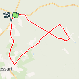
Randonnée Marche de 7,9 km à découvrir à Wallonie, Luxembourg, Martelange. Cette randonnée est proposée par BenoitV.
Description
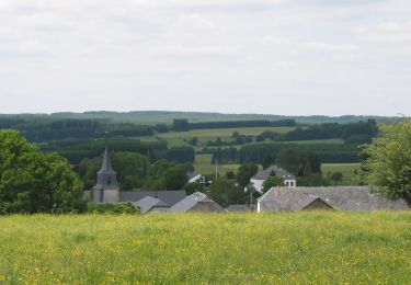
Petite Ballade au coeur de la forêt d'Anlier au lieu dit Ripé Sart. Découverte du village de Vlessart (commune Léglise).
convient pour course à pied et vtt.
Localisation
Pays :
Belgique
Région :
Wallonie
Département/Province :
Luxembourg
Commune :
Martelange
Localité :
Martelange
Départ:(Dec)
Départ:(UTM)
690758 ; 5521026 (31U) N.
Commentaires
Randonnées à proximité
![Randonnée Marche Habay - RB-Lu-11_Anlier - Photo](https://media.geolcdn.com/t/375/260/ext.jpg?maxdim=2&url=https%3A%2F%2Fservices.sitytrail.com%2FGeolivesWS%2FDownloadMedia.ashx%3FTrailID%3D179616%26Media%3D08af71d9-c674-44b1-8950-c42d6cbce43a.jpg)
![Marche Marche](https://static1.geolcdn.com/sitytour/trail-icons/101.png)
RB-Lu-11_Anlier
Marche
Difficile
(8)
Habay,
Wallonie,
Luxembourg,
Belgique
![](/images/other/stat-length.png)
23 km | 29 km-effort
5h 56min
![](https://static1.geolcdn.com/siteimages/upload/files/16400158638029165_repeat_loop_refresh_sync_direction_icon.png)
Oui
![Randonnée Marche Léglise - Traimont Narcimont Variante - Photo](https://media.geolcdn.com/t/375/260/ext.jpg?maxdim=2&url=https%3A%2F%2Fservices.sitytrail.com%2FGeolivesWS%2FDownloadMedia.ashx%3FTrailID%3D1136744%26Media%3D20190419183507.jpg)
![Marche Marche](https://static1.geolcdn.com/sitytour/trail-icons/101.png)
Traimont Narcimont Variante
Marche
Facile
(1)
Léglise,
Wallonie,
Luxembourg,
Belgique
![](/images/other/stat-length.png)
17,9 km | 23 km-effort
3h 5min
![](https://static1.geolcdn.com/siteimages/upload/files/16400158638029165_repeat_loop_refresh_sync_direction_icon.png)
Oui
![Randonnée Marche Martelange - forêt d'Anlier 1 - Photo](https://media.geolcdn.com/t/375/260/ext.jpg?maxdim=2&url=https%3A%2F%2Fservices.sitytrail.com%2FGeolivesWS%2FDownloadMedia.ashx%3FTrailID%3D346727%26Media%3Dfix__20140920101522.jpg)
![Marche Marche](https://static1.geolcdn.com/sitytour/trail-icons/101.png)
forêt d'Anlier 1
Marche
Moyen
(3)
Martelange,
Wallonie,
Luxembourg,
Belgique
![](/images/other/stat-length.png)
10,7 km | 13,1 km-effort
2h 57min
![](https://static1.geolcdn.com/siteimages/upload/files/16400158638029165_repeat_loop_refresh_sync_direction_icon.png)
Oui
![Randonnée Marche Habay - RB-Lu-11_Anlier_via-racc - Photo](https://media.geolcdn.com/t/375/260/ext.jpg?maxdim=2&url=https%3A%2F%2Fservices.sitytrail.com%2FGeolivesWS%2FDownloadMedia.ashx%3FTrailID%3D216796%26Media%3D7c022f6c-85e7-4bd4-8bf7-3a772296d0f7.jpg)
![Marche Marche](https://static1.geolcdn.com/sitytour/trail-icons/101.png)
RB-Lu-11_Anlier_via-racc
Marche
Facile
(1)
Habay,
Wallonie,
Luxembourg,
Belgique
![](/images/other/stat-length.png)
14,5 km | 18,5 km-effort
3h 55min
![](https://static1.geolcdn.com/siteimages/upload/files/16400158638029165_repeat_loop_refresh_sync_direction_icon.png)
Oui
![Randonnée A pied Habay - Sentier de la Cornaille - Photo](https://media.geolcdn.com/t/375/260/4dc1124b-db05-48e7-9b22-5809568cea3b.jpeg&format=jpg&maxdim=2)
![A pied A pied](https://static1.geolcdn.com/sitytour/trail-icons/100.png)
Sentier de la Cornaille
A pied
Moyen
Habay,
Wallonie,
Luxembourg,
Belgique
![](/images/other/stat-length.png)
18,6 km | 23 km-effort
5h 15min
![](https://static1.geolcdn.com/siteimages/upload/files/16400158638029165_repeat_loop_refresh_sync_direction_icon.png)
Oui
![Randonnée A pied Habay - Le Chemin du Harnussiau - Photo](https://media.geolcdn.com/t/375/260/13f640eb-b356-4909-89ab-37ab0047060a.jpeg&format=jpg&maxdim=2)
![A pied A pied](https://static1.geolcdn.com/sitytour/trail-icons/100.png)
Le Chemin du Harnussiau
A pied
Facile
Habay,
Wallonie,
Luxembourg,
Belgique
![](/images/other/stat-length.png)
14,2 km | 17,6 km-effort
3h 59min
![](https://static1.geolcdn.com/siteimages/upload/files/16400158638029165_repeat_loop_refresh_sync_direction_icon.png)
Oui
![Randonnée A pied Fauvillers - Fauvillers Adeps 27-9-2020 de Bernard Gillet... - Photo](https://media.geolcdn.com/t/375/260/ext.jpg?maxdim=2&url=https%3A%2F%2Fstatic1.geolcdn.com%2Fsiteimages%2Fupload%2Ffiles%2F1545311037marcheuse_200dpi.jpg)
![A pied A pied](https://static1.geolcdn.com/sitytour/trail-icons/100.png)
Fauvillers Adeps 27-9-2020 de Bernard Gillet...
A pied
Facile
(1)
Fauvillers,
Wallonie,
Luxembourg,
Belgique
![](/images/other/stat-length.png)
10,5 km | 13,9 km-effort
2h 30min
![](https://static1.geolcdn.com/siteimages/upload/files/16400158638029165_repeat_loop_refresh_sync_direction_icon.png)
Oui
![Randonnée Marche Fauvillers - fauvillers - Photo](https://media.geolcdn.com/t/375/260/ext.jpg?maxdim=2&url=https%3A%2F%2Fstatic1.geolcdn.com%2Fsiteimages%2Fupload%2Ffiles%2F1553511878bg_sport_marche.png)
![Marche Marche](https://static1.geolcdn.com/sitytour/trail-icons/101.png)
fauvillers
Marche
Moyen
(2)
Fauvillers,
Wallonie,
Luxembourg,
Belgique
![](/images/other/stat-length.png)
17,4 km | 22 km-effort
3h 58min
![](https://static1.geolcdn.com/siteimages/upload/files/16400158638029165_repeat_loop_refresh_sync_direction_icon.png)
Oui
![Randonnée Marche Fauvillers - Wikiloc Bodange (PVDB) - Photo](https://media.geolcdn.com/t/375/260/ext.jpg?maxdim=2&url=https%3A%2F%2Fstatic1.geolcdn.com%2Fsiteimages%2Fupload%2Ffiles%2F1553511878bg_sport_marche.png)
![Marche Marche](https://static1.geolcdn.com/sitytour/trail-icons/101.png)
Wikiloc Bodange (PVDB)
Marche
Très facile
(1)
Fauvillers,
Wallonie,
Luxembourg,
Belgique
![](/images/other/stat-length.png)
7,8 km | 10,4 km-effort
Inconnu
![](https://static1.geolcdn.com/siteimages/upload/files/16400158638029165_repeat_loop_refresh_sync_direction_icon.png)
Oui
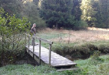
Magnifique chemin forestier dans la forêt d'Anlier !