![](/images/other/stat-length.png)
![Randonnée Marche Villegusien-le-Lac - Heuilley-cotton - Cohons - Longeau - Photo](https://media.geolcdn.com/t/1900/400/ext.pjpeg?maxdim=2&url=https%3A%2F%2Fstatic1.geolcdn.com%2Fsiteimages%2Fupload%2Ffiles%2F1553511878bg_sport_marche.png)
Heuilley-cotton - Cohons - Longeau
indianalou
Utilisateur
![Longueur](/images/other/stat-length.png)
Longueur
17 km
![Altitude max](https://static1.geolcdn.com/siteimages/upload/files/1508320355ic_sort_altitude_max_24dp.png)
Altitude max
457 m
![Dénivelé positif](https://static1.geolcdn.com/siteimages/upload/files/1508320355ic_sort_den_pos_24dp.png)
Dénivelé positif
252 m
![Km-Effort](/images/other/stat-length.png)
Km-Effort
20 km
![Altitude min](https://static1.geolcdn.com/siteimages/upload/files/1508320355ic_sort_altitude_min_24dp.png)
Altitude min
306 m
![Dénivelé négatif](https://static1.geolcdn.com/siteimages/upload/files/1508320355ic_sort_den_neg_24dp.png)
Dénivelé négatif
253 m
![Boucle](https://static1.geolcdn.com/siteimages/upload/files/16400158638029165_repeat_loop_refresh_sync_direction_icon.png)
Boucle
Oui
Date de création :
2014-12-10 00:00:00.0
Dernière modification :
2014-12-10 00:00:00.0
![Marche](https://static1.geolcdn.com/sitytour/trail-icons/101.png)
4h00
Difficulté : Moyen
![Scannez ce code QR pour ouvrir la randonnée dans l'application SityTrail](https://capi.geolives.com/qq0zvz2zws4bq2lad0pu/sitytour/trails/154257/qr.png?size=200)
Application GPS de randonnée GRATUITE
À propos
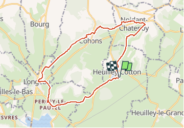
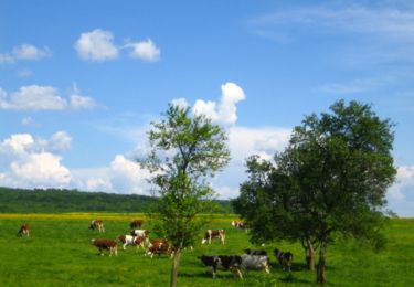
Randonnée Marche de 17 km à découvrir à Grand Est, Haute-Marne, Villegusien-le-Lac. Cette randonnée est proposée par indianalou.
Description
VTT possible
Vous découvrirez:
- une des entrées du tunnel de Balesmes (Canal Marne Saône).
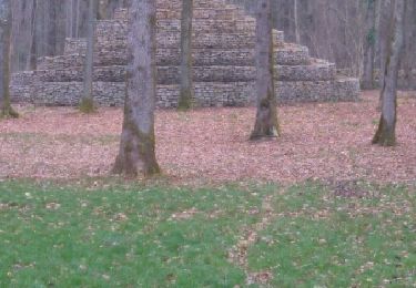
- l'escargot de Cohons
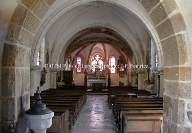
- le Château de Percey-le-Pautel
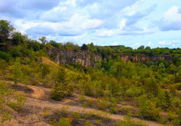
- balade en forêt
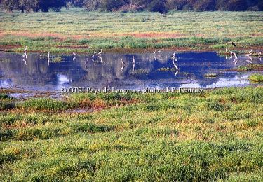
- balade en bord de canal
- ...
- points de vue très sympa !
Localisation
Pays :
France
Région :
Grand Est
Département/Province :
Haute-Marne
Commune :
Villegusien-le-Lac
Localité :
Unknown
Départ:(Dec)
Départ:(UTM)
677246 ; 5293438 (31T) N.
Commentaires
Randonnées à proximité
![Randonnée Marche Longeau-Percey - Tour du Lac de la Vingeanne - Villegusien - Photo](https://media.geolcdn.com/t/375/260/ext.jpg?maxdim=2&url=https%3A%2F%2Fservices.sitytrail.com%2FGeolivesWS%2FDownloadMedia.ashx%3FTrailID%3D108673%26Media%3D1712_2.jpg)
![Marche Marche](https://static1.geolcdn.com/sitytour/trail-icons/101.png)
Tour du Lac de la Vingeanne - Villegusien
Marche
Facile
(2)
Longeau-Percey,
Grand Est,
Haute-Marne,
France
![](/images/other/stat-length.png)
8,6 km | 9,4 km-effort
1h 30min
![](https://static1.geolcdn.com/siteimages/upload/files/16400158638029165_repeat_loop_refresh_sync_direction_icon.png)
Oui
![Randonnée Marche Saints-Geosmes - Boucle 18 km incluant Cohons et la source de la Marne - Photo](https://media.geolcdn.com/t/375/260/3d422adb-0816-44ed-9f3d-740131f7ee60.jpg&format=jpg&maxdim=2)
![Marche Marche](https://static1.geolcdn.com/sitytour/trail-icons/101.png)
Boucle 18 km incluant Cohons et la source de la Marne
Marche
Moyen
Saints-Geosmes,
Grand Est,
Haute-Marne,
France
![](/images/other/stat-length.png)
18,3 km | 22 km-effort
3h 54min
![](https://static1.geolcdn.com/siteimages/upload/files/16400158638029165_repeat_loop_refresh_sync_direction_icon.png)
Oui
![Randonnée Marche Noidant-Chatenoy - source de la marne - Photo](https://media.geolcdn.com/t/375/260/ext.jpg?maxdim=2&url=https%3A%2F%2Fservices.sitytrail.com%2FGeolivesWS%2FDownloadMedia.ashx%3FTrailID%3D555425%26Media%3Dfix__20160315155513.jpg)
![Marche Marche](https://static1.geolcdn.com/sitytour/trail-icons/101.png)
source de la marne
Marche
Moyen
Noidant-Chatenoy,
Grand Est,
Haute-Marne,
France
![](/images/other/stat-length.png)
16 km | 19,8 km-effort
4h 18min
![](https://static1.geolcdn.com/siteimages/upload/files/16400158638029165_repeat_loop_refresh_sync_direction_icon.png)
Oui
![Randonnée V.T.T. Saint-Broingt-le-Bois - La Via Francigena - Traversée de la Haute Marne -de St Boingt le Bois à Leffond - Photo](https://media.geolcdn.com/t/375/260/ext.jpg?maxdim=2&url=https%3A%2F%2Fservices.sitytrail.com%2FGeolivesWS%2FDownloadMedia.ashx%3FTrailID%3D111970%26Media%3D9145_1.jpg)
![V.T.T. V.T.T.](https://static1.geolcdn.com/sitytour/trail-icons/202.png)
La Via Francigena - Traversée de la Haute Marne -de St Boingt le Bois à Leffond
V.T.T.
Facile
Saint-Broingt-le-Bois,
Grand Est,
Haute-Marne,
France
![](/images/other/stat-length.png)
10,7 km | 12,9 km-effort
49min
![](https://static1.geolcdn.com/siteimages/upload/files/16400158638029165_repeat_loop_refresh_sync_direction_icon.png)
Non
![Randonnée Marche Saint-Broingt-le-Bois - La Via Francigena - Traversée de la Haute Marne -de St Boingt le Bois à Leffond - Photo](https://media.geolcdn.com/t/375/260/ext.jpg?maxdim=2&url=https%3A%2F%2Fservices.sitytrail.com%2FGeolivesWS%2FDownloadMedia.ashx%3FTrailID%3D111969%26Media%3D9145_1.jpg)
![Marche Marche](https://static1.geolcdn.com/sitytour/trail-icons/101.png)
La Via Francigena - Traversée de la Haute Marne -de St Boingt le Bois à Leffond
Marche
Moyen
Saint-Broingt-le-Bois,
Grand Est,
Haute-Marne,
France
![](/images/other/stat-length.png)
10,7 km | 12,9 km-effort
2h 10min
![](https://static1.geolcdn.com/siteimages/upload/files/16400158638029165_repeat_loop_refresh_sync_direction_icon.png)
Non
![Randonnée V.T.T. Longeau-Percey - Tour du Lac de la Vingeanne - Villegusien - Photo](https://media.geolcdn.com/t/375/260/ext.jpg?maxdim=2&url=https%3A%2F%2Fservices.sitytrail.com%2FGeolivesWS%2FDownloadMedia.ashx%3FTrailID%3D108674%26Media%3D1712_2.jpg)
![V.T.T. V.T.T.](https://static1.geolcdn.com/sitytour/trail-icons/202.png)
Tour du Lac de la Vingeanne - Villegusien
V.T.T.
Facile
Longeau-Percey,
Grand Est,
Haute-Marne,
France
![](/images/other/stat-length.png)
8,6 km | 9,4 km-effort
45min
![](https://static1.geolcdn.com/siteimages/upload/files/16400158638029165_repeat_loop_refresh_sync_direction_icon.png)
Oui
![Randonnée V.T.T. Saint-Broingt-le-Bois - Le vallon de la Resaigne - St Broingt le Bois - Grandchamp - Photo](https://media.geolcdn.com/t/375/260/ext.jpg?maxdim=2&url=https%3A%2F%2Fservices.sitytrail.com%2FGeolivesWS%2FDownloadMedia.ashx%3FTrailID%3D108672%26Media%3D1711_2.jpg)
![V.T.T. V.T.T.](https://static1.geolcdn.com/sitytour/trail-icons/202.png)
Le vallon de la Resaigne - St Broingt le Bois - Grandchamp
V.T.T.
Difficile
Saint-Broingt-le-Bois,
Grand Est,
Haute-Marne,
France
![](/images/other/stat-length.png)
14,2 km | 18 km-effort
2h 0min
![](https://static1.geolcdn.com/siteimages/upload/files/16400158638029165_repeat_loop_refresh_sync_direction_icon.png)
Oui
![Randonnée Marche Saint-Broingt-le-Bois - Le vallon de la Resaigne - St Broingt le Bois - Grandchamp - Photo](https://media.geolcdn.com/t/375/260/ext.jpg?maxdim=2&url=https%3A%2F%2Fservices.sitytrail.com%2FGeolivesWS%2FDownloadMedia.ashx%3FTrailID%3D108671%26Media%3D1711_2.jpg)
![Marche Marche](https://static1.geolcdn.com/sitytour/trail-icons/101.png)
Le vallon de la Resaigne - St Broingt le Bois - Grandchamp
Marche
Difficile
Saint-Broingt-le-Bois,
Grand Est,
Haute-Marne,
France
![](/images/other/stat-length.png)
14,2 km | 18 km-effort
4h 0min
![](https://static1.geolcdn.com/siteimages/upload/files/16400158638029165_repeat_loop_refresh_sync_direction_icon.png)
Oui
![Randonnée Marche Longeau-Percey - Tour du lac de Vingeanne - Photo](https://media.geolcdn.com/t/375/260/ext.jpg?maxdim=2&url=https%3A%2F%2Fstatic1.geolcdn.com%2Fsiteimages%2Fupload%2Ffiles%2F1553511878bg_sport_marche.png)
![Marche Marche](https://static1.geolcdn.com/sitytour/trail-icons/101.png)
Tour du lac de Vingeanne
Marche
Facile
Longeau-Percey,
Grand Est,
Haute-Marne,
France
![](/images/other/stat-length.png)
9,2 km | 10,1 km-effort
2h 18min
![](https://static1.geolcdn.com/siteimages/upload/files/16400158638029165_repeat_loop_refresh_sync_direction_icon.png)
Oui