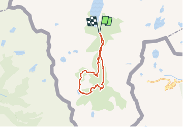
![](/images/other/stat-length.png)
![Randonnée Marche Auzat - Pyrénées-120911(gps!!!+foEnC) - Soucarrane-Roumazet - Photo](https://media.geolcdn.com/t/1900/400/ext.pjpeg?maxdim=2&url=https%3A%2F%2Fservices.sitytrail.com%2FGeolivesWS%2FDownloadMedia.ashx%3FTrailID%3D154213%26Media%3D20120911154949.jpeg)
Pyrénées-120911(gps!!!+foEnC) - Soucarrane-Roumazet
randodan
Utilisateur
![Longueur](/images/other/stat-length.png)
![Altitude max](https://static1.geolcdn.com/siteimages/upload/files/1508320355ic_sort_altitude_max_24dp.png)
![Dénivelé positif](https://static1.geolcdn.com/siteimages/upload/files/1508320355ic_sort_den_pos_24dp.png)
![Km-Effort](/images/other/stat-length.png)
![Altitude min](https://static1.geolcdn.com/siteimages/upload/files/1508320355ic_sort_altitude_min_24dp.png)
![Dénivelé négatif](https://static1.geolcdn.com/siteimages/upload/files/1508320355ic_sort_den_neg_24dp.png)
![Boucle](https://static1.geolcdn.com/siteimages/upload/files/16400158638029165_repeat_loop_refresh_sync_direction_icon.png)
![Marche](https://static1.geolcdn.com/sitytour/trail-icons/101.png)
6h24
Difficulté : Moyen
![Scannez ce code QR pour ouvrir la randonnée dans l'application SityTrail](https://capi.geolives.com/qq0zvz2zws4bq2lad0pu/sitytour/trails/154213/qr.png?size=200)
Application GPS de randonnée GRATUITE
À propos
Randonnée Marche de 14,6 km à découvrir à Occitanie, Ariège, Auzat. Cette randonnée est proposée par randodan.
Description
2012 - Camp de base : Vicdessos - 11 sep -<br>
Étangs de la Soucarrane et de Roumazet (boucle).<br>
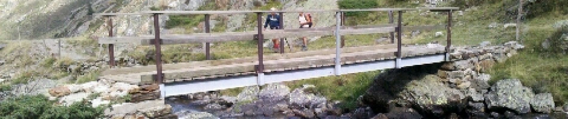
Départ parking près des Orris du Carla (1640 m) 9h20 . 10h, 1790 m, sous la Cascade de Labinas, aurait mieux fallu prendre la passerelle comme indiqué ;o).<br>
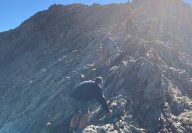
11h, 1850 m, attaquons la grimpette . A 2250 m, peu avant les orris de la Soucarrane, une brebis morte.<br>
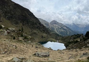
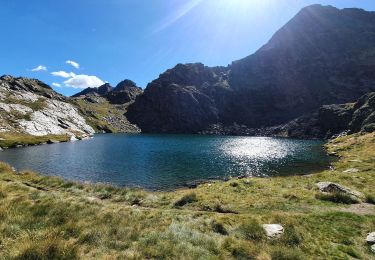
12h40, 2292 m, on s´installe pique-niquer au bord de l’Étang de la Soucarrane.<br>
13h15, on en repart (mais il y aura un petit pas d’escalade au ras de l´étang) . 14h10, 2163 m, petite pause à l´Étang de Roumazet, un groupe de 11 randonneurs itinérants nous double . Descente un peu aérienne entre 1950 et 1900 m.<br>
15h10, 1825 m, avons rejoint le sentier du vallon de Soulcem . 16h15 à la voiture.<br>
D JL Dan.<br>
Nota : dans le vallon du Soulcem, le GPS a lamentablement cafouillé, ai dû sérieusement corriger le tracé de descente .
Localisation
Commentaires
Randonnées à proximité
![Randonnée Marche Auzat - Le Picot - Photo](https://media.geolcdn.com/t/375/260/ext.jpg?maxdim=2&url=https%3A%2F%2Fservices.sitytrail.com%2FGeolivesWS%2FDownloadMedia.ashx%3FTrailID%3D218307%26Media%3D7d32352a-7ee3-4817-a78f-8417168ce812.JPG)
![Marche Marche](https://static1.geolcdn.com/sitytour/trail-icons/101.png)
![Randonnée Marche Auzat - Les étangs de la Gardelle - Auzat - Photo](https://media.geolcdn.com/t/375/260/ext.jpg?maxdim=2&url=https%3A%2F%2Fstatic1.geolcdn.com%2Fsiteimages%2Fupload%2Ffiles%2F1553511878bg_sport_marche.png)
![Marche Marche](https://static1.geolcdn.com/sitytour/trail-icons/101.png)
Marche
![](/images/other/stat-length.png)
![](https://static1.geolcdn.com/siteimages/upload/files/16400158638029165_repeat_loop_refresh_sync_direction_icon.png)
![Marche Marche](https://static1.geolcdn.com/sitytour/trail-icons/101.png)
![Randonnée sport - Arcalis - Photo](https://media.geolcdn.com/t/375/260/04058f44-9f8f-463f-a1cc-559cb86b42ee.jpg&format=jpg&maxdim=2)
![Randonnée Marche Auzat - Domaine de Montcalm -port Rat Pic Rouge - Photo](https://media.geolcdn.com/t/375/260/4ee9492f-31eb-4d1a-b77c-878ac1f5c4df.jpg&format=jpg&maxdim=2)
![Marche Marche](https://static1.geolcdn.com/sitytour/trail-icons/101.png)
Marche
![](/images/other/stat-length.png)
![](https://static1.geolcdn.com/siteimages/upload/files/16400158638029165_repeat_loop_refresh_sync_direction_icon.png)
![Randonnée Marche Auzat - Tour des lacs - Sarroucanes - Photo](https://media.geolcdn.com/t/375/260/45e48d9e-2f03-4378-bfe0-01a4ae1719c1.jpg&format=jpg&maxdim=2)
![Marche Marche](https://static1.geolcdn.com/sitytour/trail-icons/101.png)
Marche
![](/images/other/stat-length.png)
![](https://static1.geolcdn.com/siteimages/upload/files/16400158638029165_repeat_loop_refresh_sync_direction_icon.png)
![Randonnée Marche Auzat - Caraussans - Photo](https://media.geolcdn.com/t/375/260/13f3c7b9-396a-4438-ab57-e6debb7e127e.jpg&format=jpg&maxdim=2)
![Marche Marche](https://static1.geolcdn.com/sitytour/trail-icons/101.png)
Marche
![](/images/other/stat-length.png)
![](https://static1.geolcdn.com/siteimages/upload/files/16400158638029165_repeat_loop_refresh_sync_direction_icon.png)
![Randonnée Marche Auzat - Boucle etangs de la Gardelle - Photo](https://media.geolcdn.com/t/375/260/fb25dd7f-b9c3-45ab-85f7-b885de72aafa.jpg&format=jpg&maxdim=2)
![Marche Marche](https://static1.geolcdn.com/sitytour/trail-icons/101.png)
Marche
![](/images/other/stat-length.png)
![](https://static1.geolcdn.com/siteimages/upload/files/16400158638029165_repeat_loop_refresh_sync_direction_icon.png)
![Randonnée Marche Auzat - Fourcat - Photo](https://media.geolcdn.com/t/375/260/1246df19-c72a-49ce-9f67-6435cfda3815.jpg&format=jpg&maxdim=2)
![Marche Marche](https://static1.geolcdn.com/sitytour/trail-icons/101.png)