![](/images/other/stat-length.png)
![Randonnée V.T.T. Montigny-le-Bretonneux - Rando Les Renards 50k - Photo](https://media.geolcdn.com/t/1900/400/ext.pjpeg?maxdim=2&url=https%3A%2F%2Fstatic1.geolcdn.com%2Fsiteimages%2Fupload%2Ffiles%2F1524743154velo.jpg)
Rando Les Renards 50k
guariso
Utilisateur
![Longueur](/images/other/stat-length.png)
Longueur
51 km
![Altitude max](https://static1.geolcdn.com/siteimages/upload/files/1508320355ic_sort_altitude_max_24dp.png)
Altitude max
183 m
![Dénivelé positif](https://static1.geolcdn.com/siteimages/upload/files/1508320355ic_sort_den_pos_24dp.png)
Dénivelé positif
913 m
![Km-Effort](/images/other/stat-length.png)
Km-Effort
64 km
![Altitude min](https://static1.geolcdn.com/siteimages/upload/files/1508320355ic_sort_altitude_min_24dp.png)
Altitude min
91 m
![Dénivelé négatif](https://static1.geolcdn.com/siteimages/upload/files/1508320355ic_sort_den_neg_24dp.png)
Dénivelé négatif
914 m
![Boucle](https://static1.geolcdn.com/siteimages/upload/files/16400158638029165_repeat_loop_refresh_sync_direction_icon.png)
Boucle
Oui
Date de création :
2014-12-10 00:00:00.0
Dernière modification :
2014-12-10 00:00:00.0
![V.T.T.](https://static1.geolcdn.com/sitytour/trail-icons/202.png)
4h00
Difficulté : Difficile
![Scannez ce code QR pour ouvrir la randonnée dans l'application SityTrail](https://capi.geolives.com/qq0zvz2zws4bq2lad0pu/sitytour/trails/153020/qr.png?size=200)
Application GPS de randonnée GRATUITE
À propos
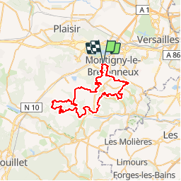
Randonnée V.T.T. de 51 km à découvrir à Île-de-France, Yvelines, Montigny-le-Bretonneux. Cette randonnée est proposée par guariso.
Description
Randonnée organisée par le vélo club de Montigny le Bx "Les Renards" le 9/9/2012, à prendre dans le sens des aiguilles d'une montre.
Localisation
Pays :
France
Région :
Île-de-France
Département/Province :
Yvelines
Commune :
Montigny-le-Bretonneux
Localité :
Unknown
Départ:(Dec)
Départ:(UTM)
427980 ; 5402635 (31U) N.
Commentaires
Randonnées à proximité
![Randonnée Marche Magny-les-Hameaux - _La Vallée de la Mérantaise - Photo](https://media.geolcdn.com/t/375/260/ext.jpg?maxdim=2&url=https%3A%2F%2Fservices.sitytrail.com%2FGeolivesWS%2FDownloadMedia.ashx%3FTrailID%3D755616%26Media%3Deae23003-4ad7-4454-b083-3d96818374a8.jpg)
![Marche Marche](https://static1.geolcdn.com/sitytour/trail-icons/101.png)
_La Vallée de la Mérantaise
Marche
Facile
(5)
Magny-les-Hameaux,
Île-de-France,
Yvelines,
France
![](/images/other/stat-length.png)
9,7 km | 11,6 km-effort
2h 30min
![](https://static1.geolcdn.com/siteimages/upload/files/16400158638029165_repeat_loop_refresh_sync_direction_icon.png)
Oui
![Randonnée Marche Le Mesnil-Saint-Denis - _Entre ancienne châtellenie et Ville nouvelle - Photo](https://media.geolcdn.com/t/375/260/ext.jpg?maxdim=2&url=https%3A%2F%2Fservices.sitytrail.com%2FGeolivesWS%2FDownloadMedia.ashx%3FTrailID%3D754427%26Media%3D98bcb1fa-3e08-461c-9cfd-0202e71bacca.png)
![Marche Marche](https://static1.geolcdn.com/sitytour/trail-icons/101.png)
_Entre ancienne châtellenie et Ville nouvelle
Marche
Facile
(1)
Le Mesnil-Saint-Denis,
Île-de-France,
Yvelines,
France
![](/images/other/stat-length.png)
8,6 km | 9,5 km-effort
2h 30min
![](https://static1.geolcdn.com/siteimages/upload/files/16400158638029165_repeat_loop_refresh_sync_direction_icon.png)
Oui
![Randonnée Marche Saint-Lambert - _Sur les pas de Racine (deuxième partie) - Photo](https://media.geolcdn.com/t/375/260/ext.jpg?maxdim=2&url=https%3A%2F%2Fservices.sitytrail.com%2FGeolivesWS%2FDownloadMedia.ashx%3FTrailID%3D745749%26Media%3Db1edb432-b6c8-43f7-9f4b-66b807e05156.jpg)
![Marche Marche](https://static1.geolcdn.com/sitytour/trail-icons/101.png)
_Sur les pas de Racine (deuxième partie)
Marche
Facile
(2)
Saint-Lambert,
Île-de-France,
Yvelines,
France
![](/images/other/stat-length.png)
10,5 km | 12,5 km-effort
2h 30min
![](https://static1.geolcdn.com/siteimages/upload/files/16400158638029165_repeat_loop_refresh_sync_direction_icon.png)
Oui
![Randonnée Marche Magny-les-Hameaux - Merantaise réel - Photo](https://media.geolcdn.com/t/375/260/4d2164f2-d361-4db7-b056-eb385e9bacad.jpeg&format=jpg&maxdim=2)
![Marche Marche](https://static1.geolcdn.com/sitytour/trail-icons/101.png)
Merantaise réel
Marche
Difficile
(1)
Magny-les-Hameaux,
Île-de-France,
Yvelines,
France
![](/images/other/stat-length.png)
11,3 km | 14,2 km-effort
3h 18min
![](https://static1.geolcdn.com/siteimages/upload/files/16400158638029165_repeat_loop_refresh_sync_direction_icon.png)
Oui
![Randonnée Marche Magny-les-Hameaux - Boucle 23 km à partir de Port Royal des Champs - Photo](https://media.geolcdn.com/t/375/260/9a76b572-9029-4a25-99b4-82cf64e08344.jpg&format=jpg&maxdim=2)
![Marche Marche](https://static1.geolcdn.com/sitytour/trail-icons/101.png)
Boucle 23 km à partir de Port Royal des Champs
Marche
Facile
Magny-les-Hameaux,
Île-de-France,
Yvelines,
France
![](/images/other/stat-length.png)
23 km | 28 km-effort
4h 56min
![](https://static1.geolcdn.com/siteimages/upload/files/16400158638029165_repeat_loop_refresh_sync_direction_icon.png)
Oui
![Randonnée V.T.T. Saint-Cyr-l'École - 14102013 - Photo](https://media.geolcdn.com/t/375/260/ext.jpg?maxdim=2&url=https%3A%2F%2Fstatic1.geolcdn.com%2Fsiteimages%2Fupload%2Ffiles%2F1524743154velo.jpg)
![V.T.T. V.T.T.](https://static1.geolcdn.com/sitytour/trail-icons/202.png)
14102013
V.T.T.
Moyen
(1)
Saint-Cyr-l'École,
Île-de-France,
Yvelines,
France
![](/images/other/stat-length.png)
42 km | 50 km-effort
3h 11min
![](https://static1.geolcdn.com/siteimages/upload/files/16400158638029165_repeat_loop_refresh_sync_direction_icon.png)
Oui
![Randonnée V.T.T. Montigny-le-Bretonneux - Rando des renards 35k - Photo](https://media.geolcdn.com/t/375/260/ext.jpg?maxdim=2&url=https%3A%2F%2Fstatic1.geolcdn.com%2Fsiteimages%2Fupload%2Ffiles%2F1524743154velo.jpg)
![V.T.T. V.T.T.](https://static1.geolcdn.com/sitytour/trail-icons/202.png)
Rando des renards 35k
V.T.T.
Moyen
(1)
Montigny-le-Bretonneux,
Île-de-France,
Yvelines,
France
![](/images/other/stat-length.png)
38 km | 46 km-effort
2h 50min
![](https://static1.geolcdn.com/siteimages/upload/files/16400158638029165_repeat_loop_refresh_sync_direction_icon.png)
Oui
![Randonnée sport Saint-Lambert - Balade Chevreuse - Photo](https://media.geolcdn.com/t/375/260/e72ebaec-ed2d-40a4-87cd-15a387dcd994.jpg&format=jpg&maxdim=2)
Balade Chevreuse
sport
Très facile
Saint-Lambert,
Île-de-France,
Yvelines,
France
![](/images/other/stat-length.png)
12 km | 15,8 km-effort
Inconnu
![](https://static1.geolcdn.com/siteimages/upload/files/16400158638029165_repeat_loop_refresh_sync_direction_icon.png)
Oui
![Randonnée Course à pied Voisins-le-Bretonneux - domaine d'Or - Photo](https://media.geolcdn.com/t/375/260/cd206760-3d6b-4c1c-979c-7a5d20ed9e8c.jpg&format=jpg&maxdim=2)
![Course à pied Course à pied](https://static1.geolcdn.com/sitytour/trail-icons/103.png)
domaine d'Or
Course à pied
Moyen
Voisins-le-Bretonneux,
Île-de-France,
Yvelines,
France
![](/images/other/stat-length.png)
17,3 km | 19,7 km-effort
2h 53min
![](https://static1.geolcdn.com/siteimages/upload/files/16400158638029165_repeat_loop_refresh_sync_direction_icon.png)
Oui