![](/images/other/stat-length.png)
![Randonnée Marche Plouha - Gwin Zegal - Photo](https://media.geolcdn.com/t/1900/400/ext.pjpeg?maxdim=2&url=https%3A%2F%2Fstatic1.geolcdn.com%2Fsiteimages%2Fupload%2Ffiles%2F1553511878bg_sport_marche.png)
Gwin Zegal
kronio
Utilisateur
![Longueur](/images/other/stat-length.png)
Longueur
5,3 km
![Altitude max](https://static1.geolcdn.com/siteimages/upload/files/1508320355ic_sort_altitude_max_24dp.png)
Altitude max
108 m
![Dénivelé positif](https://static1.geolcdn.com/siteimages/upload/files/1508320355ic_sort_den_pos_24dp.png)
Dénivelé positif
111 m
![Km-Effort](/images/other/stat-length.png)
Km-Effort
6,8 km
![Altitude min](https://static1.geolcdn.com/siteimages/upload/files/1508320355ic_sort_altitude_min_24dp.png)
Altitude min
26 m
![Dénivelé négatif](https://static1.geolcdn.com/siteimages/upload/files/1508320355ic_sort_den_neg_24dp.png)
Dénivelé négatif
110 m
![Boucle](https://static1.geolcdn.com/siteimages/upload/files/16400158638029165_repeat_loop_refresh_sync_direction_icon.png)
Boucle
Oui
Date de création :
2014-12-10 00:00:00.0
Dernière modification :
2014-12-10 00:00:00.0
![Marche](https://static1.geolcdn.com/sitytour/trail-icons/101.png)
1h56
Difficulté : Inconnu
![Scannez ce code QR pour ouvrir la randonnée dans l'application SityTrail](https://capi.geolives.com/qq0zvz2zws4bq2lad0pu/sitytour/trails/152947/qr.png?size=200)
Application GPS de randonnée GRATUITE
À propos
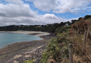
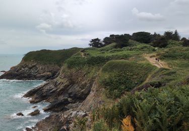
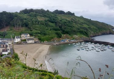
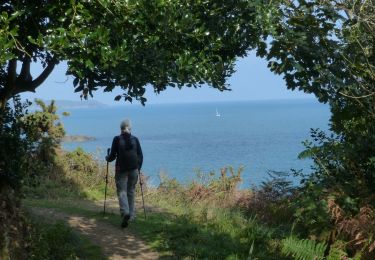
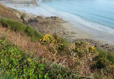
Randonnée Marche de 5,3 km à découvrir à Bretagne, Côtes-d'Armor, Plouha. Cette randonnée est proposée par kronio.
Description
Une partie le long des falaises du GR34 et à la pointe de plouha on retourne par l'intérieur des terres pour rajouandre le parking de Gwin Zegal
Localisation
Pays :
France
Région :
Bretagne
Département/Province :
Côtes-d'Armor
Commune :
Plouha
Localité :
Unknown
Départ:(Dec)
Départ:(UTM)
507631 ; 5393804 (30U) N.
Commentaires
Randonnées à proximité
![Randonnée Marche Tréveneuc - Tréveneuc Chapelle Saint-Marc - GR34 Plage de la Banche - 24.8km 420m 5h35 (40mn) - 2024 07 03 - Photo](https://media.geolcdn.com/t/375/260/51710ac1-2892-4699-8de2-befb83d8a9f9.jpg&format=jpg&maxdim=2)
![Marche Marche](https://static1.geolcdn.com/sitytour/trail-icons/101.png)
Tréveneuc Chapelle Saint-Marc - GR34 Plage de la Banche - 24.8km 420m 5h35 (4...
Marche
Difficile
Tréveneuc,
Bretagne,
Côtes-d'Armor,
France
![](/images/other/stat-length.png)
25 km | 30 km-effort
5h 35min
![](https://static1.geolcdn.com/siteimages/upload/files/16400158638029165_repeat_loop_refresh_sync_direction_icon.png)
Oui
![Randonnée Marche Plouha - Plouha Plage Bonaparte - GR34 Chapelle Saint-Marc - 22.9km 465m 5h20 (35mn) - 2024 07 02 - Photo](https://media.geolcdn.com/t/375/260/bcacf27c-29c4-44ac-9acd-40f1f30e3463.jpg&format=jpg&maxdim=2)
![Marche Marche](https://static1.geolcdn.com/sitytour/trail-icons/101.png)
Plouha Plage Bonaparte - GR34 Chapelle Saint-Marc - 22.9km 465m 5h20 (35mn) -...
Marche
Difficile
Plouha,
Bretagne,
Côtes-d'Armor,
France
![](/images/other/stat-length.png)
23 km | 29 km-effort
5h 20min
![](https://static1.geolcdn.com/siteimages/upload/files/16400158638029165_repeat_loop_refresh_sync_direction_icon.png)
Oui
![Randonnée Marche Plouha - GR_34_CG_20_Plouha_Plouezec_20240528 - Photo](https://media.geolcdn.com/t/375/260/1c219358-8314-48f4-beed-23d75278c8e8.jpg&format=jpg&maxdim=2)
![Marche Marche](https://static1.geolcdn.com/sitytour/trail-icons/101.png)
GR_34_CG_20_Plouha_Plouezec_20240528
Marche
Moyen
Plouha,
Bretagne,
Côtes-d'Armor,
France
![](/images/other/stat-length.png)
12,2 km | 16,5 km-effort
3h 26min
![](https://static1.geolcdn.com/siteimages/upload/files/16400158638029165_repeat_loop_refresh_sync_direction_icon.png)
Non
![Randonnée Marche Plouha - Falaises de Plouha 9.7.23 - Photo](https://media.geolcdn.com/t/375/260/de6227f9-1985-40a8-bc72-346614fcac6d.jpg&format=jpg&maxdim=2)
![Marche Marche](https://static1.geolcdn.com/sitytour/trail-icons/101.png)
Falaises de Plouha 9.7.23
Marche
Facile
Plouha,
Bretagne,
Côtes-d'Armor,
France
![](/images/other/stat-length.png)
14,8 km | 20 km-effort
2h 50min
![](https://static1.geolcdn.com/siteimages/upload/files/16400158638029165_repeat_loop_refresh_sync_direction_icon.png)
Non
![Randonnée A pied Plouha - Les Trois Chapelles - Photo](https://media.geolcdn.com/t/375/260/9df4f58f-9bc5-4b98-9444-d236d8a979ac.jpeg&format=jpg&maxdim=2)
![A pied A pied](https://static1.geolcdn.com/sitytour/trail-icons/100.png)
Les Trois Chapelles
A pied
Facile
Plouha,
Bretagne,
Côtes-d'Armor,
France
![](/images/other/stat-length.png)
7,6 km | 8,4 km-effort
1h 54min
![](https://static1.geolcdn.com/siteimages/upload/files/16400158638029165_repeat_loop_refresh_sync_direction_icon.png)
Oui
![Randonnée Marche Plouha - plouha plage Bonaparte 5km - Photo](https://media.geolcdn.com/t/375/260/78cdae15-3218-4374-930c-e7dd702ed49a.jpg&format=jpg&maxdim=2)
![Marche Marche](https://static1.geolcdn.com/sitytour/trail-icons/101.png)
plouha plage Bonaparte 5km
Marche
Très difficile
Plouha,
Bretagne,
Côtes-d'Armor,
France
![](/images/other/stat-length.png)
24 km | 28 km-effort
3h 6min
![](https://static1.geolcdn.com/siteimages/upload/files/16400158638029165_repeat_loop_refresh_sync_direction_icon.png)
Non
![Marche Marche](https://static1.geolcdn.com/sitytour/trail-icons/101.png)
Falaises de Plouha
Marche
Moyen
(1)
Plouha,
Bretagne,
Côtes-d'Armor,
France
![](/images/other/stat-length.png)
16,2 km | 21 km-effort
5h 44min
![](https://static1.geolcdn.com/siteimages/upload/files/16400158638029165_repeat_loop_refresh_sync_direction_icon.png)
Oui
![Randonnée Marche Plouha - A 13 De la Plage Bonaparte - Photo](https://media.geolcdn.com/t/375/260/ext.jpg?maxdim=2&url=https%3A%2F%2Fservices.sitytrail.com%2FGeolivesWS%2FDownloadMedia.ashx%3FTrailID%3D713320%26Media%3D11a2245f-cb53-4f40-8ca7-531c568f816d.jpg)
![Marche Marche](https://static1.geolcdn.com/sitytour/trail-icons/101.png)
A 13 De la Plage Bonaparte
Marche
Très facile
Plouha,
Bretagne,
Côtes-d'Armor,
France
![](/images/other/stat-length.png)
15,4 km | 19,7 km-effort
4h 21min
![](https://static1.geolcdn.com/siteimages/upload/files/16400158638029165_repeat_loop_refresh_sync_direction_icon.png)
Oui
![Randonnée Marche Saint-Quay-Portrieux - GR 34 étape 18 - Photo](https://media.geolcdn.com/t/375/260/ext.jpg?maxdim=2&url=https%3A%2F%2Fservices.sitytrail.com%2FGeolivesWS%2FDownloadMedia.ashx%3FTrailID%3D271059%26Media%3Dfix__20140424095302.jpg)
![Marche Marche](https://static1.geolcdn.com/sitytour/trail-icons/101.png)
GR 34 étape 18
Marche
Facile
Saint-Quay-Portrieux,
Bretagne,
Côtes-d'Armor,
France
![](/images/other/stat-length.png)
31 km | 41 km-effort
8h 33min
![](https://static1.geolcdn.com/siteimages/upload/files/16400158638029165_repeat_loop_refresh_sync_direction_icon.png)
Non