![](/images/other/stat-length.png)
![Randonnée Marche Champagney - Puits de mines Ronchamp - Photo](https://media.geolcdn.com/t/1900/400/ext.pjpeg?maxdim=2&url=https%3A%2F%2Fstatic1.geolcdn.com%2Fsiteimages%2Fupload%2Ffiles%2F1553511878bg_sport_marche.png)
Puits de mines Ronchamp
ballet
Utilisateur
![Longueur](/images/other/stat-length.png)
Longueur
21 km
![Altitude max](https://static1.geolcdn.com/siteimages/upload/files/1508320355ic_sort_altitude_max_24dp.png)
Altitude max
587 m
![Dénivelé positif](https://static1.geolcdn.com/siteimages/upload/files/1508320355ic_sort_den_pos_24dp.png)
Dénivelé positif
605 m
![Km-Effort](/images/other/stat-length.png)
Km-Effort
29 km
![Altitude min](https://static1.geolcdn.com/siteimages/upload/files/1508320355ic_sort_altitude_min_24dp.png)
Altitude min
338 m
![Dénivelé négatif](https://static1.geolcdn.com/siteimages/upload/files/1508320355ic_sort_den_neg_24dp.png)
Dénivelé négatif
606 m
![Boucle](https://static1.geolcdn.com/siteimages/upload/files/16400158638029165_repeat_loop_refresh_sync_direction_icon.png)
Boucle
Oui
Date de création :
2014-12-10 00:00:00.0
Dernière modification :
2014-12-10 00:00:00.0
![Marche](https://static1.geolcdn.com/sitytour/trail-icons/101.png)
5h00
Difficulté : Moyen
![Scannez ce code QR pour ouvrir la randonnée dans l'application SityTrail](https://capi.geolives.com/qq0zvz2zws4bq2lad0pu/sitytour/trails/152226/qr.png?size=200)
Application GPS de randonnée GRATUITE
À propos
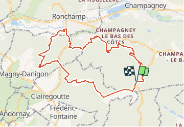
Randonnée Marche de 21 km à découvrir à Bourgogne-Franche-Comté, Haute-Saône, Champagney. Cette randonnée est proposée par ballet.
Description
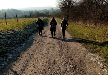
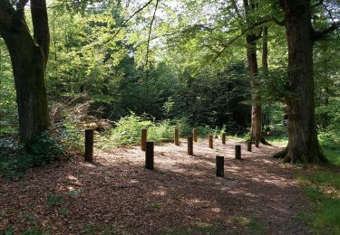
Marche assez facile car pas beaucoup de dénivelé. La difficulté qui fait son attrait est de trouver les innombrables anciens puits de mines sur ce circuit.
Localisation
Pays :
France
Région :
Bourgogne-Franche-Comté
Département/Province :
Haute-Saône
Commune :
Champagney
Localité :
Unknown
Départ:(Dec)
Départ:(UTM)
325737 ; 5282224 (32T) N.
Commentaires
Randonnées à proximité
![Randonnée Marche Ronchamp - le tour par la chapelle Ronchamp - Photo](https://media.geolcdn.com/t/375/260/ext.jpg?maxdim=2&url=https%3A%2F%2Fservices.sitytrail.com%2FGeolivesWS%2FDownloadMedia.ashx%3FTrailID%3D200144%26Media%3D20130623170833.jpeg)
![Marche Marche](https://static1.geolcdn.com/sitytour/trail-icons/101.png)
le tour par la chapelle Ronchamp
Marche
Facile
(1)
Ronchamp,
Bourgogne-Franche-Comté,
Haute-Saône,
France
![](/images/other/stat-length.png)
4,2 km | 5,8 km-effort
1h 16min
![](https://static1.geolcdn.com/siteimages/upload/files/16400158638029165_repeat_loop_refresh_sync_direction_icon.png)
Oui
![Randonnée Marche Belverne - Belverne - grotte des prisonniers allemands - Etobon - Photo](https://media.geolcdn.com/t/375/260/672bce46-e385-463a-848a-615cbdc257e6.jpg&format=jpg&maxdim=2)
![Marche Marche](https://static1.geolcdn.com/sitytour/trail-icons/101.png)
Belverne - grotte des prisonniers allemands - Etobon
Marche
Moyen
Belverne,
Bourgogne-Franche-Comté,
Haute-Saône,
France
![](/images/other/stat-length.png)
15 km | 21 km-effort
2h 56min
![](https://static1.geolcdn.com/siteimages/upload/files/16400158638029165_repeat_loop_refresh_sync_direction_icon.png)
Oui
![Randonnée Marche Ronchamp - Ronchamp - Chapelle ND du Haut - sentier de l'Etançon (puits de mines) - Photo](https://media.geolcdn.com/t/375/260/17f2d8a4-0385-46eb-a4ac-833c4b43d439.jpg&format=jpg&maxdim=2)
![Marche Marche](https://static1.geolcdn.com/sitytour/trail-icons/101.png)
Ronchamp - Chapelle ND du Haut - sentier de l'Etançon (puits de mines)
Marche
Difficile
Ronchamp,
Bourgogne-Franche-Comté,
Haute-Saône,
France
![](/images/other/stat-length.png)
10,3 km | 13,6 km-effort
3h 5min
![](https://static1.geolcdn.com/siteimages/upload/files/16400158638029165_repeat_loop_refresh_sync_direction_icon.png)
Oui
![Randonnée Marche Champagney - Canal souterrain de la Haute-Saône - Photo](https://media.geolcdn.com/t/375/260/04c8dd3d-861a-49bc-aa06-88e783162bdc.jpg&format=jpg&maxdim=2)
![Marche Marche](https://static1.geolcdn.com/sitytour/trail-icons/101.png)
Canal souterrain de la Haute-Saône
Marche
Difficile
Champagney,
Bourgogne-Franche-Comté,
Haute-Saône,
France
![](/images/other/stat-length.png)
10,1 km | 13,4 km-effort
3h 3min
![](https://static1.geolcdn.com/siteimages/upload/files/16400158638029165_repeat_loop_refresh_sync_direction_icon.png)
Oui
![Randonnée Marche Frahier-et-Chatebier - frahier - Photo](https://media.geolcdn.com/t/375/260/95f0d94d-e209-4293-8856-d410c2620589.jpg&format=jpg&maxdim=2)
![Marche Marche](https://static1.geolcdn.com/sitytour/trail-icons/101.png)
frahier
Marche
Moyen
(1)
Frahier-et-Chatebier,
Bourgogne-Franche-Comté,
Haute-Saône,
France
![](/images/other/stat-length.png)
5,6 km | 6,8 km-effort
1h 44min
![](https://static1.geolcdn.com/siteimages/upload/files/16400158638029165_repeat_loop_refresh_sync_direction_icon.png)
Oui
![Randonnée Marche Champagney - Champagney - canal de la Haute-Saône - tunnel - Photo](https://media.geolcdn.com/t/375/260/53752e24-7a78-44c3-b746-8236e26bab64.jpg&format=jpg&maxdim=2)
![Marche Marche](https://static1.geolcdn.com/sitytour/trail-icons/101.png)
Champagney - canal de la Haute-Saône - tunnel
Marche
Moyen
Champagney,
Bourgogne-Franche-Comté,
Haute-Saône,
France
![](/images/other/stat-length.png)
5,5 km | 7,5 km-effort
1h 10min
![](https://static1.geolcdn.com/siteimages/upload/files/16400158638029165_repeat_loop_refresh_sync_direction_icon.png)
Oui
![Randonnée Marche Champagney - Grotte prisonniers allemands - château Etobon - Etobon - Photo](https://media.geolcdn.com/t/375/260/f76125a8-85be-43f8-b3b5-d887afc7fd40.jpg&format=jpg&maxdim=2)
![Marche Marche](https://static1.geolcdn.com/sitytour/trail-icons/101.png)
Grotte prisonniers allemands - château Etobon - Etobon
Marche
Moyen
(1)
Champagney,
Bourgogne-Franche-Comté,
Haute-Saône,
France
![](/images/other/stat-length.png)
15 km | 22 km-effort
4h 36min
![](https://static1.geolcdn.com/siteimages/upload/files/16400158638029165_repeat_loop_refresh_sync_direction_icon.png)
Oui
![Randonnée Marche Étobon - Etobon - Photo](https://media.geolcdn.com/t/375/260/ext.jpg?maxdim=2&url=https%3A%2F%2Fstatic1.geolcdn.com%2Fsiteimages%2Fupload%2Ffiles%2F1553511878bg_sport_marche.png)
![Marche Marche](https://static1.geolcdn.com/sitytour/trail-icons/101.png)
Etobon
Marche
Très facile
(2)
Étobon,
Bourgogne-Franche-Comté,
Haute-Saône,
France
![](/images/other/stat-length.png)
8,9 km | 12,8 km-effort
4h 0min
![](https://static1.geolcdn.com/siteimages/upload/files/16400158638029165_repeat_loop_refresh_sync_direction_icon.png)
Oui
![Randonnée Marche Champagney - parcours sportif des Épaisses à Champagney - Photo](https://media.geolcdn.com/t/375/260/5ea0a359-1d7e-46eb-81bb-44044f5bf7c9.jpg&format=jpg&maxdim=2)
![Marche Marche](https://static1.geolcdn.com/sitytour/trail-icons/101.png)
parcours sportif des Épaisses à Champagney
Marche
Facile
Champagney,
Bourgogne-Franche-Comté,
Haute-Saône,
France
![](/images/other/stat-length.png)
1,7 km | 2 km-effort
36min
![](https://static1.geolcdn.com/siteimages/upload/files/16400158638029165_repeat_loop_refresh_sync_direction_icon.png)
Oui