![](/images/other/stat-length.png)
![Randonnée Marche La Seyne-sur-Mer - VLT 2114 Plages en 1° Cap Sicié, depuis Fabrégas - Photo](https://media.geolcdn.com/t/1900/400/ext.pjpeg?maxdim=2&url=https%3A%2F%2Fstatic1.geolcdn.com%2Fsiteimages%2Fupload%2Ffiles%2F1553511878bg_sport_marche.png)
VLT 2114 Plages en 1° Cap Sicié, depuis Fabrégas
jmheydorff
Utilisateur
![Longueur](/images/other/stat-length.png)
![Altitude max](https://static1.geolcdn.com/siteimages/upload/files/1508320355ic_sort_altitude_max_24dp.png)
![Dénivelé positif](https://static1.geolcdn.com/siteimages/upload/files/1508320355ic_sort_den_pos_24dp.png)
![Km-Effort](/images/other/stat-length.png)
![Altitude min](https://static1.geolcdn.com/siteimages/upload/files/1508320355ic_sort_altitude_min_24dp.png)
![Dénivelé négatif](https://static1.geolcdn.com/siteimages/upload/files/1508320355ic_sort_den_neg_24dp.png)
![Boucle](https://static1.geolcdn.com/siteimages/upload/files/16400158638029165_repeat_loop_refresh_sync_direction_icon.png)
![Marche](https://static1.geolcdn.com/sitytour/trail-icons/101.png)
4h59
Difficulté : Moyen
![Scannez ce code QR pour ouvrir la randonnée dans l'application SityTrail](https://capi.geolives.com/qq0zvz2zws4bq2lad0pu/sitytour/trails/150454/qr.png?size=200)
Application GPS de randonnée GRATUITE
À propos
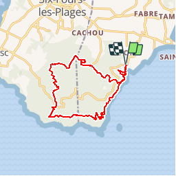
Randonnée Marche de 15,3 km à découvrir à Provence-Alpes-Côte d'Azur, Var, La Seyne-sur-Mer. Cette randonnée est proposée par jmheydorff.
Description
Pkg au rd pt de Fabrégas. On peut faire la boucle dans les 2 sens; s''il fait chaud, il vaut mieux passer par la forêt de janas le matin, et revenir en descendant le cap Sicié (attention, ne pas prendre la descente (ou la montée) de la borne 330 au Cap sicié (très pentue), de plus, le sentier est fermé vers la pointe des Jonquiers (contour possible), car le sentier du bord de mer est dangereux entre le Cap Sicié et la poinr des Jonquiers
Localisation
Commentaires
Randonnées à proximité
![Randonnée Marche Six-Fours-les-Plages - ND de Pepiole via colline du fort de Six-Fours, retour par Les Lônes - Photo](https://media.geolcdn.com/t/375/260/1379151f-75a9-4587-8d69-64d0542e06ca.jpg&format=jpg&maxdim=2)
![Marche Marche](https://static1.geolcdn.com/sitytour/trail-icons/101.png)
Marche
![](/images/other/stat-length.png)
![](https://static1.geolcdn.com/siteimages/upload/files/16400158638029165_repeat_loop_refresh_sync_direction_icon.png)
![Randonnée Marche Six-Fours-les-Plages - ND de Pepiole via colline du fort de Six-Fours - Photo](https://media.geolcdn.com/t/375/260/1379151f-75a9-4587-8d69-64d0542e06ca.jpg&format=jpg&maxdim=2)
![Marche Marche](https://static1.geolcdn.com/sitytour/trail-icons/101.png)
Marche
![](/images/other/stat-length.png)
![](https://static1.geolcdn.com/siteimages/upload/files/16400158638029165_repeat_loop_refresh_sync_direction_icon.png)
![Randonnée Marche La Seyne-sur-Mer - fabregas parking du bœuf, plage des nudistes, sémaphore, notre dame de mai. - Photo](https://media.geolcdn.com/t/375/260/d2496b6d-773d-4991-9a61-fe4c8adf1522.jpg&format=jpg&maxdim=2)
![Marche Marche](https://static1.geolcdn.com/sitytour/trail-icons/101.png)
Marche
![](/images/other/stat-length.png)
![](https://static1.geolcdn.com/siteimages/upload/files/16400158638029165_repeat_loop_refresh_sync_direction_icon.png)
![Randonnée V.T.T. La Seyne-sur-Mer - Cap Sicié - Fabregas - Photo](https://media.geolcdn.com/t/375/260/ext.jpg?maxdim=2&url=https%3A%2F%2Fservices.sitytrail.com%2FGeolivesWS%2FDownloadMedia.ashx%3FTrailID%3D105841%26Media%3D9806_1.jpg)
![V.T.T. V.T.T.](https://static1.geolcdn.com/sitytour/trail-icons/202.png)
V.T.T.
![](/images/other/stat-length.png)
![](https://static1.geolcdn.com/siteimages/upload/files/16400158638029165_repeat_loop_refresh_sync_direction_icon.png)
![Randonnée Marche Toulon - Tour royale à Monaco 13 Novembre 2021 - Photo](https://media.geolcdn.com/t/375/260/d44cd298-c3f2-4c69-9481-e73635990ceb.jpg&format=jpg&maxdim=2)
![Marche Marche](https://static1.geolcdn.com/sitytour/trail-icons/101.png)
Marche
![](/images/other/stat-length.png)
![](https://static1.geolcdn.com/siteimages/upload/files/16400158638029165_repeat_loop_refresh_sync_direction_icon.png)
![Randonnée Marche Six-Fours-les-Plages - Graffitis - blockhaus - Crètes du Quicon - Dolmen de La Lèque - Roumagnan - Photo](https://media.geolcdn.com/t/375/260/e37183bf-4c1c-448c-8453-7e7135227837.jpg&format=jpg&maxdim=2)
![Marche Marche](https://static1.geolcdn.com/sitytour/trail-icons/101.png)
Marche
![](/images/other/stat-length.png)
![](https://static1.geolcdn.com/siteimages/upload/files/16400158638029165_repeat_loop_refresh_sync_direction_icon.png)
![Randonnée Marche Six-Fours-les-Plages - Cap Sicié - Notre Dame du Mai - Six fours - Photo](https://media.geolcdn.com/t/375/260/5d40a7c9-6bdb-4d87-9016-02770321b032.jpg&format=jpg&maxdim=2)
![Marche Marche](https://static1.geolcdn.com/sitytour/trail-icons/101.png)
Marche
![](/images/other/stat-length.png)
![](https://static1.geolcdn.com/siteimages/upload/files/16400158638029165_repeat_loop_refresh_sync_direction_icon.png)
![Randonnée Marche La Seyne-sur-Mer - janas - Photo](https://media.geolcdn.com/t/375/260/ext.jpg?maxdim=2&url=https%3A%2F%2Fstatic1.geolcdn.com%2Fsiteimages%2Fupload%2Ffiles%2F1553511878bg_sport_marche.png)
![Marche Marche](https://static1.geolcdn.com/sitytour/trail-icons/101.png)
Marche
![](/images/other/stat-length.png)
![](https://static1.geolcdn.com/siteimages/upload/files/16400158638029165_repeat_loop_refresh_sync_direction_icon.png)
![Randonnée Marche Saint-Mandrier-sur-Mer - Presqu'île de Saint-Mandrier - Photo](https://media.geolcdn.com/t/375/260/ext.jpg?maxdim=2&url=https%3A%2F%2Fstatic1.geolcdn.com%2Fsiteimages%2Fupload%2Ffiles%2F1553511878bg_sport_marche.png)
![Marche Marche](https://static1.geolcdn.com/sitytour/trail-icons/101.png)
Marche
![](/images/other/stat-length.png)
![](https://static1.geolcdn.com/siteimages/upload/files/16400158638029165_repeat_loop_refresh_sync_direction_icon.png)
tres bien