![](/images/other/stat-length.png)
![Randonnée Marche Jouy-en-Josas - jouy, guyancourt, les etangs - Photo](https://media.geolcdn.com/t/1900/400/ext.pjpeg?maxdim=2&url=https%3A%2F%2Fstatic1.geolcdn.com%2Fsiteimages%2Fupload%2Ffiles%2F1553511878bg_sport_marche.png)
jouy, guyancourt, les etangs
rico21
Utilisateur
![Longueur](/images/other/stat-length.png)
Longueur
18,9 km
![Altitude max](https://static1.geolcdn.com/siteimages/upload/files/1508320355ic_sort_altitude_max_24dp.png)
Altitude max
165 m
![Dénivelé positif](https://static1.geolcdn.com/siteimages/upload/files/1508320355ic_sort_den_pos_24dp.png)
Dénivelé positif
209 m
![Km-Effort](/images/other/stat-length.png)
Km-Effort
22 km
![Altitude min](https://static1.geolcdn.com/siteimages/upload/files/1508320355ic_sort_altitude_min_24dp.png)
Altitude min
89 m
![Dénivelé négatif](https://static1.geolcdn.com/siteimages/upload/files/1508320355ic_sort_den_neg_24dp.png)
Dénivelé négatif
196 m
![Boucle](https://static1.geolcdn.com/siteimages/upload/files/16400158638029165_repeat_loop_refresh_sync_direction_icon.png)
Boucle
Oui
Date de création :
2014-12-10 00:00:00.0
Dernière modification :
2014-12-10 00:00:00.0
![Marche](https://static1.geolcdn.com/sitytour/trail-icons/101.png)
1h19
Difficulté : Facile
![Scannez ce code QR pour ouvrir la randonnée dans l'application SityTrail](https://capi.geolives.com/qq0zvz2zws4bq2lad0pu/sitytour/trails/147365/qr.png?size=200)
Application GPS de randonnée GRATUITE
À propos
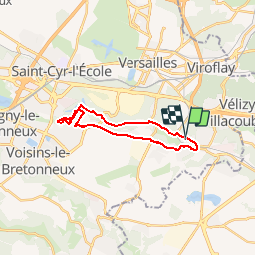
Randonnée Marche de 18,9 km à découvrir à Île-de-France, Yvelines, Jouy-en-Josas. Cette randonnée est proposée par rico21.
Description
jouy en josas, les loges en josas, guyancourt, les étangs de la minière, les étangs de la geneste, buc et jouy
Classique pour les régionaux
Localisation
Pays :
France
Région :
Île-de-France
Département/Province :
Yvelines
Commune :
Jouy-en-Josas
Localité :
Unknown
Départ:(Dec)
Départ:(UTM)
437731 ; 5402098 (31U) N.
Commentaires
Randonnées à proximité
![Randonnée Marche Chaville - Le Sentier des 7 étangs - Photo](https://media.geolcdn.com/t/375/260/ext.jpg?maxdim=2&url=https%3A%2F%2Fservices.sitytrail.com%2FGeolivesWS%2FDownloadMedia.ashx%3FTrailID%3D110203%26Media%3D5435_1.jpg)
![Marche Marche](https://static1.geolcdn.com/sitytour/trail-icons/101.png)
Le Sentier des 7 étangs
Marche
Difficile
(5)
Chaville,
Île-de-France,
Hauts-de-Seine,
France
![](/images/other/stat-length.png)
23 km | 31 km-effort
5h 0min
![](https://static1.geolcdn.com/siteimages/upload/files/16400158638029165_repeat_loop_refresh_sync_direction_icon.png)
Oui
![Randonnée Marche Jouy-en-Josas - GRP CV-IDF 19R Les Loges-en-Josas à Chaville - Photo](https://media.geolcdn.com/t/375/260/0b37f40c-1685-409c-9ec1-27f69abf4580.jpg&format=jpg&maxdim=2)
![Marche Marche](https://static1.geolcdn.com/sitytour/trail-icons/101.png)
GRP CV-IDF 19R Les Loges-en-Josas à Chaville
Marche
Difficile
(1)
Jouy-en-Josas,
Île-de-France,
Yvelines,
France
![](/images/other/stat-length.png)
11,2 km | 14,5 km-effort
3h 17min
![](https://static1.geolcdn.com/siteimages/upload/files/16400158638029165_repeat_loop_refresh_sync_direction_icon.png)
Non
![Randonnée Marche Bièvres - De Bièvres à Antony - Photo](https://media.geolcdn.com/t/375/260/ext.jpg?maxdim=2&url=https%3A%2F%2Fservices.sitytrail.com%2FGeolivesWS%2FDownloadMedia.ashx%3FTrailID%3D106789%26Media%3D11480_3.jpg)
![Marche Marche](https://static1.geolcdn.com/sitytour/trail-icons/101.png)
De Bièvres à Antony
Marche
Moyen
(1)
Bièvres,
Île-de-France,
Essonne,
France
![](/images/other/stat-length.png)
11,9 km | 14 km-effort
3h 0min
![](https://static1.geolcdn.com/siteimages/upload/files/16400158638029165_repeat_loop_refresh_sync_direction_icon.png)
Non
![Randonnée Marche Châteaufort - gitane à Chateaufort - Photo](https://media.geolcdn.com/t/375/260/ddb88f28-eed1-407a-8537-509b49789196.jpg&format=jpg&maxdim=2)
![Marche Marche](https://static1.geolcdn.com/sitytour/trail-icons/101.png)
gitane à Chateaufort
Marche
Facile
(1)
Châteaufort,
Île-de-France,
Yvelines,
France
![](/images/other/stat-length.png)
6,4 km | 7,7 km-effort
2h 3min
![](https://static1.geolcdn.com/siteimages/upload/files/16400158638029165_repeat_loop_refresh_sync_direction_icon.png)
Oui
![Randonnée Marche Jouy-en-Josas - ferme viltain - Photo](https://media.geolcdn.com/t/375/260/ext.jpg?maxdim=2&url=https%3A%2F%2Fservices.sitytrail.com%2FGeolivesWS%2FDownloadMedia.ashx%3FTrailID%3D186466%26Media%3D20130421130555.jpeg)
![Marche Marche](https://static1.geolcdn.com/sitytour/trail-icons/101.png)
ferme viltain
Marche
Très facile
(2)
Jouy-en-Josas,
Île-de-France,
Yvelines,
France
![](/images/other/stat-length.png)
9 km | 10,1 km-effort
2h 13min
![](https://static1.geolcdn.com/siteimages/upload/files/16400158638029165_repeat_loop_refresh_sync_direction_icon.png)
Oui
![Randonnée Marche Viroflay - Les 3 Forêts; Meudon, Fausses Reposes et Versailles - Photo](https://media.geolcdn.com/t/375/260/ext.jpg?maxdim=2&url=https%3A%2F%2Fservices.sitytrail.com%2FGeolivesWS%2FDownloadMedia.ashx%3FTrailID%3D110157%26Media%3D5357_1.jpg)
![Marche Marche](https://static1.geolcdn.com/sitytour/trail-icons/101.png)
Les 3 Forêts; Meudon, Fausses Reposes et Versailles
Marche
Difficile
(2)
Viroflay,
Île-de-France,
Yvelines,
France
![](/images/other/stat-length.png)
25 km | 32 km-effort
5h 19min
![](https://static1.geolcdn.com/siteimages/upload/files/16400158638029165_repeat_loop_refresh_sync_direction_icon.png)
Oui
![Randonnée Marche Chaville - Sentier des deux Forêts - Meudon et Verrières - Photo](https://media.geolcdn.com/t/375/260/ext.jpg?maxdim=2&url=https%3A%2F%2Fservices.sitytrail.com%2FGeolivesWS%2FDownloadMedia.ashx%3FTrailID%3D110156%26Media%3D5356_1.jpg)
![Marche Marche](https://static1.geolcdn.com/sitytour/trail-icons/101.png)
Sentier des deux Forêts - Meudon et Verrières
Marche
Difficile
(2)
Chaville,
Île-de-France,
Hauts-de-Seine,
France
![](/images/other/stat-length.png)
23 km | 29 km-effort
5h 0min
![](https://static1.geolcdn.com/siteimages/upload/files/16400158638029165_repeat_loop_refresh_sync_direction_icon.png)
Oui
![Randonnée Marche Buc - Le Tour de Satory - Photo](https://media.geolcdn.com/t/375/260/ext.jpg?maxdim=2&url=https%3A%2F%2Fservices.sitytrail.com%2FGeolivesWS%2FDownloadMedia.ashx%3FTrailID%3D110070%26Media%3D5206_1.jpg)
![Marche Marche](https://static1.geolcdn.com/sitytour/trail-icons/101.png)
Le Tour de Satory
Marche
Difficile
(2)
Buc,
Île-de-France,
Yvelines,
France
![](/images/other/stat-length.png)
23 km | 28 km-effort
4h 49min
![](https://static1.geolcdn.com/siteimages/upload/files/16400158638029165_repeat_loop_refresh_sync_direction_icon.png)
Oui
![Randonnée Marche Bièvres - Autour de Bièvres - Photo](https://media.geolcdn.com/t/375/260/ext.jpg?maxdim=2&url=https%3A%2F%2Fservices.sitytrail.com%2FGeolivesWS%2FDownloadMedia.ashx%3FTrailID%3D102999%26Media%3D4541_2.jpg)
![Marche Marche](https://static1.geolcdn.com/sitytour/trail-icons/101.png)
Autour de Bièvres
Marche
Moyen
(4)
Bièvres,
Île-de-France,
Essonne,
France
![](/images/other/stat-length.png)
7,6 km | 9,4 km-effort
2h 30min
![](https://static1.geolcdn.com/siteimages/upload/files/16400158638029165_repeat_loop_refresh_sync_direction_icon.png)
Oui