![](/images/other/stat-length.png)
![Randonnée Course à pied Sainte-Austreberthe - Hivernale du Raid Normand - Photo](https://media.geolcdn.com/t/1900/400/ext.pjpeg?maxdim=2&url=https%3A%2F%2Fstatic1.geolcdn.com%2Fsiteimages%2Fupload%2Ffiles%2F1524743154running.jpg)
Hivernale du Raid Normand
hgoye
Utilisateur
![Longueur](/images/other/stat-length.png)
Longueur
48 km
![Altitude max](https://static1.geolcdn.com/siteimages/upload/files/1508320355ic_sort_altitude_max_24dp.png)
Altitude max
154 m
![Dénivelé positif](https://static1.geolcdn.com/siteimages/upload/files/1508320355ic_sort_den_pos_24dp.png)
Dénivelé positif
933 m
![Km-Effort](/images/other/stat-length.png)
Km-Effort
61 km
![Altitude min](https://static1.geolcdn.com/siteimages/upload/files/1508320355ic_sort_altitude_min_24dp.png)
Altitude min
2 m
![Dénivelé négatif](https://static1.geolcdn.com/siteimages/upload/files/1508320355ic_sort_den_neg_24dp.png)
Dénivelé négatif
1049 m
![Boucle](https://static1.geolcdn.com/siteimages/upload/files/16400158638029165_repeat_loop_refresh_sync_direction_icon.png)
Boucle
Non
Date de création :
2014-12-10 00:00:00.0
Dernière modification :
2014-12-10 00:00:00.0
![Course à pied](https://static1.geolcdn.com/sitytour/trail-icons/103.png)
10h29
Difficulté : Très difficile
![Scannez ce code QR pour ouvrir la randonnée dans l'application SityTrail](https://capi.geolives.com/qq0zvz2zws4bq2lad0pu/sitytour/trails/146915/qr.png?size=200)
Application GPS de randonnée GRATUITE
À propos
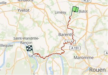
Randonnée Course à pied de 48 km à découvrir à Normandie, Seine-Maritime, Sainte-Austreberthe. Cette randonnée est proposée par hgoye.
Description
Parcours de l'hivernale du RAID Normand 2012. Parcours 42 kilomètres (à la base) qui en fait pas loin de 49 en définitive.
Points d'intérêt
Localisation
Pays :
France
Région :
Normandie
Département/Province :
Seine-Maritime
Commune :
Sainte-Austreberthe
Localité :
Unknown
Départ:(Dec)
Départ:(UTM)
353612 ; 5496163 (31U) N.
Commentaires
Randonnées à proximité
![Randonnée Marche Pavilly - 076-90-Pavilly / St Autreberthe 13.5km - Photo](https://media.geolcdn.com/t/375/260/a210e569-e658-42b2-bef9-eb8848a71140.jpg&format=jpg&maxdim=2)
![Marche Marche](https://static1.geolcdn.com/sitytour/trail-icons/101.png)
076-90-Pavilly / St Autreberthe 13.5km
Marche
Moyen
(1)
Pavilly,
Normandie,
Seine-Maritime,
France
![](/images/other/stat-length.png)
12 km | 15 km-effort
3h 23min
![](https://static1.geolcdn.com/siteimages/upload/files/16400158638029165_repeat_loop_refresh_sync_direction_icon.png)
Oui
![Marche Marche](https://static1.geolcdn.com/sitytour/trail-icons/101.png)
20220203-Pavilly
Marche
Moyen
Pavilly,
Normandie,
Seine-Maritime,
France
![](/images/other/stat-length.png)
12,1 km | 15 km-effort
3h 36min
![](https://static1.geolcdn.com/siteimages/upload/files/16400158638029165_repeat_loop_refresh_sync_direction_icon.png)
Oui
![Randonnée Marche Butot - Butot -76- Chemin de randonnée le BOis de Grosfy - Photo](https://media.geolcdn.com/t/375/260/f0adff7e-0510-443c-91e0-549769fd08c0.jpg&format=jpg&maxdim=2)
![Marche Marche](https://static1.geolcdn.com/sitytour/trail-icons/101.png)
Butot -76- Chemin de randonnée le BOis de Grosfy
Marche
Difficile
Butot,
Normandie,
Seine-Maritime,
France
![](/images/other/stat-length.png)
14,5 km | 16,7 km-effort
4h 3min
![](https://static1.geolcdn.com/siteimages/upload/files/16400158638029165_repeat_loop_refresh_sync_direction_icon.png)
Oui
![Randonnée Marche Pavilly - Pavilly St. Austreberthe (51) - Photo](https://media.geolcdn.com/t/375/260/ext.jpg?maxdim=2&url=https%3A%2F%2Fstatic1.geolcdn.com%2Fsiteimages%2Fupload%2Ffiles%2F1553511878bg_sport_marche.png)
![Marche Marche](https://static1.geolcdn.com/sitytour/trail-icons/101.png)
Pavilly St. Austreberthe (51)
Marche
Facile
(2)
Pavilly,
Normandie,
Seine-Maritime,
France
![](/images/other/stat-length.png)
10,3 km | 13 km-effort
2h 49min
![](https://static1.geolcdn.com/siteimages/upload/files/16400158638029165_repeat_loop_refresh_sync_direction_icon.png)
Oui
![Randonnée Marche Goupillières - Goupillieres 6 - Photo](https://media.geolcdn.com/t/375/260/d20b3b5a-9e1f-403e-b83f-9397a3ba6e1b.jpg&format=jpg&maxdim=2)
![Marche Marche](https://static1.geolcdn.com/sitytour/trail-icons/101.png)
Goupillieres 6
Marche
Facile
Goupillières,
Normandie,
Seine-Maritime,
France
![](/images/other/stat-length.png)
6,8 km | 7,6 km-effort
1h 40min
![](https://static1.geolcdn.com/siteimages/upload/files/16400158638029165_repeat_loop_refresh_sync_direction_icon.png)
Oui
![Randonnée A pied Hugleville-en-Caux - Le Bois de Grofys - Photo](https://media.geolcdn.com/t/375/260/ext.jpg?maxdim=2&url=https%3A%2F%2Fstatic1.geolcdn.com%2Fsiteimages%2Fupload%2Ffiles%2F1545311037marcheuse_200dpi.jpg)
![A pied A pied](https://static1.geolcdn.com/sitytour/trail-icons/100.png)
Le Bois de Grofys
A pied
Facile
Hugleville-en-Caux,
Normandie,
Seine-Maritime,
France
![](/images/other/stat-length.png)
11,6 km | 13,3 km-effort
3h 1min
![](https://static1.geolcdn.com/siteimages/upload/files/16400158638029165_repeat_loop_refresh_sync_direction_icon.png)
Oui
![Randonnée A pied Pavilly - 076-133-Pavilly St Austrebert 13km - Photo](https://media.geolcdn.com/t/375/260/fca199ec-9bf4-4b5c-87b4-2fd7de5421ae.jpg&format=jpg&maxdim=2)
![A pied A pied](https://static1.geolcdn.com/sitytour/trail-icons/100.png)
076-133-Pavilly St Austrebert 13km
A pied
Très facile
Pavilly,
Normandie,
Seine-Maritime,
France
![](/images/other/stat-length.png)
13 km | 16 km-effort
Inconnu
![](https://static1.geolcdn.com/siteimages/upload/files/16400158638029165_repeat_loop_refresh_sync_direction_icon.png)
Oui
![Randonnée Marche Sainte-Austreberthe - Ste Austreberthe Pavilly A-R - Photo](https://media.geolcdn.com/t/375/260/ext.jpg?maxdim=2&url=https%3A%2F%2Fservices.sitytrail.com%2FGeolivesWS%2FDownloadMedia.ashx%3FTrailID%3D908132%26Media%3Dfix__20180218155800.jpg)
![Marche Marche](https://static1.geolcdn.com/sitytour/trail-icons/101.png)
Ste Austreberthe Pavilly A-R
Marche
Difficile
Sainte-Austreberthe,
Normandie,
Seine-Maritime,
France
![](/images/other/stat-length.png)
12,5 km | 15,6 km-effort
3h 7min
![](https://static1.geolcdn.com/siteimages/upload/files/16400158638029165_repeat_loop_refresh_sync_direction_icon.png)
Oui
![Randonnée Marche Pavilly - 076-89-Pavilly Ste Austreberthe route du Lin 11km-877-716- - Photo](https://media.geolcdn.com/t/375/260/67b859b5-ac7f-468e-ba6f-19151b8fc1e7.jpg&format=jpg&maxdim=2)
![Marche Marche](https://static1.geolcdn.com/sitytour/trail-icons/101.png)
076-89-Pavilly Ste Austreberthe route du Lin 11km-877-716-
Marche
Facile
Pavilly,
Normandie,
Seine-Maritime,
France
![](/images/other/stat-length.png)
11 km | 13,7 km-effort
2h 56min
![](https://static1.geolcdn.com/siteimages/upload/files/16400158638029165_repeat_loop_refresh_sync_direction_icon.png)
Oui