Randonnée Marche Sexcles - Le puy d'Embesse - Photo
 jmarchand
jmarchand

Utilisateur

© OpenStreetMap contributors
Longueur
Longueur
4 km
Altitude max
Altitude max
521 m
Dénivelé positif
Dénivelé positif
77 m
Km-Effort
Km-Effort  
5 km
Altitude min
Altitude min
454 m
Dénivelé négatif
Dénivelé négatif
67 m
Boucle
Boucle
Non
Date de création :
2014-12-10 00:00:00.0
Dernière modification :
2014-12-10 00:00:00.0

(0 Avis)

Marche
Marche
1h29
Difficulté : Très facile

Scannez ce code QR pour ouvrir la randonnée dans l'application SityTrail

Application GPS de randonnée GRATUITE

Logo SityTrail SityTrail

IGN / Instituts géographiques

Télécharger SityTrail sur l'App Store Télécharger SityTrail sur Google Play

Logo SityTrail SityTrail World

Le monde est à vous

Télécharger SityTrail sur l'App Store Télécharger SityTrail sur Google Play Télécharger SityTrail sur Huawei AppGallery

À propos

Randonnée Marche de 4 km à découvrir à Nouvelle-Aquitaine, Corrèze, Sexcles. Cette randonnée est proposée par jmarchand.

Description

Les bois alternent avec les paysages ouverts sur ce circuit familial.

Profil altimétrique

Photos

Localisation

Pays :
France
Région :
Nouvelle-Aquitaine
Département/Province :
Corrèze
Commune :
Sexcles
Localité :
Unknown
Départ:(Dec)
Départ:(UTM)
421928 ; 4989615 (31T) N.

Randonnées à proximité

Randonnée Marche Hautefage - Hautefage - Photo
Marche
martinjacque

Marche

Très facile
(1)
Hautefage, Nouvelle-Aquitaine, Corrèze, France
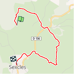
6,4 km | 7,8 km-effort
1h 55min
Oui
Randonnée Marche Saint-Geniez-ô-Merle - Les tours de Merle - Photo
Marche
houbart

Marche

Difficile
(2)
Saint-Geniez-ô-Merle, Nouvelle-Aquitaine, Corrèze, France
11,2 km | 16,9 km-effort
3h 42min
Oui
Randonnée Marche Camps-Saint-Mathurin-Léobazel - Le rocher du peintre - Photo
Marche
laurentbernardbrunel

Marche

Moyen
Camps-Saint-Mathurin-Léobazel, Nouvelle-Aquitaine, Corrèze, France
9,1 km | 11,2 km-effort
2h 2min
Non
Randonnée Marche La Chapelle-Saint-Géraud - la chappelle Saint Geraud - Photo
Marche
martinjacque

Marche

Moyen
(1)
La Chapelle-Saint-Géraud, Nouvelle-Aquitaine, Corrèze, France
5,7 km | 7,9 km-effort
1h 53min
Oui
Randonnée Marche Saint-Geniez-ô-Merle - les tours de Merle - Photo
Marche
Orage

Marche

Moyen
Saint-Geniez-ô-Merle, Nouvelle-Aquitaine, Corrèze, France
12 km | 17,9 km-effort
5h 12min
Oui
Randonnée Marche Saint-Geniez-ô-Merle - Les tours de Merle - Photo
Marche
Orage

Marche

Moyen
Saint-Geniez-ô-Merle, Nouvelle-Aquitaine, Corrèze, France
11,6 km | 17,7 km-effort
3h 40min
Oui
Randonnée Marche Sexcles - Le Carlat - Photo
Marche
merignac19

Marche

Sexcles, Nouvelle-Aquitaine, Corrèze, France
7,1 km | 10,7 km-effort
2h 9min
Oui
Randonnée Marche Hautefage - carosserie1juin24 - Photo
Marche
Karen Blakemore

Marche

Facile
Hautefage, Nouvelle-Aquitaine, Corrèze, France
3,3 km | 4,2 km-effort
1h 4min
Oui
Randonnée Trail Sexcles - treck Hautefage  - Photo
Trail
Chantafount05

Trail

Difficile
Sexcles, Nouvelle-Aquitaine, Corrèze, France
4,1 km | 7 km-effort
1h 21min
Non


Fermer
Mes abonnements