![](/images/other/stat-length.png)
![Randonnée Marche Rueil-Malmaison - Rueil nature - Photo](https://media.geolcdn.com/t/1900/400/ext.pjpeg?maxdim=2&url=https%3A%2F%2Fstatic1.geolcdn.com%2Fsiteimages%2Fupload%2Ffiles%2F1553511878bg_sport_marche.png)
Rueil nature
FRayssac
Utilisateur
![Longueur](/images/other/stat-length.png)
Longueur
10,3 km
![Altitude max](https://static1.geolcdn.com/siteimages/upload/files/1508320355ic_sort_altitude_max_24dp.png)
Altitude max
134 m
![Dénivelé positif](https://static1.geolcdn.com/siteimages/upload/files/1508320355ic_sort_den_pos_24dp.png)
Dénivelé positif
157 m
![Km-Effort](/images/other/stat-length.png)
Km-Effort
12,4 km
![Altitude min](https://static1.geolcdn.com/siteimages/upload/files/1508320355ic_sort_altitude_min_24dp.png)
Altitude min
16 m
![Dénivelé négatif](https://static1.geolcdn.com/siteimages/upload/files/1508320355ic_sort_den_neg_24dp.png)
Dénivelé négatif
158 m
![Boucle](https://static1.geolcdn.com/siteimages/upload/files/16400158638029165_repeat_loop_refresh_sync_direction_icon.png)
Boucle
Non
Date de création :
2014-12-10 00:00:00.0
Dernière modification :
2014-12-10 00:00:00.0
![Marche](https://static1.geolcdn.com/sitytour/trail-icons/101.png)
2h18
Difficulté : Moyen
![Scannez ce code QR pour ouvrir la randonnée dans l'application SityTrail](https://capi.geolives.com/qq0zvz2zws4bq2lad0pu/sitytour/trails/145577/qr.png?size=200)
Application GPS de randonnée GRATUITE
À propos
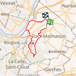
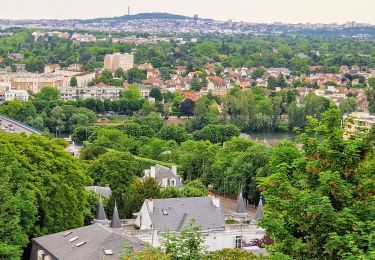
Randonnée Marche de 10,3 km à découvrir à Île-de-France, Hauts-de-Seine, Rueil-Malmaison. Cette randonnée est proposée par FRayssac.
Description
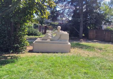
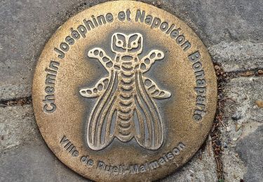
Boucle de Rueil centre ville depuis parc Bois Préau en passant par bois de Saint Cucufa et coulée verte vers les quais de Seine.
Localisation
Pays :
France
Région :
Île-de-France
Département/Province :
Hauts-de-Seine
Commune :
Rueil-Malmaison
Localité :
Unknown
Départ:(Dec)
Départ:(UTM)
439701 ; 5413892 (31U) N.
Commentaires
Randonnées à proximité
![Randonnée Marche Rueil-Malmaison - St Germain en Laye - Rueil Malmaison 28 km Inversee - Photo](https://media.geolcdn.com/t/375/260/b687f904-9338-4fa0-aef2-9bacff37d877.jpg&format=jpg&maxdim=2)
![Marche Marche](https://static1.geolcdn.com/sitytour/trail-icons/101.png)
St Germain en Laye - Rueil Malmaison 28 km Inversee
Marche
Facile
(1)
Rueil-Malmaison,
Île-de-France,
Hauts-de-Seine,
France
![](/images/other/stat-length.png)
28 km | 32 km-effort
6h 0min
![](https://static1.geolcdn.com/siteimages/upload/files/16400158638029165_repeat_loop_refresh_sync_direction_icon.png)
Non
![Randonnée Marche Bougival - Bougival-Saint-cucufa reel - Photo](https://media.geolcdn.com/t/375/260/f8214235-f5e3-4ba5-8084-044ba7cbf132.jpeg&format=jpg&maxdim=2)
![Marche Marche](https://static1.geolcdn.com/sitytour/trail-icons/101.png)
Bougival-Saint-cucufa reel
Marche
(1)
Bougival,
Île-de-France,
Yvelines,
France
![](/images/other/stat-length.png)
7,7 km | 10,3 km-effort
2h 29min
![](https://static1.geolcdn.com/siteimages/upload/files/16400158638029165_repeat_loop_refresh_sync_direction_icon.png)
Oui
![Randonnée Marche Boulogne-Billancourt - Parc de St Cloud et forêt de Fausses Reposes - Photo](https://media.geolcdn.com/t/375/260/ext.jpg?maxdim=2&url=https%3A%2F%2Fservices.sitytrail.com%2FGeolivesWS%2FDownloadMedia.ashx%3FTrailID%3D106613%26Media%3D11213_2.jpg)
![Marche Marche](https://static1.geolcdn.com/sitytour/trail-icons/101.png)
Parc de St Cloud et forêt de Fausses Reposes
Marche
Moyen
(1)
Boulogne-Billancourt,
Île-de-France,
Hauts-de-Seine,
France
![](/images/other/stat-length.png)
18,2 km | 23 km-effort
4h 30min
![](https://static1.geolcdn.com/siteimages/upload/files/16400158638029165_repeat_loop_refresh_sync_direction_icon.png)
Non
![Randonnée A pied Boulogne-Billancourt - Boulogne - Marne la Coquette - Ville d'Avray - Meudon - Photo](https://media.geolcdn.com/t/375/260/fed6b7bc-76e0-4d10-9619-38a76fb662e3.jpg&format=jpg&maxdim=2)
![A pied A pied](https://static1.geolcdn.com/sitytour/trail-icons/100.png)
Boulogne - Marne la Coquette - Ville d'Avray - Meudon
A pied
Difficile
Boulogne-Billancourt,
Île-de-France,
Hauts-de-Seine,
France
![](/images/other/stat-length.png)
29 km | 36 km-effort
8h 9min
![](https://static1.geolcdn.com/siteimages/upload/files/16400158638029165_repeat_loop_refresh_sync_direction_icon.png)
Non
![Randonnée A pied Rueil-Malmaison - La Seine impressioniste Etape 1 Rueil - Conflans Ste Honorine - Photo](https://media.geolcdn.com/t/375/260/c514a42a-e126-47ef-85f0-d75f60d63c7a.jpg&format=jpg&maxdim=2)
![A pied A pied](https://static1.geolcdn.com/sitytour/trail-icons/100.png)
La Seine impressioniste Etape 1 Rueil - Conflans Ste Honorine
A pied
Moyen
Rueil-Malmaison,
Île-de-France,
Hauts-de-Seine,
France
![](/images/other/stat-length.png)
32 km | 37 km-effort
8h 22min
![](https://static1.geolcdn.com/siteimages/upload/files/16400158638029165_repeat_loop_refresh_sync_direction_icon.png)
Non
![Randonnée Marche Rueil-Malmaison - De Rueil Malmaison aux Serres d'Auteuil via Suresnes - Photo](https://media.geolcdn.com/t/375/260/69c5aa69-7a4f-4e7d-be07-682d5ba1172b.jpg&format=jpg&maxdim=2)
![Marche Marche](https://static1.geolcdn.com/sitytour/trail-icons/101.png)
De Rueil Malmaison aux Serres d'Auteuil via Suresnes
Marche
Très facile
Rueil-Malmaison,
Île-de-France,
Hauts-de-Seine,
France
![](/images/other/stat-length.png)
22 km | 26 km-effort
5h 3min
![](https://static1.geolcdn.com/siteimages/upload/files/16400158638029165_repeat_loop_refresh_sync_direction_icon.png)
Non
![Randonnée Marche Rueil-Malmaison - Domaine Malmaison - Cité jardin Suresnes - Boulogne - Serres d'Auteuil - Photo](https://media.geolcdn.com/t/375/260/f35951a9-b213-4c85-9bfa-cc06ec3dd722.jpg&format=jpg&maxdim=2)
![Marche Marche](https://static1.geolcdn.com/sitytour/trail-icons/101.png)
Domaine Malmaison - Cité jardin Suresnes - Boulogne - Serres d'Auteuil
Marche
Facile
Rueil-Malmaison,
Île-de-France,
Hauts-de-Seine,
France
![](/images/other/stat-length.png)
22 km | 27 km-effort
4h 54min
![](https://static1.geolcdn.com/siteimages/upload/files/16400158638029165_repeat_loop_refresh_sync_direction_icon.png)
Non
![Randonnée Marche Rueil-Malmaison - De rueil Malmaison à St Germain en Laye - Photo](https://media.geolcdn.com/t/375/260/2cfb8298-4a88-4640-a039-54786d423968.jpg&format=jpg&maxdim=2)
![Marche Marche](https://static1.geolcdn.com/sitytour/trail-icons/101.png)
De rueil Malmaison à St Germain en Laye
Marche
Moyen
Rueil-Malmaison,
Île-de-France,
Hauts-de-Seine,
France
![](/images/other/stat-length.png)
28 km | 32 km-effort
5h 56min
![](https://static1.geolcdn.com/siteimages/upload/files/16400158638029165_repeat_loop_refresh_sync_direction_icon.png)
Non
![Randonnée Marche Rueil-Malmaison - Rueil Ville, château, Cucufa-Seine - Photo](https://media.geolcdn.com/t/375/260/c2b90b8f-08d6-4c14-833f-306078b35459.jpg&format=jpg&maxdim=2)
![Marche Marche](https://static1.geolcdn.com/sitytour/trail-icons/101.png)
Rueil Ville, château, Cucufa-Seine
Marche
Moyen
Rueil-Malmaison,
Île-de-France,
Hauts-de-Seine,
France
![](/images/other/stat-length.png)
9,6 km | 11,3 km-effort
2h 5min
![](https://static1.geolcdn.com/siteimages/upload/files/16400158638029165_repeat_loop_refresh_sync_direction_icon.png)
Oui