![](/images/other/stat-length.png)
![Randonnée V.T.T. Saint-Rémy-lès-Chevreuse - Vallée chevreuse : St remy les chevreuse-Boullay-Bullion-La celle les bordes Cernay la ville - Photo](https://media.geolcdn.com/t/1900/400/ext.pjpeg?maxdim=2&url=https%3A%2F%2Fstatic1.geolcdn.com%2Fsiteimages%2Fupload%2Ffiles%2F1524743154velo.jpg)
Vallée chevreuse : St remy les chevreuse-Boullay-Bullion-La celle les bordes Cernay la ville
guariso
Utilisateur
![Longueur](/images/other/stat-length.png)
Longueur
41 km
![Altitude max](https://static1.geolcdn.com/siteimages/upload/files/1508320355ic_sort_altitude_max_24dp.png)
Altitude max
182 m
![Dénivelé positif](https://static1.geolcdn.com/siteimages/upload/files/1508320355ic_sort_den_pos_24dp.png)
Dénivelé positif
494 m
![Km-Effort](/images/other/stat-length.png)
Km-Effort
48 km
![Altitude min](https://static1.geolcdn.com/siteimages/upload/files/1508320355ic_sort_altitude_min_24dp.png)
Altitude min
72 m
![Dénivelé négatif](https://static1.geolcdn.com/siteimages/upload/files/1508320355ic_sort_den_neg_24dp.png)
Dénivelé négatif
493 m
![Boucle](https://static1.geolcdn.com/siteimages/upload/files/16400158638029165_repeat_loop_refresh_sync_direction_icon.png)
Boucle
Oui
Date de création :
2014-12-10 00:00:00.0
Dernière modification :
2014-12-10 00:00:00.0
![V.T.T.](https://static1.geolcdn.com/sitytour/trail-icons/202.png)
2h52
Difficulté : Moyen
![Scannez ce code QR pour ouvrir la randonnée dans l'application SityTrail](https://capi.geolives.com/qq0zvz2zws4bq2lad0pu/sitytour/trails/144698/qr.png?size=200)
Application GPS de randonnée GRATUITE
À propos
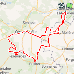
Randonnée V.T.T. de 41 km à découvrir à Île-de-France, Yvelines, Saint-Rémy-lès-Chevreuse. Cette randonnée est proposée par guariso.
Description
Rando VTT au départ de saint remy les chevreuse, se garer près du parking SNCF, départ sur sentier le long de l'ancienne voie ferrée, ca monte gentillement en sous bois. Le parcours alterne bitume et chemins en sous bois ou à travers champs.
Localisation
Pays :
France
Région :
Île-de-France
Département/Province :
Yvelines
Commune :
Saint-Rémy-lès-Chevreuse
Localité :
Unknown
Départ:(Dec)
Départ:(UTM)
431466 ; 5394952 (31U) N.
Commentaires
Randonnées à proximité
![Randonnée Marche Saint-Rémy-lès-Chevreuse - _Entre vallées et châteaux - Photo](https://media.geolcdn.com/t/375/260/ext.jpg?maxdim=2&url=https%3A%2F%2Fservices.sitytrail.com%2FGeolivesWS%2FDownloadMedia.ashx%3FTrailID%3D775643%26Media%3Dde7a4f97-3e1e-4613-9986-4282e306d83b.JPG)
![Marche Marche](https://static1.geolcdn.com/sitytour/trail-icons/101.png)
_Entre vallées et châteaux
Marche
Moyen
(13)
Saint-Rémy-lès-Chevreuse,
Île-de-France,
Yvelines,
France
![](/images/other/stat-length.png)
7,8 km | 9,6 km-effort
2h 0min
![](https://static1.geolcdn.com/siteimages/upload/files/16400158638029165_repeat_loop_refresh_sync_direction_icon.png)
Oui
![Randonnée Marche Chevreuse - _La balade de tous les plaisirs - Photo](https://media.geolcdn.com/t/375/260/ext.jpg?maxdim=2&url=https%3A%2F%2Fservices.sitytrail.com%2FGeolivesWS%2FDownloadMedia.ashx%3FTrailID%3D754966%26Media%3D761e5f27-0704-4761-a8b3-7fd3e291dd40.jpg)
![Marche Marche](https://static1.geolcdn.com/sitytour/trail-icons/101.png)
_La balade de tous les plaisirs
Marche
Facile
(8)
Chevreuse,
Île-de-France,
Yvelines,
France
![](/images/other/stat-length.png)
5,5 km | 7 km-effort
1h 30min
![](https://static1.geolcdn.com/siteimages/upload/files/16400158638029165_repeat_loop_refresh_sync_direction_icon.png)
Oui
![Randonnée Marche Chevreuse - _Sur les pas de Racine (première partie) - Photo](https://media.geolcdn.com/t/375/260/ext.jpg?maxdim=2&url=https%3A%2F%2Fservices.sitytrail.com%2FGeolivesWS%2FDownloadMedia.ashx%3FTrailID%3D745166%26Media%3Dd5380f95-aa62-43a2-a37c-8510f53d593d.JPG)
![Marche Marche](https://static1.geolcdn.com/sitytour/trail-icons/101.png)
_Sur les pas de Racine (première partie)
Marche
Facile
(7)
Chevreuse,
Île-de-France,
Yvelines,
France
![](/images/other/stat-length.png)
10,7 km | 14,5 km-effort
2h 30min
![](https://static1.geolcdn.com/siteimages/upload/files/16400158638029165_repeat_loop_refresh_sync_direction_icon.png)
Oui
![Randonnée Marche Choisel - _Si Choisel m'était conté - Photo](https://media.geolcdn.com/t/375/260/ext.jpg?maxdim=2&url=https%3A%2F%2Fservices.sitytrail.com%2FGeolivesWS%2FDownloadMedia.ashx%3FTrailID%3D172083%26Media%3De60082f0-edf4-45f4-997a-35e9c7c799de.jpg)
![Marche Marche](https://static1.geolcdn.com/sitytour/trail-icons/101.png)
_Si Choisel m'était conté
Marche
Facile
(8)
Choisel,
Île-de-France,
Yvelines,
France
![](/images/other/stat-length.png)
5,6 km | 6,6 km-effort
1h 27min
![](https://static1.geolcdn.com/siteimages/upload/files/16400158638029165_repeat_loop_refresh_sync_direction_icon.png)
Oui
![Randonnée Marche Gif-sur-Yvette - _Gif sur Yvette, une ville à la campagne - Photo](https://media.geolcdn.com/t/375/260/ext.jpg?maxdim=2&url=https%3A%2F%2Fservices.sitytrail.com%2FGeolivesWS%2FDownloadMedia.ashx%3FTrailID%3D779352%26Media%3D6efce478-230b-4926-9641-e6f0bf2b902d.jpg)
![Marche Marche](https://static1.geolcdn.com/sitytour/trail-icons/101.png)
_Gif sur Yvette, une ville à la campagne
Marche
Moyen
(3)
Gif-sur-Yvette,
Île-de-France,
Essonne,
France
![](/images/other/stat-length.png)
8,6 km | 10,5 km-effort
2h 0min
![](https://static1.geolcdn.com/siteimages/upload/files/16400158638029165_repeat_loop_refresh_sync_direction_icon.png)
Oui
![Randonnée Marche Magny-les-Hameaux - _La Vallée de la Mérantaise - Photo](https://media.geolcdn.com/t/375/260/ext.jpg?maxdim=2&url=https%3A%2F%2Fservices.sitytrail.com%2FGeolivesWS%2FDownloadMedia.ashx%3FTrailID%3D755616%26Media%3Deae23003-4ad7-4454-b083-3d96818374a8.jpg)
![Marche Marche](https://static1.geolcdn.com/sitytour/trail-icons/101.png)
_La Vallée de la Mérantaise
Marche
Facile
(5)
Magny-les-Hameaux,
Île-de-France,
Yvelines,
France
![](/images/other/stat-length.png)
9,7 km | 11,6 km-effort
2h 30min
![](https://static1.geolcdn.com/siteimages/upload/files/16400158638029165_repeat_loop_refresh_sync_direction_icon.png)
Oui
![Randonnée Marche Saint-Lambert - _Sur les pas de Racine (deuxième partie) - Photo](https://media.geolcdn.com/t/375/260/ext.jpg?maxdim=2&url=https%3A%2F%2Fservices.sitytrail.com%2FGeolivesWS%2FDownloadMedia.ashx%3FTrailID%3D745749%26Media%3Db1edb432-b6c8-43f7-9f4b-66b807e05156.jpg)
![Marche Marche](https://static1.geolcdn.com/sitytour/trail-icons/101.png)
_Sur les pas de Racine (deuxième partie)
Marche
Facile
(2)
Saint-Lambert,
Île-de-France,
Yvelines,
France
![](/images/other/stat-length.png)
10,5 km | 12,5 km-effort
2h 30min
![](https://static1.geolcdn.com/siteimages/upload/files/16400158638029165_repeat_loop_refresh_sync_direction_icon.png)
Oui
![Randonnée Marche Châteaufort - gitane à Chateaufort - Photo](https://media.geolcdn.com/t/375/260/ddb88f28-eed1-407a-8537-509b49789196.jpg&format=jpg&maxdim=2)
![Marche Marche](https://static1.geolcdn.com/sitytour/trail-icons/101.png)
gitane à Chateaufort
Marche
Facile
(1)
Châteaufort,
Île-de-France,
Yvelines,
France
![](/images/other/stat-length.png)
6,4 km | 7,7 km-effort
2h 3min
![](https://static1.geolcdn.com/siteimages/upload/files/16400158638029165_repeat_loop_refresh_sync_direction_icon.png)
Oui
![Randonnée Marche Milon-la-Chapelle - Yvelines_Milon-La-Chapelle=>Chemins_Beauregard&Jean-Racine=>Chevreuse - Photo](https://media.geolcdn.com/t/375/260/b9995b45-7638-4793-a22c-e5ba9a678abe.jpg&format=jpg&maxdim=2)
![Marche Marche](https://static1.geolcdn.com/sitytour/trail-icons/101.png)
Yvelines_Milon-La-Chapelle=>Chemins_Beauregard&Jean-Racine=>Chevreuse
Marche
Facile
(1)
Milon-la-Chapelle,
Île-de-France,
Yvelines,
France
![](/images/other/stat-length.png)
9,3 km | 12,7 km-effort
1h 56min
![](https://static1.geolcdn.com/siteimages/upload/files/16400158638029165_repeat_loop_refresh_sync_direction_icon.png)
Oui
impossible serveur de carte patch journée 93