![](/images/other/stat-length.png)
![Randonnée Marche Biriatou - Biriatou - Col d'Ibardin - Photo](https://media.geolcdn.com/t/1900/400/ext.pjpeg?maxdim=2&url=https%3A%2F%2Fstatic1.geolcdn.com%2Fsiteimages%2Fupload%2Ffiles%2F1553511878bg_sport_marche.png)
Biriatou - Col d'Ibardin
arbelie
Utilisateur
![Longueur](/images/other/stat-length.png)
Longueur
7,5 km
![Altitude max](https://static1.geolcdn.com/siteimages/upload/files/1508320355ic_sort_altitude_max_24dp.png)
Altitude max
530 m
![Dénivelé positif](https://static1.geolcdn.com/siteimages/upload/files/1508320355ic_sort_den_pos_24dp.png)
Dénivelé positif
461 m
![Km-Effort](/images/other/stat-length.png)
Km-Effort
12,9 km
![Altitude min](https://static1.geolcdn.com/siteimages/upload/files/1508320355ic_sort_altitude_min_24dp.png)
Altitude min
97 m
![Dénivelé négatif](https://static1.geolcdn.com/siteimages/upload/files/1508320355ic_sort_den_neg_24dp.png)
Dénivelé négatif
235 m
![Boucle](https://static1.geolcdn.com/siteimages/upload/files/16400158638029165_repeat_loop_refresh_sync_direction_icon.png)
Boucle
Non
Date de création :
2014-12-10 00:00:00.0
Dernière modification :
2014-12-10 00:00:00.0
![Marche](https://static1.geolcdn.com/sitytour/trail-icons/101.png)
--
Difficulté : Moyen
![Scannez ce code QR pour ouvrir la randonnée dans l'application SityTrail](https://capi.geolives.com/qq0zvz2zws4bq2lad0pu/sitytour/trails/142850/qr.png?size=200)
Application GPS de randonnée GRATUITE
À propos
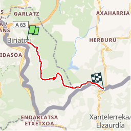
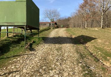
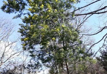
Randonnée Marche de 7,5 km à découvrir à Nouvelle-Aquitaine, Pyrénées-Atlantiques, Biriatou. Cette randonnée est proposée par arbelie.
Description
Petite randonnée sympathique le long de la frontière Espagnole.
Attention, ce n'est pas un boucle, prévoir le double du temps pour le retour...
Localisation
Pays :
France
Région :
Nouvelle-Aquitaine
Département/Province :
Pyrénées-Atlantiques
Commune :
Biriatou
Localité :
Unknown
Départ:(Dec)
Départ:(UTM)
602329 ; 4798514 (30T) N.
Commentaires
Randonnées à proximité
![Randonnée Marche Biriatou - Biriatou et lac Poiriers - Photo](https://media.geolcdn.com/t/375/260/ext.jpg?maxdim=2&url=https%3A%2F%2Fservices.sitytrail.com%2FGeolivesWS%2FDownloadMedia.ashx%3FTrailID%3D444455%26Media%3D20150712102756.jpg)
![Marche Marche](https://static1.geolcdn.com/sitytour/trail-icons/101.png)
Biriatou et lac Poiriers
Marche
Moyen
(1)
Biriatou,
Nouvelle-Aquitaine,
Pyrénées-Atlantiques,
France
![](/images/other/stat-length.png)
10,1 km | 17,1 km-effort
3h 45min
![](https://static1.geolcdn.com/siteimages/upload/files/16400158638029165_repeat_loop_refresh_sync_direction_icon.png)
Oui
![Randonnée Marche Irun - Ibarla - Cascade d'Aitzondo - Ermitage san Martzial 2024 01 21 - Photo](https://media.geolcdn.com/t/375/260/ext.jpg?maxdim=2&url=https%3A%2F%2Fservices.sitytrail.com%2FGeolivesWS%2FDownloadMedia.ashx%3FTrailID%3D530456%26Media%3Dfix__20160226111436.jpg)
![Marche Marche](https://static1.geolcdn.com/sitytour/trail-icons/101.png)
Ibarla - Cascade d'Aitzondo - Ermitage san Martzial 2024 01 21
Marche
Très difficile
Irun,
Pays basque autonome,
Guipuscoa,
Espagne
![](/images/other/stat-length.png)
12,1 km | 19,7 km-effort
4h 28min
![](https://static1.geolcdn.com/siteimages/upload/files/16400158638029165_repeat_loop_refresh_sync_direction_icon.png)
Oui
![Randonnée Marche Urrugne - Sentier des mulets - Photo](https://media.geolcdn.com/t/375/260/ext.jpg?maxdim=2&url=https%3A%2F%2Fmedia.geolcdn.com%2Ff%2F8bf6a509-6413-44f7-bef8-4f5e610a5577.jpg)
![Marche Marche](https://static1.geolcdn.com/sitytour/trail-icons/101.png)
Sentier des mulets
Marche
Moyen
Urrugne,
Nouvelle-Aquitaine,
Pyrénées-Atlantiques,
France
![](/images/other/stat-length.png)
9 km | 14 km-effort
2h 40min
![](https://static1.geolcdn.com/siteimages/upload/files/16400158638029165_repeat_loop_refresh_sync_direction_icon.png)
Oui
![Randonnée Marche Urrugne - ibardin- tour du lac - Photo](https://media.geolcdn.com/t/375/260/ext.jpg?maxdim=2&url=https%3A%2F%2Fmedia.geolcdn.com%2Ff%2F85f0b68d-ad13-42bf-bfcf-63c79487c473.jpg)
![Marche Marche](https://static1.geolcdn.com/sitytour/trail-icons/101.png)
ibardin- tour du lac
Marche
Moyen
(1)
Urrugne,
Nouvelle-Aquitaine,
Pyrénées-Atlantiques,
France
![](/images/other/stat-length.png)
10,5 km | 17,2 km-effort
4h 34min
![](https://static1.geolcdn.com/siteimages/upload/files/16400158638029165_repeat_loop_refresh_sync_direction_icon.png)
Oui
![Randonnée A pied Irun - SL-GI 1006 Cascada de Aitzondo - Photo](https://media.geolcdn.com/t/375/260/ext.jpg?maxdim=2&url=https%3A%2F%2Fmedia.geolcdn.com%2Ff%2F949c10e2-10b5-4598-a875-2bd7cf386c52.jpeg)
![A pied A pied](https://static1.geolcdn.com/sitytour/trail-icons/100.png)
SL-GI 1006 Cascada de Aitzondo
A pied
Facile
Irun,
Pays basque autonome,
Guipuscoa,
Espagne
![](/images/other/stat-length.png)
6 km | 8,4 km-effort
1h 54min
![](https://static1.geolcdn.com/siteimages/upload/files/16400158638029165_repeat_loop_refresh_sync_direction_icon.png)
Oui
![Randonnée Marche Urrugne - Ibardin Ziburumendi, Yasola forêt de Bera Gartzin - Photo](https://media.geolcdn.com/t/375/260/ext.jpg?maxdim=2&url=https%3A%2F%2Fmedia.geolcdn.com%2Ff%2F58a919a6-f152-4cb9-9f95-105c2a40ddd9.jpg)
![Marche Marche](https://static1.geolcdn.com/sitytour/trail-icons/101.png)
Ibardin Ziburumendi, Yasola forêt de Bera Gartzin
Marche
Moyen
Urrugne,
Nouvelle-Aquitaine,
Pyrénées-Atlantiques,
France
![](/images/other/stat-length.png)
12,1 km | 19,6 km-effort
4h 0min
![](https://static1.geolcdn.com/siteimages/upload/files/16400158638029165_repeat_loop_refresh_sync_direction_icon.png)
Oui
![Randonnée Marche Biriatou - biriatou chemin de la foret - Photo](https://media.geolcdn.com/t/375/260/ext.jpg?maxdim=2&url=https%3A%2F%2Fmedia.geolcdn.com%2Ff%2F88e58450-9581-446b-a93b-1872d9ed62c8.jpg)
![Marche Marche](https://static1.geolcdn.com/sitytour/trail-icons/101.png)
biriatou chemin de la foret
Marche
Facile
Biriatou,
Nouvelle-Aquitaine,
Pyrénées-Atlantiques,
France
![](/images/other/stat-length.png)
4 km | 6,4 km-effort
1h 21min
![](https://static1.geolcdn.com/siteimages/upload/files/16400158638029165_repeat_loop_refresh_sync_direction_icon.png)
Non
![Randonnée Marche Irun - Ibarla - Cascade d'Aitzondo - Ermitage san Martzial 2020 01 21 - Photo](https://media.geolcdn.com/t/375/260/ext.jpg?maxdim=2&url=https%3A%2F%2Fservices.sitytrail.com%2FGeolivesWS%2FDownloadMedia.ashx%3FTrailID%3D530456%26Media%3Dfix__20160226111436.jpg)
![Marche Marche](https://static1.geolcdn.com/sitytour/trail-icons/101.png)
Ibarla - Cascade d'Aitzondo - Ermitage san Martzial 2020 01 21
Marche
Irun,
Pays basque autonome,
Guipuscoa,
Espagne
![](/images/other/stat-length.png)
13 km | 21 km-effort
5h 4min
![](https://static1.geolcdn.com/siteimages/upload/files/16400158638029165_repeat_loop_refresh_sync_direction_icon.png)
Oui
![Randonnée Marche Hendaye - Hendaye Saint Sébastien GR121 Sentier du littoral - Photo](https://media.geolcdn.com/t/375/260/ext.jpg?maxdim=2&url=https%3A%2F%2Fmedia.geolcdn.com%2Ff%2Fcc4c2380-6e4a-4daa-be29-494539f023ee.jpg)
![Marche Marche](https://static1.geolcdn.com/sitytour/trail-icons/101.png)
Hendaye Saint Sébastien GR121 Sentier du littoral
Marche
Facile
Hendaye,
Nouvelle-Aquitaine,
Pyrénées-Atlantiques,
France
![](/images/other/stat-length.png)
54 km | 71 km-effort
5h 54min
![](https://static1.geolcdn.com/siteimages/upload/files/16400158638029165_repeat_loop_refresh_sync_direction_icon.png)
Oui