![](/images/other/stat-length.png)
![Randonnée Marche Thueyts - croix de Berland - Photo](https://media.geolcdn.com/t/1900/400/ext.pjpeg?maxdim=2&url=https%3A%2F%2Fservices.sitytrail.com%2FGeolivesWS%2FDownloadMedia.ashx%3FTrailID%3D141837%26Media%3D20120716110626.jpg)
croix de Berland
philoustetou
Utilisateur
![Longueur](/images/other/stat-length.png)
Longueur
10,8 km
![Altitude max](https://static1.geolcdn.com/siteimages/upload/files/1508320355ic_sort_altitude_max_24dp.png)
Altitude max
900 m
![Dénivelé positif](https://static1.geolcdn.com/siteimages/upload/files/1508320355ic_sort_den_pos_24dp.png)
Dénivelé positif
501 m
![Km-Effort](/images/other/stat-length.png)
Km-Effort
17,4 km
![Altitude min](https://static1.geolcdn.com/siteimages/upload/files/1508320355ic_sort_altitude_min_24dp.png)
Altitude min
470 m
![Dénivelé négatif](https://static1.geolcdn.com/siteimages/upload/files/1508320355ic_sort_den_neg_24dp.png)
Dénivelé négatif
501 m
![Boucle](https://static1.geolcdn.com/siteimages/upload/files/16400158638029165_repeat_loop_refresh_sync_direction_icon.png)
Boucle
Oui
Date de création :
2014-12-10 00:00:00.0
Dernière modification :
2014-12-10 00:00:00.0
![Marche](https://static1.geolcdn.com/sitytour/trail-icons/101.png)
2h58
Difficulté : Facile
![Scannez ce code QR pour ouvrir la randonnée dans l'application SityTrail](https://capi.geolives.com/qq0zvz2zws4bq2lad0pu/sitytour/trails/141837/qr.png?size=200)
Application GPS de randonnée GRATUITE
À propos
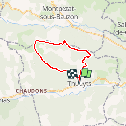
Randonnée Marche de 10,8 km à découvrir à Auvergne-Rhône-Alpes, Ardèche, Thueyts. Cette randonnée est proposée par philoustetou.
Description
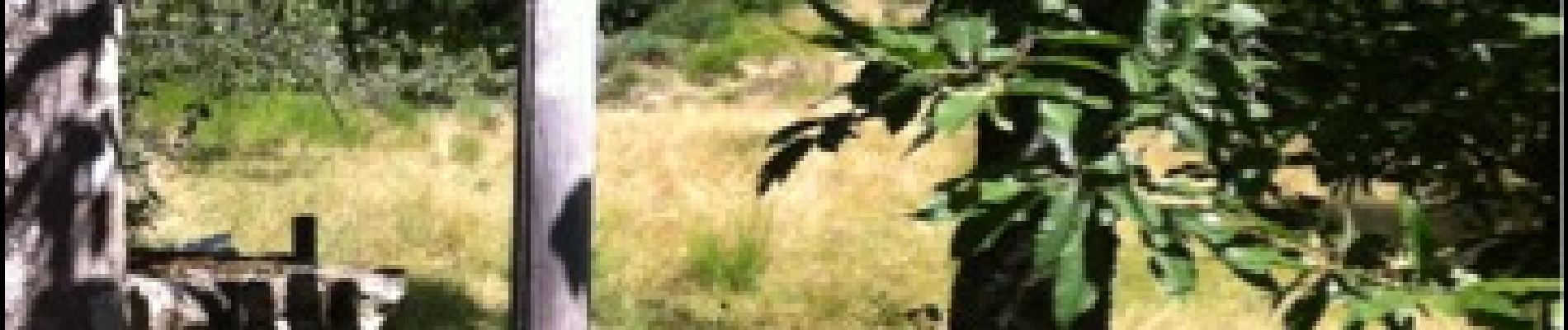
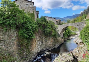
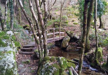
Rando de la croix de Berland en partant du centre de Thueyts, montée le long d'une coulée de lave puis on rejoint la crête vers Berland. La descente vers Thueyts sur un ancien chemin à travers une châtaigneraie. Très belle rando.
Localisation
Pays :
France
Région :
Auvergne-Rhône-Alpes
Département/Province :
Ardèche
Commune :
Thueyts
Localité :
Unknown
Départ:(Dec)
Départ:(UTM)
596802 ; 4947614 (31T) N.
Commentaires
Randonnées à proximité
![Randonnée Marche Jaujac - Jaujac Le Ventapet 14km - Photo](https://media.geolcdn.com/t/375/260/6a0eb2eb-cf2c-4f85-a155-e7f0aba82db8.jpg&format=jpg&maxdim=2)
![Marche Marche](https://static1.geolcdn.com/sitytour/trail-icons/101.png)
Jaujac Le Ventapet 14km
Marche
Très difficile
(1)
Jaujac,
Auvergne-Rhône-Alpes,
Ardèche,
France
![](/images/other/stat-length.png)
13,6 km | 23 km-effort
5h 18min
![](https://static1.geolcdn.com/siteimages/upload/files/16400158638029165_repeat_loop_refresh_sync_direction_icon.png)
Oui
![Randonnée Marche Saint-Pierre-de-Colombier - St Pierre le Colombier - Fontbonne - La Valette - Photo](https://media.geolcdn.com/t/375/260/ext.jpg?maxdim=2&url=https%3A%2F%2Fstatic1.geolcdn.com%2Fsiteimages%2Fupload%2Ffiles%2F1553511878bg_sport_marche.png)
![Marche Marche](https://static1.geolcdn.com/sitytour/trail-icons/101.png)
St Pierre le Colombier - Fontbonne - La Valette
Marche
Très difficile
(1)
Saint-Pierre-de-Colombier,
Auvergne-Rhône-Alpes,
Ardèche,
France
![](/images/other/stat-length.png)
11,5 km | 17,1 km-effort
4h 45min
![](https://static1.geolcdn.com/siteimages/upload/files/16400158638029165_repeat_loop_refresh_sync_direction_icon.png)
Oui
![Randonnée Marche Jaujac - Jaujac-Ventapet Serre-Rouge 14km. - Photo](https://media.geolcdn.com/t/375/260/10c01bbf-ca52-4fd7-bee6-e78e2ab077af.jpg&format=jpg&maxdim=2)
![Marche Marche](https://static1.geolcdn.com/sitytour/trail-icons/101.png)
Jaujac-Ventapet Serre-Rouge 14km.
Marche
Très difficile
Jaujac,
Auvergne-Rhône-Alpes,
Ardèche,
France
![](/images/other/stat-length.png)
14,2 km | 24 km-effort
5h 25min
![](https://static1.geolcdn.com/siteimages/upload/files/16400158638029165_repeat_loop_refresh_sync_direction_icon.png)
Oui
![Randonnée Marche Jaujac - 07 jaujac rocher de l aigle - Photo](https://media.geolcdn.com/t/375/260/1a765c03-1770-4ba1-9c9c-9314823e934b.jpg&format=jpg&maxdim=2)
![Marche Marche](https://static1.geolcdn.com/sitytour/trail-icons/101.png)
07 jaujac rocher de l aigle
Marche
Facile
(1)
Jaujac,
Auvergne-Rhône-Alpes,
Ardèche,
France
![](/images/other/stat-length.png)
11,2 km | 19,7 km-effort
6h 23min
![](https://static1.geolcdn.com/siteimages/upload/files/16400158638029165_repeat_loop_refresh_sync_direction_icon.png)
Oui
![Randonnée Marche Meyras - neyrac les bains - Photo](https://media.geolcdn.com/t/375/260/ext.jpg?maxdim=2&url=https%3A%2F%2Fstatic1.geolcdn.com%2Fsiteimages%2Fupload%2Ffiles%2F1553511878bg_sport_marche.png)
![Marche Marche](https://static1.geolcdn.com/sitytour/trail-icons/101.png)
neyrac les bains
Marche
Facile
(1)
Meyras,
Auvergne-Rhône-Alpes,
Ardèche,
France
![](/images/other/stat-length.png)
4,4 km | 6,8 km-effort
1h 36min
![](https://static1.geolcdn.com/siteimages/upload/files/16400158638029165_repeat_loop_refresh_sync_direction_icon.png)
Oui
![Randonnée Marche Chirols - Ste Marguerite - Photo](https://media.geolcdn.com/t/375/260/ext.jpg?maxdim=2&url=https%3A%2F%2Fstatic1.geolcdn.com%2Fsiteimages%2Fupload%2Ffiles%2F1553511878bg_sport_marche.png)
![Marche Marche](https://static1.geolcdn.com/sitytour/trail-icons/101.png)
Ste Marguerite
Marche
Moyen
(2)
Chirols,
Auvergne-Rhône-Alpes,
Ardèche,
France
![](/images/other/stat-length.png)
12,7 km | 22 km-effort
3h 57min
![](https://static1.geolcdn.com/siteimages/upload/files/16400158638029165_repeat_loop_refresh_sync_direction_icon.png)
Oui
![Randonnée Marche Jaujac - ARDECHE, JAUJAC. .PONT DE L ECHELLE O - Photo](https://media.geolcdn.com/t/375/260/306eb66a-9a51-42c8-b3b4-a2c469fe7bd7.jpg&format=jpg&maxdim=2)
![Marche Marche](https://static1.geolcdn.com/sitytour/trail-icons/101.png)
ARDECHE, JAUJAC. .PONT DE L ECHELLE O
Marche
Moyen
Jaujac,
Auvergne-Rhône-Alpes,
Ardèche,
France
![](/images/other/stat-length.png)
5,1 km | 8,3 km-effort
2h 33min
![](https://static1.geolcdn.com/siteimages/upload/files/16400158638029165_repeat_loop_refresh_sync_direction_icon.png)
Non
![Randonnée Marche Jaujac - 07_jaujac_Orgues_9km360m - Photo](https://media.geolcdn.com/t/375/260/944ad327-537f-4f2c-8001-5010f7cb1f7d.jpg&format=jpg&maxdim=2)
![Marche Marche](https://static1.geolcdn.com/sitytour/trail-icons/101.png)
07_jaujac_Orgues_9km360m
Marche
Moyen
Jaujac,
Auvergne-Rhône-Alpes,
Ardèche,
France
![](/images/other/stat-length.png)
9,1 km | 13,8 km-effort
3h 7min
![](https://static1.geolcdn.com/siteimages/upload/files/16400158638029165_repeat_loop_refresh_sync_direction_icon.png)
Oui
![Randonnée Marche Barnas - 231220 Barnas - Photo](https://media.geolcdn.com/t/375/260/a3dea727-4541-483e-aee3-864f9a0bf52c.jpg&format=jpg&maxdim=2)
![Marche Marche](https://static1.geolcdn.com/sitytour/trail-icons/101.png)
231220 Barnas
Marche
Moyen
Barnas,
Auvergne-Rhône-Alpes,
Ardèche,
France
![](/images/other/stat-length.png)
6,7 km | 9,9 km-effort
2h 15min
![](https://static1.geolcdn.com/siteimages/upload/files/16400158638029165_repeat_loop_refresh_sync_direction_icon.png)
Oui
tres belle rando