![](/images/other/stat-length.png)
![Randonnée Marche Thueyts - Chemin des plaideurs - Photo](https://media.geolcdn.com/t/1900/400/ext.pjpeg?maxdim=2&url=https%3A%2F%2Fservices.sitytrail.com%2FGeolivesWS%2FDownloadMedia.ashx%3FTrailID%3D141834%26Media%3D20120714121450.jpg)
Chemin des plaideurs
philoustetou
Utilisateur
![Longueur](/images/other/stat-length.png)
Longueur
10,3 km
![Altitude max](https://static1.geolcdn.com/siteimages/upload/files/1508320355ic_sort_altitude_max_24dp.png)
Altitude max
1030 m
![Dénivelé positif](https://static1.geolcdn.com/siteimages/upload/files/1508320355ic_sort_den_pos_24dp.png)
Dénivelé positif
640 m
![Km-Effort](/images/other/stat-length.png)
Km-Effort
18,9 km
![Altitude min](https://static1.geolcdn.com/siteimages/upload/files/1508320355ic_sort_altitude_min_24dp.png)
Altitude min
412 m
![Dénivelé négatif](https://static1.geolcdn.com/siteimages/upload/files/1508320355ic_sort_den_neg_24dp.png)
Dénivelé négatif
641 m
![Boucle](https://static1.geolcdn.com/siteimages/upload/files/16400158638029165_repeat_loop_refresh_sync_direction_icon.png)
Boucle
Oui
Date de création :
2014-12-10 00:00:00.0
Dernière modification :
2014-12-10 00:00:00.0
![Marche](https://static1.geolcdn.com/sitytour/trail-icons/101.png)
3h24
Difficulté : Moyen
![Scannez ce code QR pour ouvrir la randonnée dans l'application SityTrail](https://capi.geolives.com/qq0zvz2zws4bq2lad0pu/sitytour/trails/141834/qr.png?size=200)
Application GPS de randonnée GRATUITE
À propos
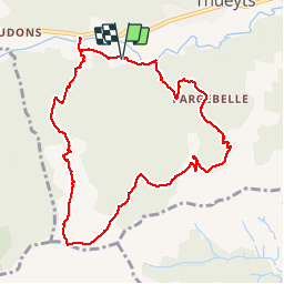
Randonnée Marche de 10,3 km à découvrir à Auvergne-Rhône-Alpes, Ardèche, Thueyts. Cette randonnée est proposée par philoustetou.
Description
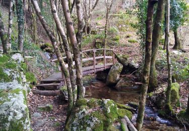
Ballade du "chemin des plaideurs" en partant du camping. Fort dénivellé montant et descendant sur sentiers et drailles, des framboises sur le chemin et température idéale pour marcher. Fin du circuit par la passerelle de Luzet au-dessus de l'Ardèche.
Localisation
Pays :
France
Région :
Auvergne-Rhône-Alpes
Département/Province :
Ardèche
Commune :
Thueyts
Localité :
Unknown
Départ:(Dec)
Départ:(UTM)
595572 ; 4946903 (31T) N.
Commentaires
Randonnées à proximité
![Randonnée Marche Jaujac - Jaujac Le Ventapet 14km - Photo](https://media.geolcdn.com/t/375/260/6a0eb2eb-cf2c-4f85-a155-e7f0aba82db8.jpg&format=jpg&maxdim=2)
![Marche Marche](https://static1.geolcdn.com/sitytour/trail-icons/101.png)
Jaujac Le Ventapet 14km
Marche
Très difficile
(1)
Jaujac,
Auvergne-Rhône-Alpes,
Ardèche,
France
![](/images/other/stat-length.png)
13,6 km | 23 km-effort
5h 18min
![](https://static1.geolcdn.com/siteimages/upload/files/16400158638029165_repeat_loop_refresh_sync_direction_icon.png)
Oui
![Randonnée Marche Saint-Pierre-de-Colombier - St Pierre le Colombier - Fontbonne - La Valette - Photo](https://media.geolcdn.com/t/375/260/ext.jpg?maxdim=2&url=https%3A%2F%2Fstatic1.geolcdn.com%2Fsiteimages%2Fupload%2Ffiles%2F1553511878bg_sport_marche.png)
![Marche Marche](https://static1.geolcdn.com/sitytour/trail-icons/101.png)
St Pierre le Colombier - Fontbonne - La Valette
Marche
Très difficile
(1)
Saint-Pierre-de-Colombier,
Auvergne-Rhône-Alpes,
Ardèche,
France
![](/images/other/stat-length.png)
11,5 km | 17,1 km-effort
4h 45min
![](https://static1.geolcdn.com/siteimages/upload/files/16400158638029165_repeat_loop_refresh_sync_direction_icon.png)
Oui
![Randonnée Marche Jaujac - 07 jaujac rocher de l aigle - Photo](https://media.geolcdn.com/t/375/260/1a765c03-1770-4ba1-9c9c-9314823e934b.jpg&format=jpg&maxdim=2)
![Marche Marche](https://static1.geolcdn.com/sitytour/trail-icons/101.png)
07 jaujac rocher de l aigle
Marche
Facile
(1)
Jaujac,
Auvergne-Rhône-Alpes,
Ardèche,
France
![](/images/other/stat-length.png)
11,2 km | 19,7 km-effort
6h 23min
![](https://static1.geolcdn.com/siteimages/upload/files/16400158638029165_repeat_loop_refresh_sync_direction_icon.png)
Oui
![Randonnée Marche Meyras - neyrac les bains - Photo](https://media.geolcdn.com/t/375/260/ext.jpg?maxdim=2&url=https%3A%2F%2Fstatic1.geolcdn.com%2Fsiteimages%2Fupload%2Ffiles%2F1553511878bg_sport_marche.png)
![Marche Marche](https://static1.geolcdn.com/sitytour/trail-icons/101.png)
neyrac les bains
Marche
Facile
(1)
Meyras,
Auvergne-Rhône-Alpes,
Ardèche,
France
![](/images/other/stat-length.png)
4,4 km | 6,8 km-effort
1h 36min
![](https://static1.geolcdn.com/siteimages/upload/files/16400158638029165_repeat_loop_refresh_sync_direction_icon.png)
Oui
![Randonnée Marche Jaujac - ARDECHE, JAUJAC. .PONT DE L ECHELLE O - Photo](https://media.geolcdn.com/t/375/260/306eb66a-9a51-42c8-b3b4-a2c469fe7bd7.jpg&format=jpg&maxdim=2)
![Marche Marche](https://static1.geolcdn.com/sitytour/trail-icons/101.png)
ARDECHE, JAUJAC. .PONT DE L ECHELLE O
Marche
Moyen
Jaujac,
Auvergne-Rhône-Alpes,
Ardèche,
France
![](/images/other/stat-length.png)
5,1 km | 8,3 km-effort
2h 33min
![](https://static1.geolcdn.com/siteimages/upload/files/16400158638029165_repeat_loop_refresh_sync_direction_icon.png)
Non
![Randonnée sport La Souche - De la Souche à Jaujac - Photo](https://media.geolcdn.com/t/375/260/3ee312a7-57c4-41b3-8f57-e35dcae92908.jpg&format=jpg&maxdim=2)
De la Souche à Jaujac
sport
Très facile
La Souche,
Auvergne-Rhône-Alpes,
Ardèche,
France
![](/images/other/stat-length.png)
13,3 km | 18 km-effort
Inconnu
![](https://static1.geolcdn.com/siteimages/upload/files/16400158638029165_repeat_loop_refresh_sync_direction_icon.png)
Non
![Randonnée Marche Jaujac - 07_jaujac_Orgues_9km360m - Photo](https://media.geolcdn.com/t/375/260/944ad327-537f-4f2c-8001-5010f7cb1f7d.jpg&format=jpg&maxdim=2)
![Marche Marche](https://static1.geolcdn.com/sitytour/trail-icons/101.png)
07_jaujac_Orgues_9km360m
Marche
Moyen
Jaujac,
Auvergne-Rhône-Alpes,
Ardèche,
France
![](/images/other/stat-length.png)
9,1 km | 13,8 km-effort
3h 7min
![](https://static1.geolcdn.com/siteimages/upload/files/16400158638029165_repeat_loop_refresh_sync_direction_icon.png)
Oui
![Randonnée Marche Barnas - 231220 Barnas - Photo](https://media.geolcdn.com/t/375/260/a3dea727-4541-483e-aee3-864f9a0bf52c.jpg&format=jpg&maxdim=2)
![Marche Marche](https://static1.geolcdn.com/sitytour/trail-icons/101.png)
231220 Barnas
Marche
Moyen
Barnas,
Auvergne-Rhône-Alpes,
Ardèche,
France
![](/images/other/stat-length.png)
6,7 km | 9,9 km-effort
2h 15min
![](https://static1.geolcdn.com/siteimages/upload/files/16400158638029165_repeat_loop_refresh_sync_direction_icon.png)
Oui
![Randonnée Marche Montpezat-sous-Bauzon - Balade Montpezat/Le Villaret - Les Grisières - Les Malfaugères - Photo](https://media.geolcdn.com/t/375/260/ext.jpg?maxdim=2&url=https%3A%2F%2Fstatic1.geolcdn.com%2Fsiteimages%2Fupload%2Ffiles%2F1553511878bg_sport_marche.png)
![Marche Marche](https://static1.geolcdn.com/sitytour/trail-icons/101.png)
Balade Montpezat/Le Villaret - Les Grisières - Les Malfaugères
Marche
Moyen
(1)
Montpezat-sous-Bauzon,
Auvergne-Rhône-Alpes,
Ardèche,
France
![](/images/other/stat-length.png)
6,9 km | 9,7 km-effort
2h 12min
![](https://static1.geolcdn.com/siteimages/upload/files/16400158638029165_repeat_loop_refresh_sync_direction_icon.png)
Oui