![](/images/other/stat-length.png)
![Randonnée Vélo Hoeilaert - Hoeilaart-La Hulpe-Foret de Soignes - Photo](https://media.geolcdn.com/t/1900/400/ext.pjpeg?maxdim=2&url=https%3A%2F%2Fstatic1.geolcdn.com%2Fsiteimages%2Fupload%2Ffiles%2F1524743154velo.jpg)
Hoeilaart-La Hulpe-Foret de Soignes
jcvroye
Utilisateur
![Longueur](/images/other/stat-length.png)
Longueur
21 km
![Altitude max](https://static1.geolcdn.com/siteimages/upload/files/1508320355ic_sort_altitude_max_24dp.png)
Altitude max
152 m
![Dénivelé positif](https://static1.geolcdn.com/siteimages/upload/files/1508320355ic_sort_den_pos_24dp.png)
Dénivelé positif
304 m
![Km-Effort](/images/other/stat-length.png)
Km-Effort
25 km
![Altitude min](https://static1.geolcdn.com/siteimages/upload/files/1508320355ic_sort_altitude_min_24dp.png)
Altitude min
63 m
![Dénivelé négatif](https://static1.geolcdn.com/siteimages/upload/files/1508320355ic_sort_den_neg_24dp.png)
Dénivelé négatif
304 m
![Boucle](https://static1.geolcdn.com/siteimages/upload/files/16400158638029165_repeat_loop_refresh_sync_direction_icon.png)
Boucle
Oui
Date de création :
2014-12-10 00:00:00.0
Dernière modification :
2014-12-10 00:00:00.0
![Vélo](https://static1.geolcdn.com/sitytour/trail-icons/200.png)
1h23
Difficulté : Facile
![Scannez ce code QR pour ouvrir la randonnée dans l'application SityTrail](https://capi.geolives.com/qq0zvz2zws4bq2lad0pu/sitytour/trails/136789/qr.png?size=200)
Application GPS de randonnée GRATUITE
À propos
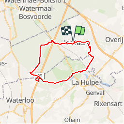
Randonnée Vélo de 21 km à découvrir à Flandre, Brabant flamand, Hoeilaert. Cette randonnée est proposée par jcvroye.
Description
Balade au départ de la place de Hoeilaart ( Parking aisé ) et passage par le château de La Hulpe, Forêt de Soignes, Groenendael ( Passerelle du chemin de fer ) et retour
Localisation
Pays :
Belgique
Région :
Flandre
Département/Province :
Brabant flamand
Commune :
Hoeilaert
Localité :
Hoeilaart
Départ:(Dec)
Départ:(UTM)
603844 ; 5625080 (31U) N.
Commentaires
Randonnées à proximité
![Randonnée Marche Hoeilaert - RL-GG-04_Hoielart_Genval - Photo](https://media.geolcdn.com/t/375/260/364592d0-bbf8-45ce-9ea9-708b8ca7581f.jpg&format=jpg&maxdim=2)
![Marche Marche](https://static1.geolcdn.com/sitytour/trail-icons/101.png)
RL-GG-04_Hoielart_Genval
Marche
Très difficile
(6)
Hoeilaert,
Flandre,
Brabant flamand,
Belgique
![](/images/other/stat-length.png)
23 km | 28 km-effort
5h 54min
![](https://static1.geolcdn.com/siteimages/upload/files/16400158638029165_repeat_loop_refresh_sync_direction_icon.png)
Non
![Randonnée Marche Auderghem - RB-Br-09 Rac02 - Photo](https://media.geolcdn.com/t/375/260/ext.jpg?maxdim=2&url=https%3A%2F%2Fservices.sitytrail.com%2FGeolivesWS%2FDownloadMedia.ashx%3FTrailID%3D247903%26Media%3D4f2f6ef8-5647-4df5-b72e-d8a55c5e5b6f.jpg)
![Marche Marche](https://static1.geolcdn.com/sitytour/trail-icons/101.png)
RB-Br-09 Rac02
Marche
Facile
(9)
Auderghem,
Bruxelles-Capitale,
Inconnu,
Belgique
![](/images/other/stat-length.png)
15,3 km | 18 km-effort
4h 5min
![](https://static1.geolcdn.com/siteimages/upload/files/16400158638029165_repeat_loop_refresh_sync_direction_icon.png)
Oui
![Randonnée Marche Auderghem - RB-Br-09 - Photo](https://media.geolcdn.com/t/375/260/ext.jpg?maxdim=2&url=https%3A%2F%2Fservices.sitytrail.com%2FGeolivesWS%2FDownloadMedia.ashx%3FTrailID%3D247899%26Media%3D7b6d3a4f-3999-4d35-8f7d-f23163489b77.jpg)
![Marche Marche](https://static1.geolcdn.com/sitytour/trail-icons/101.png)
RB-Br-09
Marche
Moyen
(8)
Auderghem,
Bruxelles-Capitale,
Inconnu,
Belgique
![](/images/other/stat-length.png)
20 km | 25 km-effort
5h 34min
![](https://static1.geolcdn.com/siteimages/upload/files/16400158638029165_repeat_loop_refresh_sync_direction_icon.png)
Oui
![Randonnée Marche La Hulpe - RB-Bw-12_La-Hulpe_via-racc-1-et-2 - Photo](https://media.geolcdn.com/t/375/260/ext.jpg?maxdim=2&url=https%3A%2F%2Fservices.sitytrail.com%2FGeolivesWS%2FDownloadMedia.ashx%3FTrailID%3D220408%26Media%3D24b0bc9e-ebac-4d93-8d00-eff7571ad0a0.jpg)
![Marche Marche](https://static1.geolcdn.com/sitytour/trail-icons/101.png)
RB-Bw-12_La-Hulpe_via-racc-1-et-2
Marche
Difficile
(15)
La Hulpe,
Wallonie,
Brabant wallon,
Belgique
![](/images/other/stat-length.png)
14,3 km | 17,7 km-effort
4h 1min
![](https://static1.geolcdn.com/siteimages/upload/files/16400158638029165_repeat_loop_refresh_sync_direction_icon.png)
Oui
![Randonnée V.T.T. Rhode-Saint-Genèse - VTT des etangs - Photo](https://media.geolcdn.com/t/375/260/ext.jpg?maxdim=2&url=https%3A%2F%2Fservices.sitytrail.com%2FGeolivesWS%2FDownloadMedia.ashx%3FTrailID%3D672124%26Media%3Df9c91142-2f99-4e68-a9bd-48ecc49645c7.JPG)
![V.T.T. V.T.T.](https://static1.geolcdn.com/sitytour/trail-icons/202.png)
VTT des etangs
V.T.T.
Moyen
(1)
Rhode-Saint-Genèse,
Flandre,
Brabant flamand,
Belgique
![](/images/other/stat-length.png)
31 km | 37 km-effort
2h 24min
![](https://static1.geolcdn.com/siteimages/upload/files/16400158638029165_repeat_loop_refresh_sync_direction_icon.png)
Non
![Randonnée Marche La Hulpe - La Hulpe - Circuit Natura 2000, des sites qui valent le détour - Bw02 - Photo](https://media.geolcdn.com/t/375/260/7fa79586-43de-4fc0-89c7-4bc45138438a.jpg&format=jpg&maxdim=2)
![Marche Marche](https://static1.geolcdn.com/sitytour/trail-icons/101.png)
La Hulpe - Circuit Natura 2000, des sites qui valent le détour - Bw02
Marche
Moyen
(5)
La Hulpe,
Wallonie,
Brabant wallon,
Belgique
![](/images/other/stat-length.png)
4,7 km | 5,9 km-effort
1h 16min
![](https://static1.geolcdn.com/siteimages/upload/files/16400158638029165_repeat_loop_refresh_sync_direction_icon.png)
Non
![Randonnée V.T.T. Rhode-Saint-Genèse - vtt de la forêt de Soigne - Photo](https://media.geolcdn.com/t/375/260/ext.jpg?maxdim=2&url=https%3A%2F%2Fservices.sitytrail.com%2FGeolivesWS%2FDownloadMedia.ashx%3FTrailID%3D394333%26Media%3Daba8d68d-2f84-442f-b081-8683a39ccf4b.JPG)
![V.T.T. V.T.T.](https://static1.geolcdn.com/sitytour/trail-icons/202.png)
vtt de la forêt de Soigne
V.T.T.
Facile
(1)
Rhode-Saint-Genèse,
Flandre,
Brabant flamand,
Belgique
![](/images/other/stat-length.png)
31 km | 38 km-effort
2h 27min
![](https://static1.geolcdn.com/siteimages/upload/files/16400158638029165_repeat_loop_refresh_sync_direction_icon.png)
Oui
![Randonnée Marche Rhode-Saint-Genèse - De Rhode Saint-Genèse à Groenendaal parl la forêt de Soignes - Photo](https://media.geolcdn.com/t/375/260/ext.jpg?maxdim=2&url=https%3A%2F%2Fservices.sitytrail.com%2FGeolivesWS%2FDownloadMedia.ashx%3FTrailID%3D361516%26Media%3Dafc15552-96c3-47a7-a25a-a7fd8498bfed.JPG)
![Marche Marche](https://static1.geolcdn.com/sitytour/trail-icons/101.png)
De Rhode Saint-Genèse à Groenendaal parl la forêt de Soignes
Marche
Facile
(4)
Rhode-Saint-Genèse,
Flandre,
Brabant flamand,
Belgique
![](/images/other/stat-length.png)
10,3 km | 11,9 km-effort
2h 36min
![](https://static1.geolcdn.com/siteimages/upload/files/16400158638029165_repeat_loop_refresh_sync_direction_icon.png)
Oui
![Randonnée Marche Auderghem - RB-Br-09 Rac01 - Photo](https://media.geolcdn.com/t/375/260/ext.jpg?maxdim=2&url=https%3A%2F%2Fservices.sitytrail.com%2FGeolivesWS%2FDownloadMedia.ashx%3FTrailID%3D247901%26Media%3D4f2f6ef8-5647-4df5-b72e-d8a55c5e5b6f.jpg)
![Marche Marche](https://static1.geolcdn.com/sitytour/trail-icons/101.png)
RB-Br-09 Rac01
Marche
Facile
(4)
Auderghem,
Bruxelles-Capitale,
Inconnu,
Belgique
![](/images/other/stat-length.png)
16 km | 19,1 km-effort
4h 20min
![](https://static1.geolcdn.com/siteimages/upload/files/16400158638029165_repeat_loop_refresh_sync_direction_icon.png)
Oui
belle variété entre village château et foret
assenois