![](/images/other/stat-length.png)
![Randonnée Marche Thann - OEIL DE LA SORCIERE - Photo](https://media.geolcdn.com/t/1900/400/ext.pjpeg?maxdim=2&url=https%3A%2F%2Fstatic1.geolcdn.com%2Fsiteimages%2Fupload%2Ffiles%2F1553511878bg_sport_marche.png)
OEIL DE LA SORCIERE
patrickbeyrath
Utilisateur
![Longueur](/images/other/stat-length.png)
Longueur
8,1 km
![Altitude max](https://static1.geolcdn.com/siteimages/upload/files/1508320355ic_sort_altitude_max_24dp.png)
Altitude max
657 m
![Dénivelé positif](https://static1.geolcdn.com/siteimages/upload/files/1508320355ic_sort_den_pos_24dp.png)
Dénivelé positif
343 m
![Km-Effort](/images/other/stat-length.png)
Km-Effort
12,7 km
![Altitude min](https://static1.geolcdn.com/siteimages/upload/files/1508320355ic_sort_altitude_min_24dp.png)
Altitude min
367 m
![Dénivelé négatif](https://static1.geolcdn.com/siteimages/upload/files/1508320355ic_sort_den_neg_24dp.png)
Dénivelé négatif
345 m
![Boucle](https://static1.geolcdn.com/siteimages/upload/files/16400158638029165_repeat_loop_refresh_sync_direction_icon.png)
Boucle
Oui
Date de création :
2018-10-13 05:53:47.417
Dernière modification :
2018-10-13 05:53:47.429
![Marche](https://static1.geolcdn.com/sitytour/trail-icons/101.png)
--
Difficulté : Moyen
![Scannez ce code QR pour ouvrir la randonnée dans l'application SityTrail](https://capi.geolives.com/qq0zvz2zws4bq2lad0pu/sitytour/trails/134626/qr.png?size=200)
Application GPS de randonnée GRATUITE
À propos
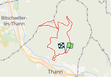
Randonnée Marche de 8,1 km à découvrir à Grand Est, Haut-Rhin, Thann. Cette randonnée est proposée par patrickbeyrath.
Description
Maison Forestière-rect.ROUGE direction oeil de la Sorcière-Haut du Grumbach-Col de Grumbach-Rect.Rouge blanc rouge-Belvédère Roche Albert-Grumbachkopf-Col de Grumbach et retour par Versteinerterwald-Kaltenbach
Localisation
Pays :
France
Région :
Grand Est
Département/Province :
Haut-Rhin
Commune :
Thann
Localité :
Unknown
Départ:(Dec)
Départ:(UTM)
358369 ; 5297732 (32T) N.
Commentaires
Randonnées à proximité
![Randonnée Marche Soultz-Haut-Rhin - Hartmannswillerkopf - Circuit découverte - Photo](https://media.geolcdn.com/t/375/260/ext.jpg?maxdim=2&url=https%3A%2F%2Fservices.sitytrail.com%2FGeolivesWS%2FDownloadMedia.ashx%3FTrailID%3D422294%26Media%3Dfix__20150517124954.jpg)
![Marche Marche](https://static1.geolcdn.com/sitytour/trail-icons/101.png)
Hartmannswillerkopf - Circuit découverte
Marche
Facile
(1)
Soultz-Haut-Rhin,
Grand Est,
Haut-Rhin,
France
![](/images/other/stat-length.png)
3,6 km | 5,2 km-effort
1h 46min
![](https://static1.geolcdn.com/siteimages/upload/files/16400158638029165_repeat_loop_refresh_sync_direction_icon.png)
Oui
![Randonnée Marche Soultz-Haut-Rhin - Hartmannswillerkopf - Circuit anneau bleu - Photo](https://media.geolcdn.com/t/375/260/ext.jpg?maxdim=2&url=https%3A%2F%2Fservices.sitytrail.com%2FGeolivesWS%2FDownloadMedia.ashx%3FTrailID%3D422291%26Media%3Dfix__20150517150228.jpg)
![Marche Marche](https://static1.geolcdn.com/sitytour/trail-icons/101.png)
Hartmannswillerkopf - Circuit anneau bleu
Marche
Moyen
(1)
Soultz-Haut-Rhin,
Grand Est,
Haut-Rhin,
France
![](/images/other/stat-length.png)
3,7 km | 5,9 km-effort
1h 37min
![](https://static1.geolcdn.com/siteimages/upload/files/16400158638029165_repeat_loop_refresh_sync_direction_icon.png)
Oui
![Randonnée Autre activité Steinbach - lac du ballon - Photo](https://media.geolcdn.com/t/375/260/ext.jpg?maxdim=2&url=https%3A%2F%2Fservices.sitytrail.com%2FGeolivesWS%2FDownloadMedia.ashx%3FTrailID%3D210434%26Media%3Dfix__20130805111422.jpg)
![Autre activité Autre activité](https://static1.geolcdn.com/sitytour/trail-icons/900.png)
lac du ballon
Autre activité
Très facile
(1)
Steinbach,
Grand Est,
Haut-Rhin,
France
![](/images/other/stat-length.png)
33 km | 64 km-effort
5h 1min
![](https://static1.geolcdn.com/siteimages/upload/files/16400158638029165_repeat_loop_refresh_sync_direction_icon.png)
Non
![Randonnée Marche Steinbach - Cascade de Erzenbach - Photo](https://media.geolcdn.com/t/375/260/069cb34c-c699-4fdf-8c9c-4524251a300c.jpg&format=jpg&maxdim=2)
![Marche Marche](https://static1.geolcdn.com/sitytour/trail-icons/101.png)
Cascade de Erzenbach
Marche
Moyen
Steinbach,
Grand Est,
Haut-Rhin,
France
![](/images/other/stat-length.png)
6 km | 8,8 km-effort
1h 32min
![](https://static1.geolcdn.com/siteimages/upload/files/16400158638029165_repeat_loop_refresh_sync_direction_icon.png)
Oui
![Randonnée Marche Bourbach-le-Haut - Tour du Rossberg - Gsang - Thannerhubel - Photo](https://media.geolcdn.com/t/375/260/d4089ace-97e6-4d95-86a3-a999ece263d3.jpg&format=jpg&maxdim=2)
![Marche Marche](https://static1.geolcdn.com/sitytour/trail-icons/101.png)
Tour du Rossberg - Gsang - Thannerhubel
Marche
Difficile
Bourbach-le-Haut,
Grand Est,
Haut-Rhin,
France
![](/images/other/stat-length.png)
11,4 km | 18,5 km-effort
4h 12min
![](https://static1.geolcdn.com/siteimages/upload/files/16400158638029165_repeat_loop_refresh_sync_direction_icon.png)
Oui
![Randonnée Vélo de route Cernay - Le Grand ballon de Cernay - Photo](https://media.geolcdn.com/t/375/260/8eb85347-6368-4eeb-8b65-86ddce4529dc.jpg&format=jpg&maxdim=2)
![Vélo de route Vélo de route](https://static1.geolcdn.com/sitytour/trail-icons/201.png)
Le Grand ballon de Cernay
Vélo de route
Difficile
Cernay,
Grand Est,
Haut-Rhin,
France
![](/images/other/stat-length.png)
23 km | 36 km-effort
2h 15min
![](https://static1.geolcdn.com/siteimages/upload/files/16400158638029165_repeat_loop_refresh_sync_direction_icon.png)
Non
![Randonnée Trail Wattwiller - The History Ultra - Stage 1 - Photo](https://media.geolcdn.com/t/375/260/ext.jpg?maxdim=2&url=https%3A%2F%2Fstatic1.geolcdn.com%2Fsiteimages%2Fupload%2Ffiles%2F1524743154running.jpg)
![Trail Trail](https://static1.geolcdn.com/sitytour/trail-icons/104.png)
The History Ultra - Stage 1
Trail
Très facile
(1)
Wattwiller,
Grand Est,
Haut-Rhin,
France
![](/images/other/stat-length.png)
28 km | 48 km-effort
Inconnu
![](https://static1.geolcdn.com/siteimages/upload/files/16400158638029165_repeat_loop_refresh_sync_direction_icon.png)
Non
![Randonnée Marche Thann - JD 14/20 Thann-roche--albert--grumbachkopf - Photo](https://media.geolcdn.com/t/375/260/ext.jpg?maxdim=2&url=https%3A%2F%2Fstatic1.geolcdn.com%2Fsiteimages%2Fupload%2Ffiles%2F1553511878bg_sport_marche.png)
![Marche Marche](https://static1.geolcdn.com/sitytour/trail-icons/101.png)
JD 14/20 Thann-roche--albert--grumbachkopf
Marche
Moyen
(1)
Thann,
Grand Est,
Haut-Rhin,
France
![](/images/other/stat-length.png)
7,6 km | 12 km-effort
2h 28min
![](https://static1.geolcdn.com/siteimages/upload/files/16400158638029165_repeat_loop_refresh_sync_direction_icon.png)
Oui
![Randonnée A pied Bitschwiller-lès-Thann - Bitschwiller les Thann - Rehbrunnel - Abri du Becherkopf - Roche Albert - Photo](https://media.geolcdn.com/t/375/260/ext.jpg?maxdim=2&url=https%3A%2F%2Fstatic1.geolcdn.com%2Fsiteimages%2Fupload%2Ffiles%2F1545311037marcheuse_200dpi.jpg)
![A pied A pied](https://static1.geolcdn.com/sitytour/trail-icons/100.png)
Bitschwiller les Thann - Rehbrunnel - Abri du Becherkopf - Roche Albert
A pied
Moyen
(1)
Bitschwiller-lès-Thann,
Grand Est,
Haut-Rhin,
France
![](/images/other/stat-length.png)
10,3 km | 16,4 km-effort
Inconnu
![](https://static1.geolcdn.com/siteimages/upload/files/16400158638029165_repeat_loop_refresh_sync_direction_icon.png)
Oui