![](/images/other/stat-length.png)
![Randonnée V.T.T. Chaumont - Corgebin Ferme_La_Borde Neuilly s/ Suize - Photo](https://media.geolcdn.com/t/1900/400/ext.pjpeg?maxdim=2&url=https%3A%2F%2Fstatic1.geolcdn.com%2Fsiteimages%2Fupload%2Ffiles%2F1524743154velo.jpg)
Corgebin Ferme_La_Borde Neuilly s/ Suize
piloiseau
Utilisateur
![Longueur](/images/other/stat-length.png)
Longueur
18 km
![Altitude max](https://static1.geolcdn.com/siteimages/upload/files/1508320355ic_sort_altitude_max_24dp.png)
Altitude max
369 m
![Dénivelé positif](https://static1.geolcdn.com/siteimages/upload/files/1508320355ic_sort_den_pos_24dp.png)
Dénivelé positif
246 m
![Km-Effort](/images/other/stat-length.png)
Km-Effort
21 km
![Altitude min](https://static1.geolcdn.com/siteimages/upload/files/1508320355ic_sort_altitude_min_24dp.png)
Altitude min
282 m
![Dénivelé négatif](https://static1.geolcdn.com/siteimages/upload/files/1508320355ic_sort_den_neg_24dp.png)
Dénivelé négatif
213 m
![Boucle](https://static1.geolcdn.com/siteimages/upload/files/16400158638029165_repeat_loop_refresh_sync_direction_icon.png)
Boucle
Non
Date de création :
2014-12-10 00:00:00.0
Dernière modification :
2014-12-10 00:00:00.0
![V.T.T.](https://static1.geolcdn.com/sitytour/trail-icons/202.png)
--
Difficulté : Très facile
![Scannez ce code QR pour ouvrir la randonnée dans l'application SityTrail](https://capi.geolives.com/qq0zvz2zws4bq2lad0pu/sitytour/trails/134549/qr.png?size=200)
Application GPS de randonnée GRATUITE
À propos
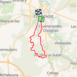
Randonnée V.T.T. de 18 km à découvrir à Grand Est, Haute-Marne, Chaumont. Cette randonnée est proposée par piloiseau.
Description
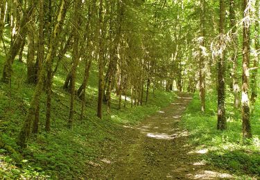
Facile dans la forêt du Corgebin. Après la ferme La_Borde, on entre dans la forêt en contournant un champ qui s'interpose et donc en revenant sur ses pas sur 200m.
Localisation
Pays :
France
Région :
Grand Est
Département/Province :
Haute-Marne
Commune :
Chaumont
Localité :
Unknown
Départ:(Dec)
Départ:(UTM)
658193 ; 5329150 (31U) N.
Commentaires
Randonnées à proximité
![Randonnée Marche Chaumont - Boucle 31 km autour de Chaumont - Photo](https://media.geolcdn.com/t/375/260/cbc46c4d-5909-46e1-804f-dfb6d68e47a3.jpg&format=jpg&maxdim=2)
![Marche Marche](https://static1.geolcdn.com/sitytour/trail-icons/101.png)
Boucle 31 km autour de Chaumont
Marche
Très difficile
Chaumont,
Grand Est,
Haute-Marne,
France
![](/images/other/stat-length.png)
31 km | 36 km-effort
6h 35min
![](https://static1.geolcdn.com/siteimages/upload/files/16400158638029165_repeat_loop_refresh_sync_direction_icon.png)
Oui
![Randonnée Marche Chaumont - la vendue-chaumont01 - Photo](https://media.geolcdn.com/t/375/260/ext.jpg?maxdim=2&url=https%3A%2F%2Fstatic1.geolcdn.com%2Fsiteimages%2Fupload%2Ffiles%2F1553511878bg_sport_marche.png)
![Marche Marche](https://static1.geolcdn.com/sitytour/trail-icons/101.png)
la vendue-chaumont01
Marche
Facile
(1)
Chaumont,
Grand Est,
Haute-Marne,
France
![](/images/other/stat-length.png)
8,7 km | 10,2 km-effort
1h 55min
![](https://static1.geolcdn.com/siteimages/upload/files/16400158638029165_repeat_loop_refresh_sync_direction_icon.png)
Oui
![Randonnée V.T.T. Chaumont - Corgebin Ferme_La_Borde Neuilly s/ Suize - Photo](https://media.geolcdn.com/t/375/260/ext.jpg?maxdim=2&url=https%3A%2F%2Fstatic1.geolcdn.com%2Fsiteimages%2Fupload%2Ffiles%2F1524743154velo.jpg)
![V.T.T. V.T.T.](https://static1.geolcdn.com/sitytour/trail-icons/202.png)
Corgebin Ferme_La_Borde Neuilly s/ Suize
V.T.T.
Très facile
(1)
Chaumont,
Grand Est,
Haute-Marne,
France
![](/images/other/stat-length.png)
20 km | 24 km-effort
Inconnu
![](https://static1.geolcdn.com/siteimages/upload/files/16400158638029165_repeat_loop_refresh_sync_direction_icon.png)
Oui
![Randonnée Marche Chaumont - Le Corgebin 8,5km - Photo](https://media.geolcdn.com/t/375/260/ext.jpg?maxdim=2&url=https%3A%2F%2Fstatic1.geolcdn.com%2Fsiteimages%2Fupload%2Ffiles%2F1553511878bg_sport_marche.png)
![Marche Marche](https://static1.geolcdn.com/sitytour/trail-icons/101.png)
Le Corgebin 8,5km
Marche
Moyen
(1)
Chaumont,
Grand Est,
Haute-Marne,
France
![](/images/other/stat-length.png)
8,3 km | 9,9 km-effort
2h 15min
![](https://static1.geolcdn.com/siteimages/upload/files/16400158638029165_repeat_loop_refresh_sync_direction_icon.png)
Oui
![Randonnée Marche nordique Chaumont - marche nordique AJPC philippe - Photo](https://media.geolcdn.com/t/375/260/ext.jpg?maxdim=2&url=https%3A%2F%2Fstatic1.geolcdn.com%2Fsiteimages%2Fupload%2Ffiles%2F1545311037marcheuse_200dpi.jpg)
![Marche nordique Marche nordique](https://static1.geolcdn.com/sitytour/trail-icons/102.png)
marche nordique AJPC philippe
Marche nordique
Moyen
(1)
Chaumont,
Grand Est,
Haute-Marne,
France
![](/images/other/stat-length.png)
9,3 km | 10,9 km-effort
1h 58min
![](https://static1.geolcdn.com/siteimages/upload/files/16400158638029165_repeat_loop_refresh_sync_direction_icon.png)
Oui
![Randonnée Marche Chaumont - Chaumont centre-Verbiesles-Ville aux bois-Chaumont - Photo](https://media.geolcdn.com/t/375/260/e2fab6d3-c0c5-465c-b883-2870626abdcf.jpg&format=jpg&maxdim=2)
![Marche Marche](https://static1.geolcdn.com/sitytour/trail-icons/101.png)
Chaumont centre-Verbiesles-Ville aux bois-Chaumont
Marche
Difficile
Chaumont,
Grand Est,
Haute-Marne,
France
![](/images/other/stat-length.png)
21 km | 24 km-effort
4h 18min
![](https://static1.geolcdn.com/siteimages/upload/files/16400158638029165_repeat_loop_refresh_sync_direction_icon.png)
Oui
![Randonnée V.T.T. Chaumont - Corgebin 24 11 2019 - Photo](https://media.geolcdn.com/t/375/260/ext.jpg?maxdim=2&url=https%3A%2F%2Fstatic1.geolcdn.com%2Fsiteimages%2Fupload%2Ffiles%2F1524743154velo.jpg)
![V.T.T. V.T.T.](https://static1.geolcdn.com/sitytour/trail-icons/202.png)
Corgebin 24 11 2019
V.T.T.
(1)
Chaumont,
Grand Est,
Haute-Marne,
France
![](/images/other/stat-length.png)
26 km | 31 km-effort
3h 9min
![](https://static1.geolcdn.com/siteimages/upload/files/16400158638029165_repeat_loop_refresh_sync_direction_icon.png)
Oui
![Randonnée Marche nordique Chaumont - Chaumont, val barizien, st rock - Photo](https://media.geolcdn.com/t/375/260/79111c5e-b624-42e6-9ef9-dbc4890443a5.jpg&format=jpg&maxdim=2)
![Marche nordique Marche nordique](https://static1.geolcdn.com/sitytour/trail-icons/102.png)
Chaumont, val barizien, st rock
Marche nordique
Très facile
Chaumont,
Grand Est,
Haute-Marne,
France
![](/images/other/stat-length.png)
7,7 km | 9,6 km-effort
1h 36min
![](https://static1.geolcdn.com/siteimages/upload/files/16400158638029165_repeat_loop_refresh_sync_direction_icon.png)
Oui
![Randonnée Marche Chaumont - rando galette 2024 des 1000 pattes - Photo](https://media.geolcdn.com/t/375/260/fe9ebe3d-2fc4-4369-b108-240006ae6822.jpg&format=jpg&maxdim=2)
![Marche Marche](https://static1.geolcdn.com/sitytour/trail-icons/101.png)
rando galette 2024 des 1000 pattes
Marche
Facile
Chaumont,
Grand Est,
Haute-Marne,
France
![](/images/other/stat-length.png)
6,8 km | 8,4 km-effort
1h 57min
![](https://static1.geolcdn.com/siteimages/upload/files/16400158638029165_repeat_loop_refresh_sync_direction_icon.png)
Oui