![](/images/other/stat-length.png)
![Randonnée Vélo Mougins - Tanneron Mandelieu bord de mer Cannes - Photo](https://media.geolcdn.com/t/1900/400/ext.pjpeg?maxdim=2&url=https%3A%2F%2Fstatic1.geolcdn.com%2Fsiteimages%2Fupload%2Ffiles%2F1524743154velo.jpg)
Tanneron Mandelieu bord de mer Cannes
philsutter
Utilisateur
![Longueur](/images/other/stat-length.png)
![Altitude max](https://static1.geolcdn.com/siteimages/upload/files/1508320355ic_sort_altitude_max_24dp.png)
![Dénivelé positif](https://static1.geolcdn.com/siteimages/upload/files/1508320355ic_sort_den_pos_24dp.png)
![Km-Effort](/images/other/stat-length.png)
![Altitude min](https://static1.geolcdn.com/siteimages/upload/files/1508320355ic_sort_altitude_min_24dp.png)
![Dénivelé négatif](https://static1.geolcdn.com/siteimages/upload/files/1508320355ic_sort_den_neg_24dp.png)
![Boucle](https://static1.geolcdn.com/siteimages/upload/files/16400158638029165_repeat_loop_refresh_sync_direction_icon.png)
![Vélo](https://static1.geolcdn.com/sitytour/trail-icons/200.png)
3h22
Difficulté : Moyen
![Scannez ce code QR pour ouvrir la randonnée dans l'application SityTrail](https://capi.geolives.com/qq0zvz2zws4bq2lad0pu/sitytour/trails/134520/qr.png?size=200)
Application GPS de randonnée GRATUITE
À propos
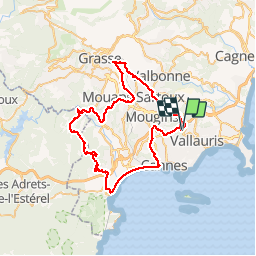
Randonnée Vélo de 67 km à découvrir à Provence-Alpes-Côte d'Azur, Alpes-Maritimes, Mougins. Cette randonnée est proposée par philsutter.
Description
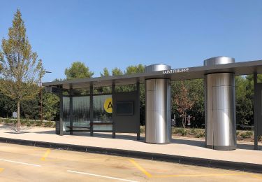
Au départ de Mougins le Haut en traversant la Valmasque, direction Valbonne, Plan de Grasse, Mouans-Sartoux, Pégomas puis montée du Tanneron jusqu'au Grand Duc pour redescendre sur Mandelieu pour prendre le bord de mer jusqu'à Cannes et remonter à Mougins.
Localisation
Commentaires
Randonnées à proximité
![Randonnée Vélo Cannes - st michel to funicular - Photo](https://media.geolcdn.com/t/375/260/ext.jpg?maxdim=2&url=https%3A%2F%2Fservices.sitytrail.com%2FGeolivesWS%2FDownloadMedia.ashx%3FTrailID%3D617439%26Media%3Dfix__20160819180717.jpg)
![Vélo Vélo](https://static1.geolcdn.com/sitytour/trail-icons/200.png)
Vélo
![](/images/other/stat-length.png)
![](https://static1.geolcdn.com/siteimages/upload/files/16400158638029165_repeat_loop_refresh_sync_direction_icon.png)
![Randonnée A pied Biot - Sentier de la Vallée de la Brague - Photo](https://media.geolcdn.com/t/375/260/69d5693d-b435-48ea-9803-59cdfb2bd33a.jpeg&format=jpg&maxdim=2)
![A pied A pied](https://static1.geolcdn.com/sitytour/trail-icons/100.png)
A pied
![](/images/other/stat-length.png)
![](https://static1.geolcdn.com/siteimages/upload/files/16400158638029165_repeat_loop_refresh_sync_direction_icon.png)
![Randonnée A pied Valbonne - Circuit des Bouillides - Photo](https://media.geolcdn.com/t/375/260/83f1adf9-9b71-481b-afb6-9317825a7553.jpeg&format=jpg&maxdim=2)
![A pied A pied](https://static1.geolcdn.com/sitytour/trail-icons/100.png)
A pied
![](/images/other/stat-length.png)
![](https://static1.geolcdn.com/siteimages/upload/files/16400158638029165_repeat_loop_refresh_sync_direction_icon.png)
![Randonnée A pied Valbonne - Circuit de l'Aqueduc - Photo](https://media.geolcdn.com/t/375/260/98799c39-3904-4577-9867-09b461856d10.jpeg&format=jpg&maxdim=2)
![A pied A pied](https://static1.geolcdn.com/sitytour/trail-icons/100.png)
A pied
![](/images/other/stat-length.png)
![](https://static1.geolcdn.com/siteimages/upload/files/16400158638029165_repeat_loop_refresh_sync_direction_icon.png)
![Randonnée A pied Biot - Circuit de Saint-Philippe - Photo](https://media.geolcdn.com/t/375/260/4ea5c2a5-8352-4835-88c7-4e46e7f4f872.jpeg&format=jpg&maxdim=2)
![A pied A pied](https://static1.geolcdn.com/sitytour/trail-icons/100.png)
A pied
![](/images/other/stat-length.png)
![](https://static1.geolcdn.com/siteimages/upload/files/16400158638029165_repeat_loop_refresh_sync_direction_icon.png)
![Randonnée A pied Biot - Circuit des Pierres à Four - Photo](https://media.geolcdn.com/t/375/260/4ea5c2a5-8352-4835-88c7-4e46e7f4f872.jpeg&format=jpg&maxdim=2)
![A pied A pied](https://static1.geolcdn.com/sitytour/trail-icons/100.png)
A pied
![](/images/other/stat-length.png)
![](https://static1.geolcdn.com/siteimages/upload/files/16400158638029165_repeat_loop_refresh_sync_direction_icon.png)
![Randonnée V.T.T. Valbonne - Valmasques pistes carton, Devens, des Moulins... - Photo](https://media.geolcdn.com/t/375/260/ext.jpg?maxdim=2&url=https%3A%2F%2Fstatic1.geolcdn.com%2Fsiteimages%2Fupload%2Ffiles%2F1524743154velo.jpg)
![V.T.T. V.T.T.](https://static1.geolcdn.com/sitytour/trail-icons/202.png)
V.T.T.
![](/images/other/stat-length.png)
![](https://static1.geolcdn.com/siteimages/upload/files/16400158638029165_repeat_loop_refresh_sync_direction_icon.png)
![Randonnée Marche Le Cannet - Sur les pas de Bonnard, Le Cannet - Photo](https://media.geolcdn.com/t/375/260/912049f5-6832-4114-95a4-305d08e71f05.jpg&format=jpg&maxdim=2)
![Marche Marche](https://static1.geolcdn.com/sitytour/trail-icons/101.png)
Marche
![](/images/other/stat-length.png)
![](https://static1.geolcdn.com/siteimages/upload/files/16400158638029165_repeat_loop_refresh_sync_direction_icon.png)
![Randonnée sport Mougins - Le long du canal de la Siagne (une partie) - Photo](https://media.geolcdn.com/t/375/260/4d0c3f2a-5e8d-470f-a038-a129b60e8cd6.jpg&format=jpg&maxdim=2)
sport
![](/images/other/stat-length.png)
![](https://static1.geolcdn.com/siteimages/upload/files/16400158638029165_repeat_loop_refresh_sync_direction_icon.png)