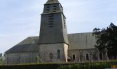

Le circuit Jean Follain - Canisy

tracegps
Utilisateur

Longueur
9,2 km

Altitude max
118 m

Dénivelé positif
126 m

Km-Effort
10,9 km

Altitude min
51 m

Dénivelé négatif
125 m
Boucle
Oui
Date de création :
2014-12-10 00:00:00.0
Dernière modification :
2014-12-10 00:00:00.0
2h19
Difficulté : Moyen

Application GPS de randonnée GRATUITE
À propos
Randonnée Marche de 9,2 km à découvrir à Normandie, Manche, Canisy. Cette randonnée est proposée par tracegps.
Description
Circuit proposé par la communauté de communes du canton de Canisy et la commune de Canisy. Départ de Canisy. Retrouvez le descriptif et la plan du circuit sur le site de la commune de Canisy.
Localisation
Pays :
France
Région :
Normandie
Département/Province :
Manche
Commune :
Canisy
Localité :
Canisy
Départ:(Dec)
Départ:(UTM)
633281 ; 5437485 (30U) N.
Commentaires
Randonnées à proximité
Balade St-Gillaise - St-Gilles


V.T.T.
Moyen
(1)
Saint-Gilles,
Normandie,
Manche,
France

23 km | 28 km-effort
2h 30min
Oui
St Gilles Château de Canisy


Marche
Très facile
Saint-Gilles,
Normandie,
Manche,
France

9 km | 10,7 km-effort
2h 26min
Oui
L'Agnelaise 2014 - Agneaux


V.T.T.
Difficile
Agneaux,
Normandie,
Manche,
France

44 km | 52 km-effort
3h 0min
Oui
Saint Martin de Bonfossé


Marche
Moyen
Saint-Martin-de-Bonfossé,
Normandie,
Manche,
France

10,1 km | 11,8 km-effort
2h 30min
Oui
La Samsonnaise 2014


V.T.T.
Difficile
Bourgvallées,
Normandie,
Manche,
France

47 km | 57 km-effort
3h 25min
Oui
Vélomaritime Cherbourg Caen #J4 20210708 Saint-Lô - Courson


Cyclotourisme
Très facile
Saint-Lô,
Normandie,
Manche,
France

44 km | 51 km-effort
Inconnu
Non

Marathon Saint Lois -Agneaux


V.T.T.
Très difficile
Agneaux,
Normandie,
Manche,
France

75 km | 92 km-effort
5h 0min
Oui

Le tour de Saint Lô en VTT


V.T.T.
Difficile
Agneaux,
Normandie,
Manche,
France

44 km | 54 km-effort
3h 0min
Oui

VTT près d'Agneaux


V.T.T.
Difficile
Agneaux,
Normandie,
Manche,
France

41 km | 49 km-effort
3h 0min
Non


 SityTrail


