![](/images/other/stat-length.png)
![Randonnée Marche Arbois - Cascade des Tufs - Arbois - Photo](https://media.geolcdn.com/t/1900/400/ext.pjpeg?maxdim=2&url=https%3A%2F%2Fservices.sitytrail.com%2FGeolivesWS%2FDownloadMedia.ashx%3FTrailID%3D129852%26Media%3D13409_4.jpg)
Cascade des Tufs - Arbois
tracegps
Utilisateur
![Longueur](/images/other/stat-length.png)
![Altitude max](https://static1.geolcdn.com/siteimages/upload/files/1508320355ic_sort_altitude_max_24dp.png)
![Dénivelé positif](https://static1.geolcdn.com/siteimages/upload/files/1508320355ic_sort_den_pos_24dp.png)
![Km-Effort](/images/other/stat-length.png)
![Altitude min](https://static1.geolcdn.com/siteimages/upload/files/1508320355ic_sort_altitude_min_24dp.png)
![Dénivelé négatif](https://static1.geolcdn.com/siteimages/upload/files/1508320355ic_sort_den_neg_24dp.png)
![Boucle](https://static1.geolcdn.com/siteimages/upload/files/16400158638029165_repeat_loop_refresh_sync_direction_icon.png)
![Marche](https://static1.geolcdn.com/sitytour/trail-icons/101.png)
2h40
Difficulté : Moyen
![Scannez ce code QR pour ouvrir la randonnée dans l'application SityTrail](https://capi.geolives.com/qq0zvz2zws4bq2lad0pu/sitytour/trails/129852/qr.png?size=200)
Application GPS de randonnée GRATUITE
À propos
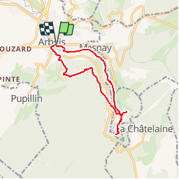
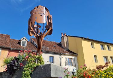
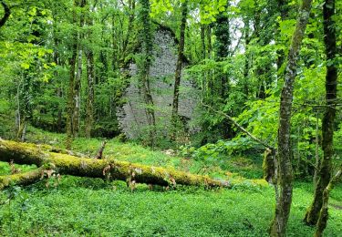
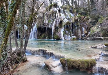
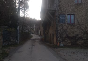
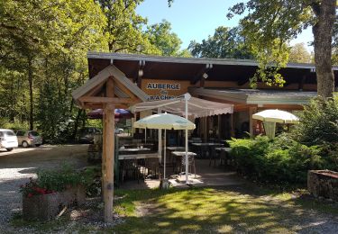
Randonnée Marche de 12,2 km à découvrir à Bourgogne-Franche-Comté, Jura, Arbois. Cette randonnée est proposée par tracegps.
Description
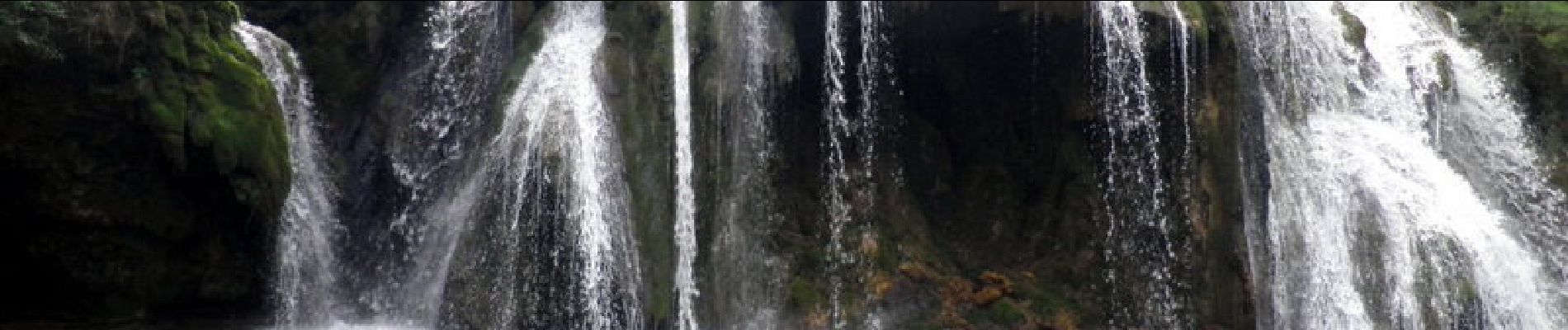
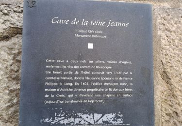
Départ parking du Champs de Mars à Arbois. Passer près de la Tour Gloriette puis monter à l'Ermitage. Suivre le GR59, le quitter pour descendre à Les Planches, aller dans la reculée pour voir la cascade des Tufs, magnifique est trop faible pour décrire cet endroit ! Retour par la petite route qui longe la Cuisance par la gauche. Cascade à voir et retour à Arbois par un quartier très ancien.
Localisation
Commentaires
Randonnées à proximité
![Randonnée Marche Arbois - Arbois Église Saint Just / Chapelle Notre Dame de l'Ermitage/ Cascade des Tufs/ Les Planches près d'Arbois / Cirque du Fer à Cheval / Belvédère de la Châtelaine/ La Roche du Feu/ Meslay/ Arbois - Photo](https://media.geolcdn.com/t/375/260/c57ab660-fec2-47a8-a9d2-fa1865f963db.jpg&format=jpg&maxdim=2)
![Marche Marche](https://static1.geolcdn.com/sitytour/trail-icons/101.png)
Marche
![](/images/other/stat-length.png)
![](https://static1.geolcdn.com/siteimages/upload/files/16400158638029165_repeat_loop_refresh_sync_direction_icon.png)
![Randonnée Marche Arbois - Arbois Pupillin Arbois - Photo](https://media.geolcdn.com/t/375/260/d8b4c5eb-e163-47d4-aaaf-96dbcfbb358f.jpg&format=jpg&maxdim=2)
![Marche Marche](https://static1.geolcdn.com/sitytour/trail-icons/101.png)
Marche
![](/images/other/stat-length.png)
![](https://static1.geolcdn.com/siteimages/upload/files/16400158638029165_repeat_loop_refresh_sync_direction_icon.png)
![Randonnée Marche Arbois - Arbois Belvédère du Fer à Cheval Belvédère Châtelaine Cascade des Tufs Planches près d'Arbois La Roche du Feu Mesnay Arbois - Photo](https://media.geolcdn.com/t/375/260/71353c7e-d6a4-47bd-b061-6c2048e62167.jpg&format=jpg&maxdim=2)
![Marche Marche](https://static1.geolcdn.com/sitytour/trail-icons/101.png)
Marche
![](/images/other/stat-length.png)
![](https://static1.geolcdn.com/siteimages/upload/files/16400158638029165_repeat_loop_refresh_sync_direction_icon.png)
![Randonnée Marche Les Planches-près-Arbois - la reculée des planches - Photo](https://media.geolcdn.com/t/375/260/54dcee1d-d6c8-429f-ae87-1dad41ae6b91.jpg&format=jpg&maxdim=2)
![Marche Marche](https://static1.geolcdn.com/sitytour/trail-icons/101.png)
Marche
![](/images/other/stat-length.png)
![](https://static1.geolcdn.com/siteimages/upload/files/16400158638029165_repeat_loop_refresh_sync_direction_icon.png)
![Randonnée Marche Arbois - Arbois Reculée des Planches - Photo](https://media.geolcdn.com/t/375/260/3029e893-3181-453d-94ab-d00d63b05373.jpg&format=jpg&maxdim=2)
![Marche Marche](https://static1.geolcdn.com/sitytour/trail-icons/101.png)
Marche
![](/images/other/stat-length.png)
![](https://static1.geolcdn.com/siteimages/upload/files/16400158638029165_repeat_loop_refresh_sync_direction_icon.png)
![Randonnée Marche Montigny-lès-Arsures - Montigny les Arsures - Photo](https://media.geolcdn.com/t/375/260/43ca39b3-8483-4e13-bdbd-587ac00b0f2b.jpg&format=jpg&maxdim=2)
![Marche Marche](https://static1.geolcdn.com/sitytour/trail-icons/101.png)
Marche
![](/images/other/stat-length.png)
![](https://static1.geolcdn.com/siteimages/upload/files/16400158638029165_repeat_loop_refresh_sync_direction_icon.png)
![Randonnée Marche La Châtelaine - Cirque du Fer à Cheval - cascade des Tufs - Arbois - Photo](https://media.geolcdn.com/t/375/260/ff46c3de-3ecb-478e-8c38-198244ccc0e5.jpg&format=jpg&maxdim=2)
![Marche Marche](https://static1.geolcdn.com/sitytour/trail-icons/101.png)
Marche
![](/images/other/stat-length.png)
![](https://static1.geolcdn.com/siteimages/upload/files/16400158638029165_repeat_loop_refresh_sync_direction_icon.png)
![Randonnée Marche La Châtelaine - les planches d'Arbois restaurant le fer à cheval - Photo](https://media.geolcdn.com/t/375/260/e63ffc4f-ef96-4146-b1da-ac690db78307.jpg&format=jpg&maxdim=2)
![Marche Marche](https://static1.geolcdn.com/sitytour/trail-icons/101.png)
Marche
![](/images/other/stat-length.png)
![](https://static1.geolcdn.com/siteimages/upload/files/16400158638029165_repeat_loop_refresh_sync_direction_icon.png)
![Randonnée Randonnée équestre Les Planches-près-Arbois - GTJ_E08 Les Planches-près-Arbois > Montchauvier - Photo](https://media.geolcdn.com/t/375/260/ext.jpg?maxdim=2&url=https%3A%2F%2Fstatic1.geolcdn.com%2Fsiteimages%2Fupload%2Ffiles%2F1524743154cheval.jpg)
![Randonnée équestre Randonnée équestre](https://static1.geolcdn.com/sitytour/trail-icons/301.png)
Randonnée équestre
![](/images/other/stat-length.png)
![](https://static1.geolcdn.com/siteimages/upload/files/16400158638029165_repeat_loop_refresh_sync_direction_icon.png)