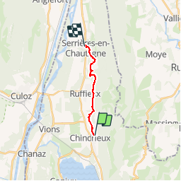
![](/images/other/stat-length.png)
![Randonnée Marche Chindrieux - Sur les Pas des Huguenots - Chindrieux - Serrières en Chautagne - Photo](https://media.geolcdn.com/t/1900/400/ext.pjpeg?maxdim=2&url=https%3A%2F%2Fservices.sitytrail.com%2FGeolivesWS%2FDownloadMedia.ashx%3FTrailID%3D129664%26Media%3D13193_3.jpg)
Sur les Pas des Huguenots - Chindrieux - Serrières en Chautagne
tracegps
Utilisateur
![Longueur](/images/other/stat-length.png)
![Altitude max](https://static1.geolcdn.com/siteimages/upload/files/1508320355ic_sort_altitude_max_24dp.png)
![Dénivelé positif](https://static1.geolcdn.com/siteimages/upload/files/1508320355ic_sort_den_pos_24dp.png)
![Km-Effort](/images/other/stat-length.png)
![Altitude min](https://static1.geolcdn.com/siteimages/upload/files/1508320355ic_sort_altitude_min_24dp.png)
![Dénivelé négatif](https://static1.geolcdn.com/siteimages/upload/files/1508320355ic_sort_den_neg_24dp.png)
![Boucle](https://static1.geolcdn.com/siteimages/upload/files/16400158638029165_repeat_loop_refresh_sync_direction_icon.png)
![Marche](https://static1.geolcdn.com/sitytour/trail-icons/101.png)
3h00
Difficulté : Moyen
![Scannez ce code QR pour ouvrir la randonnée dans l'application SityTrail](https://capi.geolives.com/qq0zvz2zws4bq2lad0pu/sitytour/trails/129664/qr.png?size=200)
Application GPS de randonnée GRATUITE
À propos
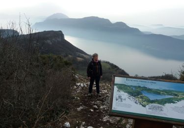
Randonnée Marche de 9,2 km à découvrir à Auvergne-Rhône-Alpes, Savoie, Chindrieux. Cette randonnée est proposée par tracegps.
Description
« Sur les pas des Huguenots » consiste en la création d'un sentier international de grande randonnée suivant le tracé historique de l'exil des Huguenots dauphinois vers l'Allemagne et la Suisse après la révocation de l'Edit de Nantes (1685-1690), ainsi que la création de deux itinéraires de l'Italie vers la Suisse, l'exode et la Glorieuse Rentrée des Vaudois du Piémont.
Localisation
Commentaires
Randonnées à proximité
![Randonnée Marche Massingy - CLERGEON - Photo](https://media.geolcdn.com/t/375/260/ext.jpg?maxdim=2&url=https%3A%2F%2Fservices.sitytrail.com%2FGeolivesWS%2FDownloadMedia.ashx%3FTrailID%3D474185%26Media%3Dc01eb5a7-bf72-4ffc-98fa-1e923f8f3f43.jpg)
![Marche Marche](https://static1.geolcdn.com/sitytour/trail-icons/101.png)
Marche
![](/images/other/stat-length.png)
![](https://static1.geolcdn.com/siteimages/upload/files/16400158638029165_repeat_loop_refresh_sync_direction_icon.png)
![Randonnée Marche Entrelacs - SAPENAY / CLERGEON: GRANDE CUVE - Photo](https://media.geolcdn.com/t/375/260/81ea709e-f7b9-477c-93c3-923ab4e12c63.jpg&format=jpg&maxdim=2)
![Marche Marche](https://static1.geolcdn.com/sitytour/trail-icons/101.png)
Marche
![](/images/other/stat-length.png)
![](https://static1.geolcdn.com/siteimages/upload/files/16400158638029165_repeat_loop_refresh_sync_direction_icon.png)
![Randonnée Marche Entrelacs - La chambotte mont laval aix les bains - Photo](https://media.geolcdn.com/t/375/260/83780321-69f1-4ca1-9229-55e6ffa1c410.jpg&format=jpg&maxdim=2)
![Marche Marche](https://static1.geolcdn.com/sitytour/trail-icons/101.png)
Marche
![](/images/other/stat-length.png)
![](https://static1.geolcdn.com/siteimages/upload/files/16400158638029165_repeat_loop_refresh_sync_direction_icon.png)
![Randonnée Marche Chanaz - SAVOIE: CHANAZ - SAINT PIERRE DE CURTILLE - JONGIEUX - Photo](https://media.geolcdn.com/t/375/260/a2c9fd3e-2c40-420b-9198-d6795b6e7119.jpg&format=jpg&maxdim=2)
![Marche Marche](https://static1.geolcdn.com/sitytour/trail-icons/101.png)
Marche
![](/images/other/stat-length.png)
![](https://static1.geolcdn.com/siteimages/upload/files/16400158638029165_repeat_loop_refresh_sync_direction_icon.png)
![Randonnée Marche Entrelacs - CHAMBOTTE: DECRASSAGE SUR LES CRETES - Photo](https://media.geolcdn.com/t/375/260/ddde69c3-3462-4077-ba6c-e835ee2db56d.jpg&format=jpg&maxdim=2)
![Marche Marche](https://static1.geolcdn.com/sitytour/trail-icons/101.png)
Marche
![](/images/other/stat-length.png)
![](https://static1.geolcdn.com/siteimages/upload/files/16400158638029165_repeat_loop_refresh_sync_direction_icon.png)
![Randonnée Marche Chindrieux - SAPENAY / CLERGEON: COL DU SAPENAY - ROJUX - GRANDE CUVE - MONTCLERGEON - Photo](https://media.geolcdn.com/t/375/260/ec0fabdb-a998-4b52-ac46-d11021fde1e5.jpg&format=jpg&maxdim=2)
![Marche Marche](https://static1.geolcdn.com/sitytour/trail-icons/101.png)
Marche
![](/images/other/stat-length.png)
![](https://static1.geolcdn.com/siteimages/upload/files/16400158638029165_repeat_loop_refresh_sync_direction_icon.png)
![Randonnée Marche Entrelacs - SAPENAY: MONTAGNE DE CESSENS - Photo](https://media.geolcdn.com/t/375/260/cae53790-ce06-4ff8-a857-f0d1206d4970.jpg&format=jpg&maxdim=2)
![Marche Marche](https://static1.geolcdn.com/sitytour/trail-icons/101.png)
Marche
![](/images/other/stat-length.png)
![](https://static1.geolcdn.com/siteimages/upload/files/16400158638029165_repeat_loop_refresh_sync_direction_icon.png)
![Randonnée Marche Chindrieux - SAPENAY / CLERGEON: COL DU SAPENAY - MONTCLERGEON PAR LE SENTIER DES VACHES (en live) - Photo](https://media.geolcdn.com/t/375/260/3c03cb4b-fb8a-4c79-83a1-ad8f3ccbc05c.jpg&format=jpg&maxdim=2)
![Marche Marche](https://static1.geolcdn.com/sitytour/trail-icons/101.png)
Marche
![](/images/other/stat-length.png)
![](https://static1.geolcdn.com/siteimages/upload/files/16400158638029165_repeat_loop_refresh_sync_direction_icon.png)
![Randonnée Marche Entrelacs - SAPENAY / CLERGEON: COL DU SAPENAY - GRANDE CUVE directissime - Photo](https://media.geolcdn.com/t/375/260/410c440e-545c-4327-974f-255c4304a936.jpg&format=jpg&maxdim=2)
![Marche Marche](https://static1.geolcdn.com/sitytour/trail-icons/101.png)
Marche
![](/images/other/stat-length.png)
![](https://static1.geolcdn.com/siteimages/upload/files/16400158638029165_repeat_loop_refresh_sync_direction_icon.png)