![](/images/other/stat-length.png)
![Randonnée Marche Cuzion - Pont des Piles - Crozant - Photo](https://media.geolcdn.com/t/1900/400/ext.pjpeg?maxdim=2&url=https%3A%2F%2Fservices.sitytrail.com%2FGeolivesWS%2FDownloadMedia.ashx%3FTrailID%3D129658%26Media%3D13186_4.jpg)
Pont des Piles - Crozant
tracegps
Utilisateur
![Longueur](/images/other/stat-length.png)
![Altitude max](https://static1.geolcdn.com/siteimages/upload/files/1508320355ic_sort_altitude_max_24dp.png)
![Dénivelé positif](https://static1.geolcdn.com/siteimages/upload/files/1508320355ic_sort_den_pos_24dp.png)
![Km-Effort](/images/other/stat-length.png)
![Altitude min](https://static1.geolcdn.com/siteimages/upload/files/1508320355ic_sort_altitude_min_24dp.png)
![Dénivelé négatif](https://static1.geolcdn.com/siteimages/upload/files/1508320355ic_sort_den_neg_24dp.png)
![Boucle](https://static1.geolcdn.com/siteimages/upload/files/16400158638029165_repeat_loop_refresh_sync_direction_icon.png)
![Marche](https://static1.geolcdn.com/sitytour/trail-icons/101.png)
7h00
Difficulté : Moyen
![Scannez ce code QR pour ouvrir la randonnée dans l'application SityTrail](https://capi.geolives.com/qq0zvz2zws4bq2lad0pu/sitytour/trails/129658/qr.png?size=200)
Application GPS de randonnée GRATUITE
À propos
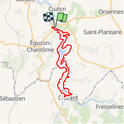
Randonnée Marche de 29 km à découvrir à Centre-Val de Loire, Indre, Cuzion. Cette randonnée est proposée par tracegps.
Description
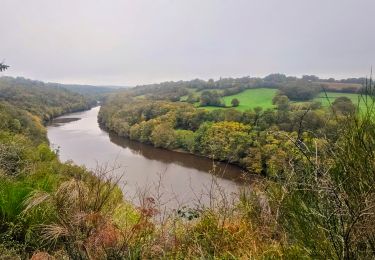
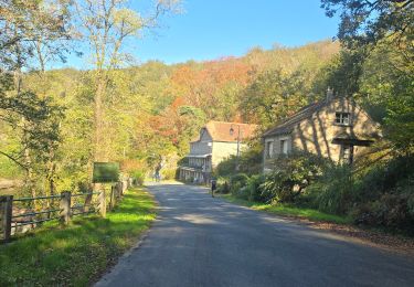
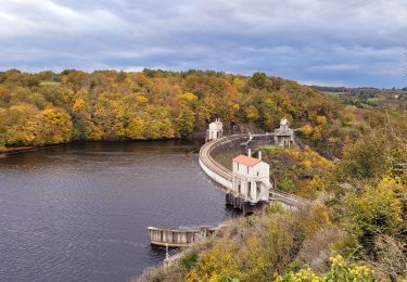
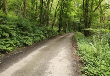
A la limite entre Berry et Limousin, grande randonnée, facile mais longue, entièrement sur sentier balisé (GR rouge et blanc ou GR de pays jaune et rouge). Inutile d'acheter les 4 cartes IGN : une bonne carte raster sur le GPS suffit. Les portions de goudron se font vite oublier quand on découvre la beauté des rives de la Creuse ou quand au détour du sentier, on découvre les ruines du château de Crozant sur un piton entre Creuse et Sedelle. (Les ruines se visitent de Pâques à la Toussaint).
Localisation
Commentaires
Randonnées à proximité
![Randonnée A pied Cuzion - Eguzon Rando 2 ème jour - Photo](https://media.geolcdn.com/t/375/260/a7bc871c-b682-4a60-ba19-c61ac5b978f2.jpg&format=jpg&maxdim=2)
![A pied A pied](https://static1.geolcdn.com/sitytour/trail-icons/100.png)
A pied
![](/images/other/stat-length.png)
![](https://static1.geolcdn.com/siteimages/upload/files/16400158638029165_repeat_loop_refresh_sync_direction_icon.png)
![Randonnée Marche Éguzon-Chantôme - SityTrail - Eguzon - la Feyte barrage d'Eguzon - Photo](https://media.geolcdn.com/t/375/260/ext.jpg?maxdim=2&url=https%3A%2F%2Fstatic1.geolcdn.com%2Fsiteimages%2Fupload%2Ffiles%2F1553511878bg_sport_marche.png)
![Marche Marche](https://static1.geolcdn.com/sitytour/trail-icons/101.png)
Marche
![](/images/other/stat-length.png)
![](https://static1.geolcdn.com/siteimages/upload/files/16400158638029165_repeat_loop_refresh_sync_direction_icon.png)
![Randonnée Marche Saint-Plantaire - SityTrail - Fougères Rochers de la Fileuse sentier des arts - Photo](https://media.geolcdn.com/t/375/260/ext.jpg?maxdim=2&url=https%3A%2F%2Fstatic1.geolcdn.com%2Fsiteimages%2Fupload%2Ffiles%2F1553511878bg_sport_marche.png)
![Marche Marche](https://static1.geolcdn.com/sitytour/trail-icons/101.png)
Marche
![](/images/other/stat-length.png)
![](https://static1.geolcdn.com/siteimages/upload/files/16400158638029165_repeat_loop_refresh_sync_direction_icon.png)
![Randonnée Marche Cuzion - Eguzon Fête de la chataigne 33 km 2024 - Photo](https://media.geolcdn.com/t/375/260/f745763e-682a-46d9-a239-82fde3008c2e.jpg&format=jpg&maxdim=2)
![Marche Marche](https://static1.geolcdn.com/sitytour/trail-icons/101.png)
Marche
![](/images/other/stat-length.png)
![](https://static1.geolcdn.com/siteimages/upload/files/16400158638029165_repeat_loop_refresh_sync_direction_icon.png)
![Randonnée Marche Éguzon-Chantôme - Eguzon Fête de la Chataigne Rando nocturne bienvenue - Photo](https://media.geolcdn.com/t/375/260/24d6660c-fb58-48b3-a67a-2af016161c12.jpg&format=jpg&maxdim=2)
![Marche Marche](https://static1.geolcdn.com/sitytour/trail-icons/101.png)
Marche
![](/images/other/stat-length.png)
![](https://static1.geolcdn.com/siteimages/upload/files/16400158638029165_repeat_loop_refresh_sync_direction_icon.png)
![Randonnée Marche Cuzion - Eguzon - Circuit J2 30 km - Photo](https://media.geolcdn.com/t/375/260/59880018-4b9c-4080-8bf6-02bca82137b1.jpg&format=jpg&maxdim=2)
![Marche Marche](https://static1.geolcdn.com/sitytour/trail-icons/101.png)
Marche
![](/images/other/stat-length.png)
![](https://static1.geolcdn.com/siteimages/upload/files/16400158638029165_repeat_loop_refresh_sync_direction_icon.png)
![Randonnée Marche Cuzion - eguzon fete de la chataigne j 1 - Photo](https://media.geolcdn.com/t/375/260/70975040-8803-493d-a30f-e415896ba7b2.jpg&format=jpg&maxdim=2)
![Marche Marche](https://static1.geolcdn.com/sitytour/trail-icons/101.png)
Marche
![](/images/other/stat-length.png)
![](https://static1.geolcdn.com/siteimages/upload/files/16400158638029165_repeat_loop_refresh_sync_direction_icon.png)
![Randonnée Marche Éguzon-Chantôme - eguzon j1- Balade de bienvenue - Photo](https://media.geolcdn.com/t/375/260/fd0ffebb-99b7-44d3-b177-f38e3091c1d0.jpg&format=jpg&maxdim=2)
![Marche Marche](https://static1.geolcdn.com/sitytour/trail-icons/101.png)
Marche
![](/images/other/stat-length.png)
![](https://static1.geolcdn.com/siteimages/upload/files/16400158638029165_repeat_loop_refresh_sync_direction_icon.png)
![Randonnée Marche Cuzion - la passerelle de casse cou - Photo](https://media.geolcdn.com/t/375/260/98273f83-f83d-4b56-b57b-cbcbe74e1018.jpg&format=jpg&maxdim=2)
![Marche Marche](https://static1.geolcdn.com/sitytour/trail-icons/101.png)
Marche
![](/images/other/stat-length.png)
![](https://static1.geolcdn.com/siteimages/upload/files/16400158638029165_repeat_loop_refresh_sync_direction_icon.png)