![](/images/other/stat-length.png)
![Randonnée Marche Thiézac - La Porte du Lion - Thiézac - Photo](https://media.geolcdn.com/t/1900/400/ext.pjpeg?maxdim=2&url=https%3A%2F%2Fservices.sitytrail.com%2FGeolivesWS%2FDownloadMedia.ashx%3FTrailID%3D129644%26Media%3D13165_3.jpg)
La Porte du Lion - Thiézac
tracegps
Utilisateur
![Longueur](/images/other/stat-length.png)
![Altitude max](https://static1.geolcdn.com/siteimages/upload/files/1508320355ic_sort_altitude_max_24dp.png)
![Dénivelé positif](https://static1.geolcdn.com/siteimages/upload/files/1508320355ic_sort_den_pos_24dp.png)
![Km-Effort](/images/other/stat-length.png)
![Altitude min](https://static1.geolcdn.com/siteimages/upload/files/1508320355ic_sort_altitude_min_24dp.png)
![Dénivelé négatif](https://static1.geolcdn.com/siteimages/upload/files/1508320355ic_sort_den_neg_24dp.png)
![Boucle](https://static1.geolcdn.com/siteimages/upload/files/16400158638029165_repeat_loop_refresh_sync_direction_icon.png)
![Marche](https://static1.geolcdn.com/sitytour/trail-icons/101.png)
3h00
Difficulté : Moyen
![Scannez ce code QR pour ouvrir la randonnée dans l'application SityTrail](https://capi.geolives.com/qq0zvz2zws4bq2lad0pu/sitytour/trails/129644/qr.png?size=200)
Application GPS de randonnée GRATUITE
À propos
Randonnée Marche de 6,6 km à découvrir à Auvergne-Rhône-Alpes, Cantal, Thiézac. Cette randonnée est proposée par tracegps.
Description
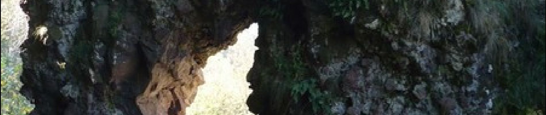
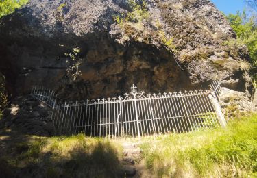
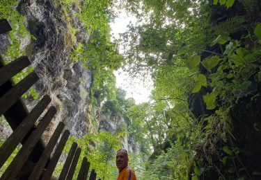
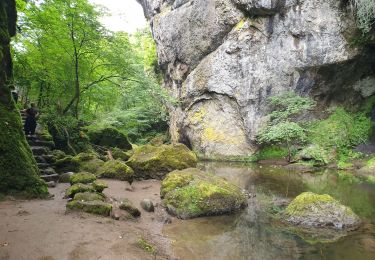
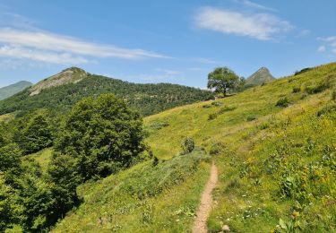
Le site de la Porte du Lion (ou le Chaos de Casteltinet) est issu de l'activité volcanique. C'est un amas de blocs de gneiss volcaniques très impressionnant. Circuit inscrit au Plan Départemental des Itinéraires de Petites Randonnées. Balisage : Jaune Départ : à Thiézac, suivre la direction du camping municipal. Une fois sur le pont enjambant la rivière Cère, tourner à gauche, puis suivre la direction de Lagoutte. Chiens déconseillés, en raison des troupeaux de vaches en pâture.
Localisation
Commentaires
Randonnées à proximité
![Marche Marche](https://static1.geolcdn.com/sitytour/trail-icons/101.png)
Marche
![](/images/other/stat-length.png)
![](https://static1.geolcdn.com/siteimages/upload/files/16400158638029165_repeat_loop_refresh_sync_direction_icon.png)
![Randonnée V.T.C. Mandailles-Saint-Julien - Tournemire - Photo](https://media.geolcdn.com/t/375/260/e14f03b2-11fc-4b1e-a416-809203cb4d66.jpg&format=jpg&maxdim=2)
![V.T.C. V.T.C.](https://static1.geolcdn.com/sitytour/trail-icons/203.png)
V.T.C.
![](/images/other/stat-length.png)
![](https://static1.geolcdn.com/siteimages/upload/files/16400158638029165_repeat_loop_refresh_sync_direction_icon.png)
![Randonnée Marche Thiézac - Puy de la poche - Photo](https://media.geolcdn.com/t/375/260/f3ce84a8-7fd4-461e-ae03-56b4255cfce0.jpg&format=jpg&maxdim=2)
![Marche Marche](https://static1.geolcdn.com/sitytour/trail-icons/101.png)
Marche
![](/images/other/stat-length.png)
![](https://static1.geolcdn.com/siteimages/upload/files/16400158638029165_repeat_loop_refresh_sync_direction_icon.png)
![Randonnée Marche Thiézac - La porte du Lion - Thiézac - Photo](https://media.geolcdn.com/t/375/260/ext.jpg?maxdim=2&url=https%3A%2F%2Fstatic1.geolcdn.com%2Fsiteimages%2Fupload%2Ffiles%2F1553511878bg_sport_marche.png)
![Marche Marche](https://static1.geolcdn.com/sitytour/trail-icons/101.png)
Marche
![](/images/other/stat-length.png)
![](https://static1.geolcdn.com/siteimages/upload/files/16400158638029165_repeat_loop_refresh_sync_direction_icon.png)
![Randonnée Trail Vic-sur-Cère - Cascade, la Garde, grotte des anglais - Photo](https://media.geolcdn.com/t/375/260/2f654d5e-2308-4101-8214-c057fbfbda64.jpg&format=jpg&maxdim=2)
![Trail Trail](https://static1.geolcdn.com/sitytour/trail-icons/104.png)
Trail
![](/images/other/stat-length.png)
![](https://static1.geolcdn.com/siteimages/upload/files/16400158638029165_repeat_loop_refresh_sync_direction_icon.png)
![Randonnée Marche Vic-sur-Cère - Pas de Cère- cascade de Gourdole - Photo](https://media.geolcdn.com/t/375/260/88d7000e-837e-4895-ace1-8d40f2abe4ca.jpg&format=jpg&maxdim=2)
![Marche Marche](https://static1.geolcdn.com/sitytour/trail-icons/101.png)
Marche
![](/images/other/stat-length.png)
![](https://static1.geolcdn.com/siteimages/upload/files/16400158638029165_repeat_loop_refresh_sync_direction_icon.png)
![Randonnée Marche Thiézac - Les Gorges du Pas de Cère - Photo](https://media.geolcdn.com/t/375/260/fa38157b-57d6-4ad3-89fe-dcb1d3174ee5.jpg&format=jpg&maxdim=2)
![Marche Marche](https://static1.geolcdn.com/sitytour/trail-icons/101.png)
Marche
![](/images/other/stat-length.png)
![](https://static1.geolcdn.com/siteimages/upload/files/16400158638029165_repeat_loop_refresh_sync_direction_icon.png)
![Randonnée Marche Saint-Jacques-des-Blats - Grange Dévézou col du Pertus par col du Gliziou - Photo](https://media.geolcdn.com/t/375/260/879f5322-0936-4ccc-9e2f-1ca15de75463.jpg&format=jpg&maxdim=2)
![Marche Marche](https://static1.geolcdn.com/sitytour/trail-icons/101.png)
Marche
![](/images/other/stat-length.png)
![](https://static1.geolcdn.com/siteimages/upload/files/16400158638029165_repeat_loop_refresh_sync_direction_icon.png)
![Randonnée Marche Thiézac - Moulin de Nierveze La grange de Dévézou - Photo](https://media.geolcdn.com/t/375/260/2366ecda-4615-4aaa-8890-5175d569027c.jpg&format=jpg&maxdim=2)
![Marche Marche](https://static1.geolcdn.com/sitytour/trail-icons/101.png)
Marche
![](/images/other/stat-length.png)
![](https://static1.geolcdn.com/siteimages/upload/files/16400158638029165_repeat_loop_refresh_sync_direction_icon.png)