![](/images/other/stat-length.png)
![Randonnée Marche Lauris - Lauris La forêt de Cèdres - Photo](https://media.geolcdn.com/t/1900/400/ext.pjpeg?maxdim=2&url=https%3A%2F%2Fstatic1.geolcdn.com%2Fsiteimages%2Fupload%2Ffiles%2F1553511878bg_sport_marche.png)
Lauris La forêt de Cèdres
Elidabeth
Utilisateur
![Longueur](/images/other/stat-length.png)
Longueur
16,2 km
![Altitude max](https://static1.geolcdn.com/siteimages/upload/files/1508320355ic_sort_altitude_max_24dp.png)
Altitude max
723 m
![Dénivelé positif](https://static1.geolcdn.com/siteimages/upload/files/1508320355ic_sort_den_pos_24dp.png)
Dénivelé positif
488 m
![Km-Effort](/images/other/stat-length.png)
Km-Effort
23 km
![Altitude min](https://static1.geolcdn.com/siteimages/upload/files/1508320355ic_sort_altitude_min_24dp.png)
Altitude min
249 m
![Dénivelé négatif](https://static1.geolcdn.com/siteimages/upload/files/1508320355ic_sort_den_neg_24dp.png)
Dénivelé négatif
489 m
![Boucle](https://static1.geolcdn.com/siteimages/upload/files/16400158638029165_repeat_loop_refresh_sync_direction_icon.png)
Boucle
Oui
Date de création :
2014-12-10 00:00:00.0
Dernière modification :
2014-12-10 00:00:00.0
![Marche](https://static1.geolcdn.com/sitytour/trail-icons/101.png)
4h31
Difficulté : Moyen
![Scannez ce code QR pour ouvrir la randonnée dans l'application SityTrail](https://capi.geolives.com/qq0zvz2zws4bq2lad0pu/sitytour/trails/127469/qr.png?size=200)
Application GPS de randonnée GRATUITE
À propos
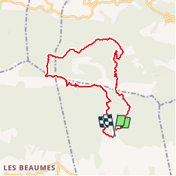
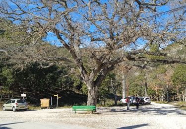
Randonnée Marche de 16,2 km à découvrir à Provence-Alpes-Côte d'Azur, Vaucluse, Lauris. Cette randonnée est proposée par Elidabeth.
Description
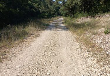
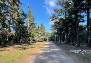
DDépart de parking proximité mas dde Recaute, gr puis forêt de CCèdres Tour philippe, combe du sautadou. Beaucoup de charme à ddécouvrir au printemps, fleurs,et chants d'oiseaux.
Localisation
Pays :
France
Région :
Provence-Alpes-Côte d'Azur
Département/Province :
Vaucluse
Commune :
Lauris
Localité :
Unknown
Départ:(Dec)
Départ:(UTM)
685092 ; 4849077 (31T) N.
Commentaires
Randonnées à proximité
![Marche Marche](https://static1.geolcdn.com/sitytour/trail-icons/101.png)
PF-Lauris - Circuit de Recaute
Marche
Moyen
(1)
Lauris,
Provence-Alpes-Côte d'Azur,
Vaucluse,
France
![](/images/other/stat-length.png)
6 km | 8,6 km-effort
2h 28min
![](https://static1.geolcdn.com/siteimages/upload/files/16400158638029165_repeat_loop_refresh_sync_direction_icon.png)
Oui
![Randonnée Marche Bonnieux - Forêt de Cêdre - Roque des Bancs - Baume Rousse - Grottes de Font Scure et des Vaudois - Le Portalas - Photo](https://media.geolcdn.com/t/375/260/ext.jpg?maxdim=2&url=https%3A%2F%2Fservices.sitytrail.com%2FGeolivesWS%2FDownloadMedia.ashx%3FTrailID%3D103432%26Media%3D5548_1.jpg)
![Marche Marche](https://static1.geolcdn.com/sitytour/trail-icons/101.png)
Forêt de Cêdre - Roque des Bancs - Baume Rousse - Grottes de Font Scure et de...
Marche
Moyen
(5)
Bonnieux,
Provence-Alpes-Côte d'Azur,
Vaucluse,
France
![](/images/other/stat-length.png)
9,3 km | 14,2 km-effort
4h 0min
![](https://static1.geolcdn.com/siteimages/upload/files/16400158638029165_repeat_loop_refresh_sync_direction_icon.png)
Oui
![Randonnée A pied Bonnieux - foret-des-cedres-bonnieux-Portalas - Photo](https://media.geolcdn.com/t/375/260/ext.jpg?maxdim=2&url=https%3A%2F%2Fstatic1.geolcdn.com%2Fsiteimages%2Fupload%2Ffiles%2F1545311037marcheuse_200dpi.jpg)
![A pied A pied](https://static1.geolcdn.com/sitytour/trail-icons/100.png)
foret-des-cedres-bonnieux-Portalas
A pied
Moyen
(1)
Bonnieux,
Provence-Alpes-Côte d'Azur,
Vaucluse,
France
![](/images/other/stat-length.png)
14,8 km | 24 km-effort
5h 28min
![](https://static1.geolcdn.com/siteimages/upload/files/16400158638029165_repeat_loop_refresh_sync_direction_icon.png)
Oui
![Marche Marche](https://static1.geolcdn.com/sitytour/trail-icons/101.png)
PF-Bonnieux - De la Sanguinette à la Roque des Bancs
Marche
Difficile
Bonnieux,
Provence-Alpes-Côte d'Azur,
Vaucluse,
France
![](/images/other/stat-length.png)
9,2 km | 13,7 km-effort
2h 57min
![](https://static1.geolcdn.com/siteimages/upload/files/16400158638029165_repeat_loop_refresh_sync_direction_icon.png)
Oui
![Randonnée Marche Lauris - reco lauris tp - Photo](https://media.geolcdn.com/t/375/260/5929b2a5-8eac-429a-91c5-dd7d6b103406.jpg&format=jpg&maxdim=2)
![Marche Marche](https://static1.geolcdn.com/sitytour/trail-icons/101.png)
reco lauris tp
Marche
Moyen
Lauris,
Provence-Alpes-Côte d'Azur,
Vaucluse,
France
![](/images/other/stat-length.png)
8,5 km | 12,7 km-effort
2h 25min
![](https://static1.geolcdn.com/siteimages/upload/files/16400158638029165_repeat_loop_refresh_sync_direction_icon.png)
Oui
![Randonnée A pied Lourmarin - Lourmarin - Cadenet - Lourmarin - Photo](https://media.geolcdn.com/t/375/260/2d53adfc-3504-4117-a8f3-d2bec3eead0d.jpg&format=jpg&maxdim=2)
![A pied A pied](https://static1.geolcdn.com/sitytour/trail-icons/100.png)
Lourmarin - Cadenet - Lourmarin
A pied
Facile
Lourmarin,
Provence-Alpes-Côte d'Azur,
Vaucluse,
France
![](/images/other/stat-length.png)
11,5 km | 14,6 km-effort
3h 19min
![](https://static1.geolcdn.com/siteimages/upload/files/16400158638029165_repeat_loop_refresh_sync_direction_icon.png)
Oui
![Marche Marche](https://static1.geolcdn.com/sitytour/trail-icons/101.png)
PF-Bonnieux - Massif des Cèdres - Roque des Bancs - Les Portalas - AT
Marche
Moyen
Bonnieux,
Provence-Alpes-Côte d'Azur,
Vaucluse,
France
![](/images/other/stat-length.png)
8,6 km | 11,4 km-effort
2h 35min
![](https://static1.geolcdn.com/siteimages/upload/files/16400158638029165_repeat_loop_refresh_sync_direction_icon.png)
Oui
![Randonnée Marche Lauris - PF-Lauris - Bigonce - Recaute - 18.02.2022 - MM - Photo](https://media.geolcdn.com/t/375/260/3ecf0c6e-bed2-46dd-a724-d9ca8bbe61b3.jpg&format=jpg&maxdim=2)
![Marche Marche](https://static1.geolcdn.com/sitytour/trail-icons/101.png)
PF-Lauris - Bigonce - Recaute - 18.02.2022 - MM
Marche
Moyen
Lauris,
Provence-Alpes-Côte d'Azur,
Vaucluse,
France
![](/images/other/stat-length.png)
5,9 km | 8,4 km-effort
1h 54min
![](https://static1.geolcdn.com/siteimages/upload/files/16400158638029165_repeat_loop_refresh_sync_direction_icon.png)
Oui
![Randonnée V.T.T. Lauris - GTVAU-J7 variante - Photo](https://media.geolcdn.com/t/375/260/ext.jpg?maxdim=2&url=https%3A%2F%2Fstatic1.geolcdn.com%2Fsiteimages%2Fupload%2Ffiles%2F1524743154velo.jpg)
![V.T.T. V.T.T.](https://static1.geolcdn.com/sitytour/trail-icons/202.png)
GTVAU-J7 variante
V.T.T.
Très facile
(1)
Lauris,
Provence-Alpes-Côte d'Azur,
Vaucluse,
France
![](/images/other/stat-length.png)
47 km | 65 km-effort
Inconnu
![](https://static1.geolcdn.com/siteimages/upload/files/16400158638029165_repeat_loop_refresh_sync_direction_icon.png)
Non