Randonnée Autre activité The Municipal District of Baltinglass - Randoguide - Photo
 frankcow
frankcow

Utilisateur

© OpenStreetMap contributors
Longueur
Longueur
15,7 km
Altitude max
Altitude max
700 m
Dénivelé positif
Dénivelé positif
617 m
Km-Effort
Km-Effort  
24 km
Altitude min
Altitude min
184 m
Dénivelé négatif
Dénivelé négatif
660 m
Boucle
Boucle
Non
Date de création :
2014-12-10 00:00:00.0
Dernière modification :
2014-12-10 00:00:00.0

(0 Avis)

Autre activité
Autre activité
--
Difficulté : Moyen

Scannez ce code QR pour ouvrir la randonnée dans l'application SityTrail

Application GPS de randonnée GRATUITE

Logo SityTrail SityTrail

IGN / Instituts géographiques

Télécharger SityTrail sur l'App Store Télécharger SityTrail sur Google Play

Logo SityTrail SityTrail World

Le monde est à vous

Télécharger SityTrail sur l'App Store Télécharger SityTrail sur Google Play Télécharger SityTrail sur Huawei AppGallery

À propos

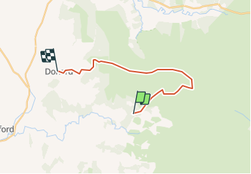
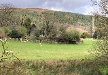
Randonnée Autre activité de 15,7 km à découvrir à Inconnu, County Wicklow, The Municipal District of Baltinglass. Cette randonnée est proposée par frankcow.

Profil altimétrique

Localisation

Pays :
Irlande
Région :
Inconnu
Département/Province :
County Wicklow
Commune :
The Municipal District of Baltinglass
Localité :
Imael North
Départ:(Dec)
Départ:(UTM)
665152 ; 5874782 (29U) N.

Randonnées à proximité

Randonnée Marche The Municipal District of Wicklow - Glendalough  - Photo
Marche
Lobin

Marche

Moyen
The Municipal District of Wicklow, Inconnu, County Wicklow, Irlande
9,4 km | 13,7 km-effort
2h 21min
Oui
Randonnée Marche The Municipal District of Wicklow - Glendalough - Photo
Marche
FabienneD

Marche

Moyen
The Municipal District of Wicklow, Inconnu, County Wicklow, Irlande
9,6 km | 14 km-effort
2h 59min
Oui
Randonnée Autre activité The Municipal District of Wicklow - Willie Whelan - Photo
Autre activité
adagio

Autre activité

Très facile
The Municipal District of Wicklow, Inconnu, County Wicklow, Irlande
9,4 km | 15,3 km-effort
Inconnu
Oui
Randonnée Marche The Municipal District of Wicklow - Mountain Hike from Glendalough car park - Photo
Marche
RVCrazy

Marche

Très facile
The Municipal District of Wicklow, Inconnu, County Wicklow, Irlande
17,2 km | 26 km-effort
6h 1min
Oui
Randonnée Marche The Municipal District of Wicklow - Knocknacloghoge and Fancy Mtn - Photo
Marche
jaf299

Marche

Très facile
The Municipal District of Wicklow, Inconnu, County Wicklow, Irlande
13,1 km | 22 km-effort
Inconnu
Oui
Randonnée Marche The Municipal District of Wicklow - The Brockaghs and St Kevins Road - Photo
Marche
jaf299

Marche

Très facile
The Municipal District of Wicklow, Inconnu, County Wicklow, Irlande
16,7 km | 25 km-effort
Inconnu
Oui
Randonnée Marche The Municipal District of Arklow - Arts Lough and Lugnaquilla - Photo
Marche
jaf299

Marche

Très facile
The Municipal District of Arklow, Inconnu, County Wicklow, Irlande
12,4 km | 23 km-effort
Inconnu
Oui
Randonnée Marche The Municipal District of Wicklow - Mullaghcleevaun and Tonelagee - Photo
Marche
jaf299

Marche

Très facile
The Municipal District of Wicklow, Inconnu, County Wicklow, Irlande
16,4 km | 26 km-effort
Inconnu
Oui
Randonnée Marche The Municipal District of Wicklow - glendalough outer circuit - Photo
Marche
isurgeon

Marche

Très facile
The Municipal District of Wicklow, Inconnu, County Wicklow, Irlande
21 km | 33 km-effort
Inconnu
Oui


Fermer
Mes abonnements