![](/images/other/stat-length.png)
![Randonnée Cheval Grémévillers - gerberoy - Photo](https://media.geolcdn.com/t/1900/400/ext.pjpeg?maxdim=2&url=https%3A%2F%2Fstatic1.geolcdn.com%2Fsiteimages%2Fupload%2Ffiles%2F1524743154cheval.jpg)
gerberoy
hippomobiles
Utilisateur
![Longueur](/images/other/stat-length.png)
Longueur
27 km
![Altitude max](https://static1.geolcdn.com/siteimages/upload/files/1508320355ic_sort_altitude_max_24dp.png)
Altitude max
191 m
![Dénivelé positif](https://static1.geolcdn.com/siteimages/upload/files/1508320355ic_sort_den_pos_24dp.png)
Dénivelé positif
363 m
![Km-Effort](/images/other/stat-length.png)
Km-Effort
32 km
![Altitude min](https://static1.geolcdn.com/siteimages/upload/files/1508320355ic_sort_altitude_min_24dp.png)
Altitude min
103 m
![Dénivelé négatif](https://static1.geolcdn.com/siteimages/upload/files/1508320355ic_sort_den_neg_24dp.png)
Dénivelé négatif
360 m
![Boucle](https://static1.geolcdn.com/siteimages/upload/files/16400158638029165_repeat_loop_refresh_sync_direction_icon.png)
Boucle
Oui
Date de création :
2014-12-10 00:00:00.0
Dernière modification :
2014-12-10 00:00:00.0
![Cheval](https://static1.geolcdn.com/sitytour/trail-icons/300.png)
--
Difficulté : Difficile
![Scannez ce code QR pour ouvrir la randonnée dans l'application SityTrail](https://capi.geolives.com/qq0zvz2zws4bq2lad0pu/sitytour/trails/124353/qr.png?size=200)
Application GPS de randonnée GRATUITE
À propos
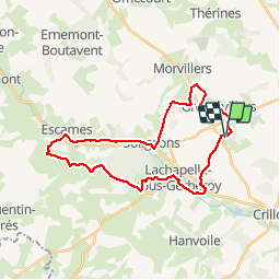
Randonnée Cheval de 27 km à découvrir à Hauts-de-France, Oise, Grémévillers. Cette randonnée est proposée par hippomobiles.
Description
Randonnée de printemps à l'occasion de la journée nationale de l'attelage de loisirs.
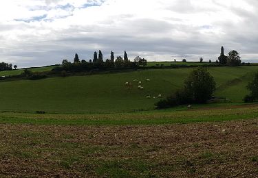
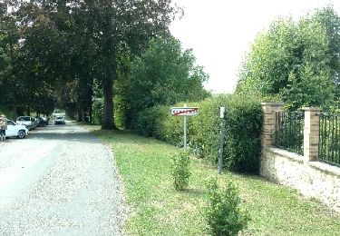
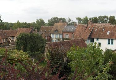
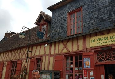
Cette promenade permet de découvrir de très beaux paysages avec en particulier la traversée de Gerberoy. Cette randonnée nécessite des chevaux entrainés compte tenu des dénivelés.
Localisation
Pays :
France
Région :
Hauts-de-France
Département/Province :
Oise
Commune :
Grémévillers
Localité :
Unknown
Départ:(Dec)
Départ:(UTM)
420429 ; 5489482 (31U) N.
Commentaires
Randonnées à proximité
![Randonnée Marche Hanvoile - 20200903-Gerberoy - Photo](https://media.geolcdn.com/t/375/260/ext.jpg?maxdim=2&url=https%3A%2F%2Fmedia.geolcdn.com%2Ff%2F5a05eb85-8439-4176-8f94-b0fe2d62e8c6.jpg)
![Marche Marche](https://static1.geolcdn.com/sitytour/trail-icons/101.png)
20200903-Gerberoy
Marche
Moyen
Hanvoile,
Hauts-de-France,
Oise,
France
![](/images/other/stat-length.png)
24 km | 29 km-effort
6h 59min
![](https://static1.geolcdn.com/siteimages/upload/files/16400158638029165_repeat_loop_refresh_sync_direction_icon.png)
Oui
![Randonnée Marche Gerberoy - gerberoy et songeons - Photo](https://media.geolcdn.com/t/375/260/ext.jpg?maxdim=2&url=https%3A%2F%2Fservices.sitytrail.com%2FGeolivesWS%2FDownloadMedia.ashx%3FTrailID%3D798824%26Media%3Dfix__20170730114547.jpg)
![Marche Marche](https://static1.geolcdn.com/sitytour/trail-icons/101.png)
gerberoy et songeons
Marche
Moyen
Gerberoy,
Hauts-de-France,
Oise,
France
![](/images/other/stat-length.png)
6,9 km | 9,1 km-effort
1h 46min
![](https://static1.geolcdn.com/siteimages/upload/files/16400158638029165_repeat_loop_refresh_sync_direction_icon.png)
Oui
![Randonnée Marche Songeons - gerberoy - Photo](https://media.geolcdn.com/t/375/260/ext.jpg?maxdim=2&url=https%3A%2F%2Fstatic1.geolcdn.com%2Fsiteimages%2Fupload%2Ffiles%2F1553511878bg_sport_marche.png)
![Marche Marche](https://static1.geolcdn.com/sitytour/trail-icons/101.png)
gerberoy
Marche
Moyen
(2)
Songeons,
Hauts-de-France,
Oise,
France
![](/images/other/stat-length.png)
12,9 km | 16,7 km-effort
Inconnu
![](https://static1.geolcdn.com/siteimages/upload/files/16400158638029165_repeat_loop_refresh_sync_direction_icon.png)
Oui
![Randonnée Marche Songeons - Circuit à la découverte de Gerberoy - Songeons - Photo](https://media.geolcdn.com/t/375/260/ext.jpg?maxdim=2&url=https%3A%2F%2Fservices.sitytrail.com%2FGeolivesWS%2FDownloadMedia.ashx%3FTrailID%3D110353%26Media%3D5805_6.jpg)
![Marche Marche](https://static1.geolcdn.com/sitytour/trail-icons/101.png)
Circuit à la découverte de Gerberoy - Songeons
Marche
Moyen
Songeons,
Hauts-de-France,
Oise,
France
![](/images/other/stat-length.png)
9,3 km | 11,9 km-effort
2h 15min
![](https://static1.geolcdn.com/siteimages/upload/files/16400158638029165_repeat_loop_refresh_sync_direction_icon.png)
Oui
![Randonnée Marche Gerberoy - Sortie Gerberoy 24/05/2018 - Photo](https://media.geolcdn.com/t/375/260/ext.jpg?maxdim=2&url=https%3A%2F%2Fservices.sitytrail.com%2FGeolivesWS%2FDownloadMedia.ashx%3FTrailID%3D979106%26Media%3Dfix__20180524120224.jpg)
![Marche Marche](https://static1.geolcdn.com/sitytour/trail-icons/101.png)
Sortie Gerberoy 24/05/2018
Marche
Facile
Gerberoy,
Hauts-de-France,
Oise,
France
![](/images/other/stat-length.png)
1,2 km | 1,4 km-effort
1h 42min
![](https://static1.geolcdn.com/siteimages/upload/files/16400158638029165_repeat_loop_refresh_sync_direction_icon.png)
Oui
![Randonnée A pied Gerberoy - gerberoy et les 2 lavoirs - Photo](https://media.geolcdn.com/t/375/260/ext.jpg?maxdim=2&url=https%3A%2F%2Fstatic1.geolcdn.com%2Fsiteimages%2Fupload%2Ffiles%2F1545311037marcheuse_200dpi.jpg)
![A pied A pied](https://static1.geolcdn.com/sitytour/trail-icons/100.png)
gerberoy et les 2 lavoirs
A pied
Facile
Gerberoy,
Hauts-de-France,
Oise,
France
![](/images/other/stat-length.png)
6,8 km | 8,7 km-effort
1h 58min
![](https://static1.geolcdn.com/siteimages/upload/files/16400158638029165_repeat_loop_refresh_sync_direction_icon.png)
Oui
![Randonnée A pied Gerberoy - gerberoy - Photo](https://media.geolcdn.com/t/375/260/ext.jpg?maxdim=2&url=https%3A%2F%2Fstatic1.geolcdn.com%2Fsiteimages%2Fupload%2Ffiles%2F1545311037marcheuse_200dpi.jpg)
![A pied A pied](https://static1.geolcdn.com/sitytour/trail-icons/100.png)
![Randonnée Marche Songeons - Songeons - Au nom de la rose - Photo](https://media.geolcdn.com/t/375/260/ext.jpg?maxdim=2&url=https%3A%2F%2Fstatic1.geolcdn.com%2Fsiteimages%2Fupload%2Ffiles%2F1553511878bg_sport_marche.png)
![Marche Marche](https://static1.geolcdn.com/sitytour/trail-icons/101.png)
Songeons - Au nom de la rose
Marche
Très difficile
Songeons,
Hauts-de-France,
Oise,
France
![](/images/other/stat-length.png)
16,8 km | 22 km-effort
4h 55min
![](https://static1.geolcdn.com/siteimages/upload/files/16400158638029165_repeat_loop_refresh_sync_direction_icon.png)
Oui
![Randonnée Marche Gerberoy - Gerberoy vers Songeons et retour - Photo](https://media.geolcdn.com/t/375/260/ext.jpg?maxdim=2&url=https%3A%2F%2Fstatic1.geolcdn.com%2Fsiteimages%2Fupload%2Ffiles%2F1553511878bg_sport_marche.png)
![Marche Marche](https://static1.geolcdn.com/sitytour/trail-icons/101.png)
Gerberoy vers Songeons et retour
Marche
Très facile
Gerberoy,
Hauts-de-France,
Oise,
France
![](/images/other/stat-length.png)
7 km | 8,7 km-effort
1h 50min
![](https://static1.geolcdn.com/siteimages/upload/files/16400158638029165_repeat_loop_refresh_sync_direction_icon.png)
Non