Randonnée Marche Savonnières - Savonnières - Photo
 LEMENIO
LEMENIO

Utilisateur

© OpenStreetMap contributors
Longueur
Longueur
11,8 km
Altitude max
Altitude max
89 m
Dénivelé positif
Dénivelé positif
135 m
Km-Effort
Km-Effort  
13,6 km
Altitude min
Altitude min
40 m
Dénivelé négatif
Dénivelé négatif
134 m
Boucle
Boucle
Oui
Date de création :
2014-12-10 00:00:00.0
Dernière modification :
2014-12-10 00:00:00.0

(0 Avis)

Marche
Marche
3h00
Difficulté : Moyen

Scannez ce code QR pour ouvrir la randonnée dans l'application SityTrail

Application GPS de randonnée GRATUITE

Logo SityTrail SityTrail

IGN / Instituts géographiques

Télécharger SityTrail sur l'App Store Télécharger SityTrail sur Google Play

Logo SityTrail SityTrail World

Le monde est à vous

Télécharger SityTrail sur l'App Store Télécharger SityTrail sur Google Play Télécharger SityTrail sur Huawei AppGallery

À propos

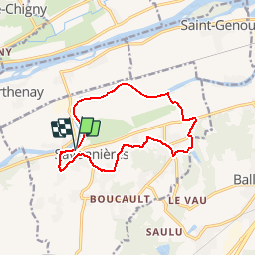
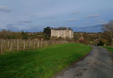
Randonnée Marche de 11,8 km à découvrir à Centre-Val de Loire, Indre-et-Loire, Savonnières. Cette randonnée est proposée par LEMENIO.

Description

Départ place des charmilles. La fin de parcours peut être raccourcie de 2.5 Km en filant tout droit jusqu'au bas de la rue du paradis  ( entrée du bourg). Sinon tourner à gauche pour faire la boucle finale (fin de descente un peu raide).

Profil altimétrique

Localisation

Pays :
France
Région :
Centre-Val de Loire
Département/Province :
Indre-et-Loire
Commune :
Savonnières
Localité :
Unknown
Départ:(Dec)
Départ:(UTM)
314747 ; 5246792 (31T) N.

Randonnées à proximité

Randonnée Marche Villandry - Villandry - boucle bord du Cher puis GR3 - 4.9km 60m 1h15 - 2015 05 24 - Photo
Marche
GUIDE
Orcal37

Marche

Facile
(1)
Villandry, Centre-Val de Loire, Indre-et-Loire, France
4,9 km | 5,7 km-effort
1h 15min
Oui
Randonnée Marche Savonnières - Savonnières - Zig zag Villandry - 20.7km 260m 4h25 (40mn) - 2024 06 02 - Photo
Marche
GUIDE
Orcal37

Marche

Facile
Savonnières, Centre-Val de Loire, Indre-et-Loire, France
21 km | 24 km-effort
4h 25min
Oui
Randonnée Marche Ballan-Miré - Ballan-Miré - Parking des Châtaigniers - 8.4km 125m 1h50 - 2024 03 06 - Photo
Marche
GUIDE
Orcal37

Marche

Moyen
Ballan-Miré, Centre-Val de Loire, Indre-et-Loire, France
8,4 km | 10,1 km-effort
1h 50min
Oui
Randonnée Marche Saint-Étienne-de-Chigny - Saint-Étienne-de-Chigny - le Vieux Bourg - Luynes - 15.8km 285m 3h30 - 2024 02 28 - Photo
Marche
GUIDE
Orcal37

Marche

Moyen
Saint-Étienne-de-Chigny, Centre-Val de Loire, Indre-et-Loire, France
15,8 km | 19,6 km-effort
3h 30min
Oui
Randonnée Marche Saint-Étienne-de-Chigny - Saint-Étienne-de-Chigny - la Pile de Cinq-Mars-la-Pile - 14.2km 215m 3h15 - 2024 02 17 - Photo
Marche
GUIDE
Orcal37

Marche

Moyen
Saint-Étienne-de-Chigny, Centre-Val de Loire, Indre-et-Loire, France
14,5 km | 17,2 km-effort
3h 15min
Oui
Randonnée Marche Savonnières - Savonnières - les Fontaines GR3 et PRs - 20.1km 190m 4h40 - 2022 05 12 - Photo
Marche
GUIDE
Orcal37

Marche

Facile
Savonnières, Centre-Val de Loire, Indre-et-Loire, France
20 km | 23 km-effort
4h 40min
Oui
Randonnée Marche Berthenay - Berthenay - Sentier des deux Eaux - 16.3km 65m 4h00 - 2022 05 08 - Photo
Marche
GUIDE
Orcal37

Marche

Facile
Berthenay, Centre-Val de Loire, Indre-et-Loire, France
16,3 km | 17,2 km-effort
4h 0min
Oui
Randonnée Marche Saint-Étienne-de-Chigny - Saint-Étienne-de-Chigny - Pont de Bresme - 23.4km 275m 4h45 (25mn) - 2021 07 08 - Photo
Marche
GUIDE
Orcal37

Marche

Facile
Saint-Étienne-de-Chigny, Centre-Val de Loire, Indre-et-Loire, France
23 km | 27 km-effort
4h 45min
Oui
Randonnée Marche Artannes-sur-Indre - Artannes-sur-Indre - la Mânerie - GRP PR - 14.5km 100m 3h00 - 2021 06 05 - Photo
Marche
GUIDE
Orcal37

Marche

Facile
Artannes-sur-Indre, Centre-Val de Loire, Indre-et-Loire, France
14,5 km | 15,8 km-effort
3h 0min
Oui


Fermer
Mes abonnements