![](/images/other/stat-length.png)
![Randonnée Cyclotourisme Mauléon-Licharre - Mauléon Licharre - Le tour de Soule - Photo](https://media.geolcdn.com/t/1900/400/ext.pjpeg?maxdim=2&url=https%3A%2F%2Fstatic1.geolcdn.com%2Fsiteimages%2Fupload%2Ffiles%2F1524743154velo.jpg)
Mauléon Licharre - Le tour de Soule
potofe
Utilisateur
![Longueur](/images/other/stat-length.png)
Longueur
84 km
![Altitude max](https://static1.geolcdn.com/siteimages/upload/files/1508320355ic_sort_altitude_max_24dp.png)
Altitude max
433 m
![Dénivelé positif](https://static1.geolcdn.com/siteimages/upload/files/1508320355ic_sort_den_pos_24dp.png)
Dénivelé positif
1469 m
![Km-Effort](/images/other/stat-length.png)
Km-Effort
104 km
![Altitude min](https://static1.geolcdn.com/siteimages/upload/files/1508320355ic_sort_altitude_min_24dp.png)
Altitude min
128 m
![Dénivelé négatif](https://static1.geolcdn.com/siteimages/upload/files/1508320355ic_sort_den_neg_24dp.png)
Dénivelé négatif
1469 m
![Boucle](https://static1.geolcdn.com/siteimages/upload/files/16400158638029165_repeat_loop_refresh_sync_direction_icon.png)
Boucle
Oui
Date de création :
2018-09-07 19:25:00.262
Dernière modification :
2018-10-31 17:45:30.051
![Cyclotourisme](https://static1.geolcdn.com/sitytour/trail-icons/204.png)
--
Difficulté : Moyen
![Scannez ce code QR pour ouvrir la randonnée dans l'application SityTrail](https://capi.geolives.com/qq0zvz2zws4bq2lad0pu/sitytour/trails/120244/qr.png?size=200)
Application GPS de randonnée GRATUITE
À propos
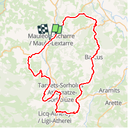
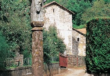
Randonnée Cyclotourisme de 84 km à découvrir à Nouvelle-Aquitaine, Pyrénées-Atlantiques, Mauléon-Licharre. Cette randonnée est proposée par potofe.
Description
Vélo 64
Rando N° 17
Parcours une ou deux journées, à prendre avec sérieux, pour cyclotouriste chevronné (entrainement de 3000 à 4000 km). Attention, au col de la Serre. Petirs braquets recommandés (28x24 ou 28x26 par exemple).
Localisation
Pays :
France
Région :
Nouvelle-Aquitaine
Département/Province :
Pyrénées-Atlantiques
Commune :
Mauléon-Licharre
Localité :
Unknown
Départ:(Dec)
Départ:(UTM)
671270 ; 4787495 (30T) N.
Commentaires
Randonnées à proximité
![Randonnée Marche Ordiarp - ORDIARP la chapelle st Gregoire G3 4082977 - Photo](https://media.geolcdn.com/t/375/260/69f9a433-761a-4dab-85bf-268ab4f86849.jpg&format=jpg&maxdim=2)
![Marche Marche](https://static1.geolcdn.com/sitytour/trail-icons/101.png)
ORDIARP la chapelle st Gregoire G3 4082977
Marche
Difficile
Ordiarp,
Nouvelle-Aquitaine,
Pyrénées-Atlantiques,
France
![](/images/other/stat-length.png)
11,9 km | 17 km-effort
3h 28min
![](https://static1.geolcdn.com/siteimages/upload/files/16400158638029165_repeat_loop_refresh_sync_direction_icon.png)
Oui
![Randonnée Marche Ordiarp - ORDIARP le Kaskaborro G4 4079186 - Photo](https://media.geolcdn.com/t/375/260/71036ec1-6837-455a-bad4-847d1d3f0ecb.jpg&format=jpg&maxdim=2)
![Marche Marche](https://static1.geolcdn.com/sitytour/trail-icons/101.png)
ORDIARP le Kaskaborro G4 4079186
Marche
Difficile
Ordiarp,
Nouvelle-Aquitaine,
Pyrénées-Atlantiques,
France
![](/images/other/stat-length.png)
10,1 km | 13,4 km-effort
3h 6min
![](https://static1.geolcdn.com/siteimages/upload/files/16400158638029165_repeat_loop_refresh_sync_direction_icon.png)
Oui
![Randonnée Marche Mauléon-Licharre - 2023 10 13 CHEMIN du PIÉMONT PYRÉNÉEN - 21ème étape : Mauléon-Lichare - Ordiap - Col de Napha - Saint-Just - Col de Gamia -Saint-Jean-le-Vieux - Saint-Jean-Pied-De-Port - Photo](https://media.geolcdn.com/t/375/260/673abf07-cf35-4d07-9936-873e2cf985c3.jpg&format=jpg&maxdim=2)
![Marche Marche](https://static1.geolcdn.com/sitytour/trail-icons/101.png)
2023 10 13 CHEMIN du PIÉMONT PYRÉNÉEN - 21ème étape : Mauléon-Lichare - Ordia...
Marche
Très difficile
Mauléon-Licharre,
Nouvelle-Aquitaine,
Pyrénées-Atlantiques,
France
![](/images/other/stat-length.png)
42 km | 55 km-effort
7h 51min
![](https://static1.geolcdn.com/siteimages/upload/files/16400158638029165_repeat_loop_refresh_sync_direction_icon.png)
Non
![Randonnée Marche Mauléon-Licharre - Chemin du Piémont Pyrénéen - De Mauléon Licharre à Saint Just Ibarre - Photo](https://media.geolcdn.com/t/375/260/ext.jpg?maxdim=2&url=https%3A%2F%2Fservices.sitytrail.com%2FGeolivesWS%2FDownloadMedia.ashx%3FTrailID%3D111320%26Media%3D6993_1.jpg)
![Marche Marche](https://static1.geolcdn.com/sitytour/trail-icons/101.png)
Chemin du Piémont Pyrénéen - De Mauléon Licharre à Saint Just Ibarre
Marche
Difficile
Mauléon-Licharre,
Nouvelle-Aquitaine,
Pyrénées-Atlantiques,
France
![](/images/other/stat-length.png)
22 km | 33 km-effort
6h 0min
![](https://static1.geolcdn.com/siteimages/upload/files/16400158638029165_repeat_loop_refresh_sync_direction_icon.png)
Non
![Randonnée Marche Ordiarp - fait - Photo](https://media.geolcdn.com/t/375/260/dc283403-16a2-429c-8cc1-dfe07b9af167.jpg&format=jpg&maxdim=2)
![Marche Marche](https://static1.geolcdn.com/sitytour/trail-icons/101.png)
fait
Marche
Difficile
Ordiarp,
Nouvelle-Aquitaine,
Pyrénées-Atlantiques,
France
![](/images/other/stat-length.png)
10,3 km | 13,6 km-effort
5h 49min
![](https://static1.geolcdn.com/siteimages/upload/files/16400158638029165_repeat_loop_refresh_sync_direction_icon.png)
Oui
![Randonnée Marche Mauléon-Licharre - Mauléon-Licharre_St Just-Ibarre - Photo](https://media.geolcdn.com/t/375/260/ext.jpg?maxdim=2&url=https%3A%2F%2Fstatic1.geolcdn.com%2Fsiteimages%2Fupload%2Ffiles%2F1553511878bg_sport_marche.png)
![Marche Marche](https://static1.geolcdn.com/sitytour/trail-icons/101.png)
Mauléon-Licharre_St Just-Ibarre
Marche
Difficile
Mauléon-Licharre,
Nouvelle-Aquitaine,
Pyrénées-Atlantiques,
France
![](/images/other/stat-length.png)
20 km | 27 km-effort
5h 40min
![](https://static1.geolcdn.com/siteimages/upload/files/16400158638029165_repeat_loop_refresh_sync_direction_icon.png)
Non
![Randonnée Cheval Ordiarp - Juni 10 gedeeltelijk grote weg redelijke klim, verder kleine weg met pittige klimoen - Photo](https://media.geolcdn.com/t/375/260/ext.jpg?maxdim=2&url=https%3A%2F%2Fstatic1.geolcdn.com%2Fsiteimages%2Fupload%2Ffiles%2F1524743154cheval.jpg)
![Cheval Cheval](https://static1.geolcdn.com/sitytour/trail-icons/300.png)
Juni 10 gedeeltelijk grote weg redelijke klim, verder kleine weg met pittige ...
Cheval
Très facile
Ordiarp,
Nouvelle-Aquitaine,
Pyrénées-Atlantiques,
France
![](/images/other/stat-length.png)
36 km | 48 km-effort
Inconnu
![](https://static1.geolcdn.com/siteimages/upload/files/16400158638029165_repeat_loop_refresh_sync_direction_icon.png)
Non
![Randonnée A pied Mauléon-Licharre - Compostelle 10/24 Mauléon St-Just Ibarre 07 - Photo](https://media.geolcdn.com/t/375/260/ext.jpg?maxdim=2&url=https%3A%2F%2Fstatic1.geolcdn.com%2Fsiteimages%2Fupload%2Ffiles%2F1545311037marcheuse_200dpi.jpg)
![A pied A pied](https://static1.geolcdn.com/sitytour/trail-icons/100.png)
Compostelle 10/24 Mauléon St-Just Ibarre 07
A pied
Difficile
Mauléon-Licharre,
Nouvelle-Aquitaine,
Pyrénées-Atlantiques,
France
![](/images/other/stat-length.png)
23 km | 34 km-effort
7h 38min
![](https://static1.geolcdn.com/siteimages/upload/files/16400158638029165_repeat_loop_refresh_sync_direction_icon.png)
Non
![Randonnée Marche Mauléon-Licharre - 22. Mauleon - St Just Ibarre variante - Photo](https://media.geolcdn.com/t/375/260/ext.jpg?maxdim=2&url=https%3A%2F%2Fstatic1.geolcdn.com%2Fsiteimages%2Fupload%2Ffiles%2F1553511878bg_sport_marche.png)
![Marche Marche](https://static1.geolcdn.com/sitytour/trail-icons/101.png)
22. Mauleon - St Just Ibarre variante
Marche
Très difficile
Mauléon-Licharre,
Nouvelle-Aquitaine,
Pyrénées-Atlantiques,
France
![](/images/other/stat-length.png)
25 km | 36 km-effort
8h 15min
![](https://static1.geolcdn.com/siteimages/upload/files/16400158638029165_repeat_loop_refresh_sync_direction_icon.png)
Non