![](/images/other/stat-length.png)
![Randonnée Marche Vernou-sur-Brenne - Vernou-sur-Brenne - Photo](https://media.geolcdn.com/t/1900/400/ext.pjpeg?maxdim=2&url=https%3A%2F%2Fstatic1.geolcdn.com%2Fsiteimages%2Fupload%2Ffiles%2F1553511878bg_sport_marche.png)
Vernou-sur-Brenne
LEMENIO
Utilisateur
![Longueur](/images/other/stat-length.png)
Longueur
13,3 km
![Altitude max](https://static1.geolcdn.com/siteimages/upload/files/1508320355ic_sort_altitude_max_24dp.png)
Altitude max
117 m
![Dénivelé positif](https://static1.geolcdn.com/siteimages/upload/files/1508320355ic_sort_den_pos_24dp.png)
Dénivelé positif
174 m
![Km-Effort](/images/other/stat-length.png)
Km-Effort
15,6 km
![Altitude min](https://static1.geolcdn.com/siteimages/upload/files/1508320355ic_sort_altitude_min_24dp.png)
Altitude min
52 m
![Dénivelé négatif](https://static1.geolcdn.com/siteimages/upload/files/1508320355ic_sort_den_neg_24dp.png)
Dénivelé négatif
174 m
![Boucle](https://static1.geolcdn.com/siteimages/upload/files/16400158638029165_repeat_loop_refresh_sync_direction_icon.png)
Boucle
Oui
Date de création :
2014-12-10 00:00:00.0
Dernière modification :
2014-12-10 00:00:00.0
![Marche](https://static1.geolcdn.com/sitytour/trail-icons/101.png)
3h01
Difficulté : Moyen
![Scannez ce code QR pour ouvrir la randonnée dans l'application SityTrail](https://capi.geolives.com/qq0zvz2zws4bq2lad0pu/sitytour/trails/119318/qr.png?size=200)
Application GPS de randonnée GRATUITE
À propos
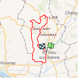
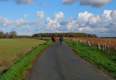
Randonnée Marche de 13,3 km à découvrir à Centre-Val de Loire, Indre-et-Loire, Vernou-sur-Brenne. Cette randonnée est proposée par LEMENIO.
Description
Départ à partir de la place située derrière la mairie. Le début de chemin est situé sur le passage de l'ancienne voie ferrée.
Localisation
Pays :
France
Région :
Centre-Val de Loire
Département/Province :
Indre-et-Loire
Commune :
Vernou-sur-Brenne
Localité :
Unknown
Départ:(Dec)
Départ:(UTM)
337369 ; 5254277 (31T) N.
Commentaires
Randonnées à proximité
![Randonnée Marche Vernou-sur-Brenne - Vernou-sur-Brenne la Coudraie - Zig Zag Vaubrault Noizay - 27.1km 385m 5h55 (55mn) - 2024 11 03 - Photo](https://media.geolcdn.com/t/375/260/9c945cd3-c4f0-44b2-b00c-aa0430042429.jpg&format=jpg&maxdim=2)
![Marche Marche](https://static1.geolcdn.com/sitytour/trail-icons/101.png)
Vernou-sur-Brenne la Coudraie - Zig Zag Vaubrault Noizay - 27.1km 385m 5h55 (...
Marche
Facile
Vernou-sur-Brenne,
Centre-Val de Loire,
Indre-et-Loire,
France
![](/images/other/stat-length.png)
27 km | 32 km-effort
5h 55min
![](https://static1.geolcdn.com/siteimages/upload/files/16400158638029165_repeat_loop_refresh_sync_direction_icon.png)
Oui
![Randonnée Marche Chançay - Chançay - Zig zag Reugny GR655ouest - 20.3km 380m 4h40 (40mn) - 2024 04 28 - Photo](https://media.geolcdn.com/t/375/260/efedd979-b27d-4d96-b85e-cafd7eb7449e.jpg&format=jpg&maxdim=2)
![Marche Marche](https://static1.geolcdn.com/sitytour/trail-icons/101.png)
Chançay - Zig zag Reugny GR655ouest - 20.3km 380m 4h40 (40mn) - 2024 04 28
Marche
Moyen
Chançay,
Centre-Val de Loire,
Indre-et-Loire,
France
![](/images/other/stat-length.png)
20 km | 25 km-effort
4h 40min
![](https://static1.geolcdn.com/siteimages/upload/files/16400158638029165_repeat_loop_refresh_sync_direction_icon.png)
Oui
![Randonnée Marche Noizay - Noizay - Zig zag autour des Coteaux à l'est de Noizay - 21.3km 370m 5h00 (40mn) - 2024 03 20 - Photo](https://media.geolcdn.com/t/375/260/6f5cee46-8120-45a7-a457-5ad832f22807.jpg&format=jpg&maxdim=2)
![Marche Marche](https://static1.geolcdn.com/sitytour/trail-icons/101.png)
Noizay - Zig zag autour des Coteaux à l'est de Noizay - 21.3km 370m 5h00 (40m...
Marche
Moyen
Noizay,
Centre-Val de Loire,
Indre-et-Loire,
France
![](/images/other/stat-length.png)
21 km | 26 km-effort
5h 0min
![](https://static1.geolcdn.com/siteimages/upload/files/16400158638029165_repeat_loop_refresh_sync_direction_icon.png)
Oui
![Randonnée Marche Chançay - Chançay - Vaux et le Bois de Chançay - 8.7km 150m 2h05 - 2023 09 19 - Photo](https://media.geolcdn.com/t/375/260/786bee5a-6029-4ac7-a35b-1f5de9be2a5c.jpg&format=jpg&maxdim=2)
![Marche Marche](https://static1.geolcdn.com/sitytour/trail-icons/101.png)
Chançay - Vaux et le Bois de Chançay - 8.7km 150m 2h05 - 2023 09 19
Marche
Facile
Chançay,
Centre-Val de Loire,
Indre-et-Loire,
France
![](/images/other/stat-length.png)
8,7 km | 10,7 km-effort
2h 5min
![](https://static1.geolcdn.com/siteimages/upload/files/16400158638029165_repeat_loop_refresh_sync_direction_icon.png)
Oui
![Randonnée Marche Vouvray - Vouvray - PR balisé en bleu - 15.1km 125m 3h30 - 2023 06 28 - Photo](https://media.geolcdn.com/t/375/260/60d19163-b23a-4217-bba8-93e697ea97cd.jpg&format=jpg&maxdim=2)
![Marche Marche](https://static1.geolcdn.com/sitytour/trail-icons/101.png)
Vouvray - PR balisé en bleu - 15.1km 125m 3h30 - 2023 06 28
Marche
Facile
Vouvray,
Centre-Val de Loire,
Indre-et-Loire,
France
![](/images/other/stat-length.png)
15,1 km | 16,8 km-effort
3h 30min
![](https://static1.geolcdn.com/siteimages/upload/files/16400158638029165_repeat_loop_refresh_sync_direction_icon.png)
Oui
![Randonnée Marche Vernou-sur-Brenne - Vernou-sur-Brenne - Variante Sentier Vignes et Patrimoine - 10.9km 140m 2h30 (25mn) - 2023 06 28 - Photo](https://media.geolcdn.com/t/375/260/1dfb41e2-d3bf-47c9-be6e-516142895db1.jpg&format=jpg&maxdim=2)
![Marche Marche](https://static1.geolcdn.com/sitytour/trail-icons/101.png)
Vernou-sur-Brenne - Variante Sentier Vignes et Patrimoine - 10.9km 140m 2h30 ...
Marche
Facile
Vernou-sur-Brenne,
Centre-Val de Loire,
Indre-et-Loire,
France
![](/images/other/stat-length.png)
10,9 km | 12,8 km-effort
2h 30min
![](https://static1.geolcdn.com/siteimages/upload/files/16400158638029165_repeat_loop_refresh_sync_direction_icon.png)
Oui
![Randonnée Cyclotourisme Montlouis-sur-Loire - De Montlouis sur Loire à Villandry - Photo](https://media.geolcdn.com/t/375/260/06e7a589-0b86-4225-a7bb-150a85f87cea.jpg&format=jpg&maxdim=2)
![Cyclotourisme Cyclotourisme](https://static1.geolcdn.com/sitytour/trail-icons/204.png)
De Montlouis sur Loire à Villandry
Cyclotourisme
Moyen
Montlouis-sur-Loire,
Centre-Val de Loire,
Indre-et-Loire,
France
![](/images/other/stat-length.png)
78 km | 85 km-effort
5h 18min
![](https://static1.geolcdn.com/siteimages/upload/files/16400158638029165_repeat_loop_refresh_sync_direction_icon.png)
Non
![Randonnée Marche Noizay - la Bousserie - Noizay - 14km 100m 3h00 - 2023 02 12 - Photo](https://media.geolcdn.com/t/375/260/e82473dd-70b3-426f-8e44-9d257c621d06.jpg&format=jpg&maxdim=2)
![Marche Marche](https://static1.geolcdn.com/sitytour/trail-icons/101.png)
la Bousserie - Noizay - 14km 100m 3h00 - 2023 02 12
Marche
Très facile
Noizay,
Centre-Val de Loire,
Indre-et-Loire,
France
![](/images/other/stat-length.png)
14 km | 15,4 km-effort
3h 0min
![](https://static1.geolcdn.com/siteimages/upload/files/16400158638029165_repeat_loop_refresh_sync_direction_icon.png)
Oui
![Randonnée Marche Noizay - Noizay - Carcou Vernou via PRs Chançay - 24.7km 290m 5h20 (30mn) - 2022 11 19 - Photo](https://media.geolcdn.com/t/375/260/2672b0f2-49c2-42ff-9714-49118cac5701.jpg&format=jpg&maxdim=2)
![Marche Marche](https://static1.geolcdn.com/sitytour/trail-icons/101.png)
Noizay - Carcou Vernou via PRs Chançay - 24.7km 290m 5h20 (30mn) - 2022 11 19
Marche
Facile
Noizay,
Centre-Val de Loire,
Indre-et-Loire,
France
![](/images/other/stat-length.png)
25 km | 29 km-effort
5h 20min
![](https://static1.geolcdn.com/siteimages/upload/files/16400158638029165_repeat_loop_refresh_sync_direction_icon.png)
Oui