Randonnée Marche Saint-Antonin-sur-Bayon - 13 Ste Victoire - Tracé Jaune - Photo
 phidge
phidge

Utilisateur

© OpenStreetMap contributors
Longueur
Longueur
7,4 km
Altitude max
Altitude max
882 m
Dénivelé positif
Dénivelé positif
598 m
Km-Effort
Km-Effort  
15,4 km
Altitude min
Altitude min
306 m
Dénivelé négatif
Dénivelé négatif
599 m
Boucle
Boucle
Oui
Date de création :
2019-01-20 16:38:28.742
Dernière modification :
2019-01-20 16:38:28.778

(0 Avis)

Marche
Marche
5h43
Difficulté : Très difficile

Scannez ce code QR pour ouvrir la randonnée dans l'application SityTrail

Application GPS de randonnée GRATUITE

Logo SityTrail SityTrail

IGN / Instituts géographiques

Télécharger SityTrail sur l'App Store Télécharger SityTrail sur Google Play

Logo SityTrail SityTrail World

Le monde est à vous

Télécharger SityTrail sur l'App Store Télécharger SityTrail sur Google Play Télécharger SityTrail sur Huawei AppGallery

À propos

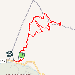
Randonnée Marche de 7,4 km à découvrir à Provence-Alpes-Côte d'Azur, Bouches-du-Rhône, Saint-Antonin-sur-Bayon. Cette randonnée est proposée par phidge.

Description

P3 T3
 Chaine qui peut être évitée sur jaune pointillé.
 Retour par la cheminée, au dessus du refuge Cézanne.
 Prendre une corde et sangle pour faire un baudrier.

Profil altimétrique

Localisation

Pays :
France
Région :
Provence-Alpes-Côte d'Azur
Département/Province :
Bouches-du-Rhône
Commune :
Saint-Antonin-sur-Bayon
Localité :
Unknown
Départ:(Dec)
Départ:(UTM)
707363 ; 4822162 (31T) N.

Randonnées à proximité

Randonnée Marche Saint-Antonin-sur-Bayon - Ste Victoire - Le Garagaï - Photo
Marche
ETMU5496

Marche

Difficile
(1)
Saint-Antonin-sur-Bayon, Provence-Alpes-Côte d'Azur, Bouches-du-Rhône, France
15,8 km | 28 km-effort
4h 36min
Oui
Randonnée Marche Saint-Marc-Jaumegarde - Barrages Zola-Bimont - Photo
Marche
Berpav

Marche

Moyen
(2)
Saint-Marc-Jaumegarde, Provence-Alpes-Côte d'Azur, Bouches-du-Rhône, France
8 km | 11 km-effort
2h 30min
Oui
Randonnée Marche Vauvenargues - Le Signal, Montagne Sainte-Victoire - Photo
Marche
tracegps

Marche

Moyen
(2)
Vauvenargues, Provence-Alpes-Côte d'Azur, Bouches-du-Rhône, France
15 km | 25 km-effort
6h 19min
Oui
Randonnée Marche Saint-Marc-Jaumegarde - La Croix de Provence depuis le barrage de Bimont - Photo
Marche
tracegps

Marche

Difficile
(1)
Saint-Marc-Jaumegarde, Provence-Alpes-Côte d'Azur, Bouches-du-Rhône, France
13,9 km | 24 km-effort
4h 45min
Oui
Randonnée Marche Saint-Antonin-sur-Bayon - 2023-02-10 Sainte Victoire Bau des Vespres - Photo
Marche
GUIDE
Kargil

Marche

Difficile
Saint-Antonin-sur-Bayon, Provence-Alpes-Côte d'Azur, Bouches-du-Rhône, France
10 km | 18,8 km-effort
3h 30min
Oui
Randonnée A pied Vauvenargues - Sentier des Venturiers - Photo
A pied
GUIDE+

A pied

Facile
Vauvenargues, Provence-Alpes-Côte d'Azur, Bouches-du-Rhône, France
5 km | 10,5 km-effort
2h 23min
Non
Randonnée A pied Beaurecueil - Sentier Imoucha - Photo
A pied
GUIDE+

A pied

Facile
Beaurecueil, Provence-Alpes-Côte d'Azur, Bouches-du-Rhône, France
4,4 km | 10,1 km-effort
2h 17min
Non
Randonnée Marche Saint-Antonin-sur-Bayon - le Garagai, signal  - Photo
Marche
GUIDE
nadd73

Marche

Difficile
Saint-Antonin-sur-Bayon, Provence-Alpes-Côte d'Azur, Bouches-du-Rhône, France
6,8 km | 14,1 km-effort
3h 38min
Oui
Randonnée Marche Saint-Antonin-sur-Bayon - la croix de Provence - Photo
Marche
GUIDE
nadd73

Marche

Difficile
Saint-Antonin-sur-Bayon, Provence-Alpes-Côte d'Azur, Bouches-du-Rhône, France
6,6 km | 14,7 km-effort
5h 11min
Oui


Fermer
Mes abonnements