![](/images/other/stat-length.png)
![Randonnée Marche Bouquelon - Le phare de la Roque - Bouquelon - Photo](https://media.geolcdn.com/t/1900/400/ext.pjpeg?maxdim=2&url=https%3A%2F%2Fservices.sitytrail.com%2FGeolivesWS%2FDownloadMedia.ashx%3FTrailID%3D118767%26Media%3D12964_1.jpg)
Le phare de la Roque - Bouquelon
tracegps
Utilisateur
![Longueur](/images/other/stat-length.png)
Longueur
19,4 km
![Altitude max](https://static1.geolcdn.com/siteimages/upload/files/1508320355ic_sort_altitude_max_24dp.png)
Altitude max
120 m
![Dénivelé positif](https://static1.geolcdn.com/siteimages/upload/files/1508320355ic_sort_den_pos_24dp.png)
Dénivelé positif
350 m
![Km-Effort](/images/other/stat-length.png)
Km-Effort
24 km
![Altitude min](https://static1.geolcdn.com/siteimages/upload/files/1508320355ic_sort_altitude_min_24dp.png)
Altitude min
1 m
![Dénivelé négatif](https://static1.geolcdn.com/siteimages/upload/files/1508320355ic_sort_den_neg_24dp.png)
Dénivelé négatif
350 m
![Boucle](https://static1.geolcdn.com/siteimages/upload/files/16400158638029165_repeat_loop_refresh_sync_direction_icon.png)
Boucle
Oui
Date de création :
2014-12-10 00:00:00.0
Dernière modification :
2014-12-10 00:00:00.0
![Marche](https://static1.geolcdn.com/sitytour/trail-icons/101.png)
4h00
Difficulté : Moyen
![Scannez ce code QR pour ouvrir la randonnée dans l'application SityTrail](https://capi.geolives.com/qq0zvz2zws4bq2lad0pu/sitytour/trails/118767/qr.png?size=200)
Application GPS de randonnée GRATUITE
À propos
Randonnée Marche de 19,4 km à découvrir à Normandie, Eure, Bouquelon. Cette randonnée est proposée par tracegps.
Description
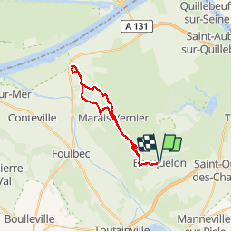
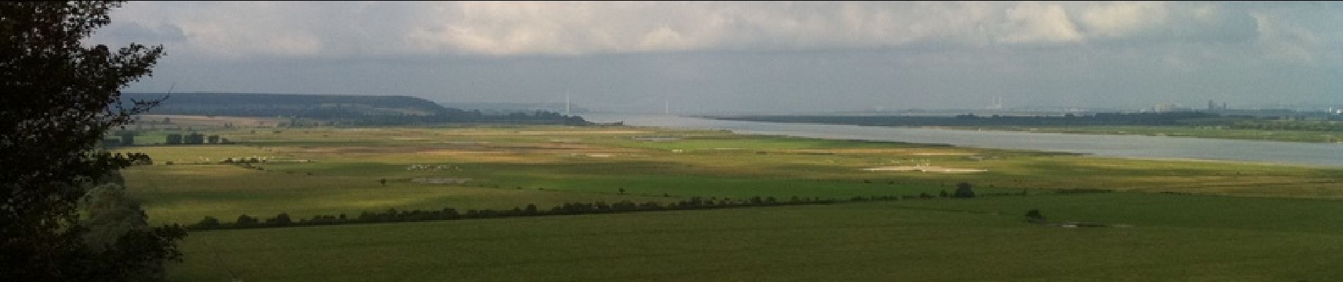
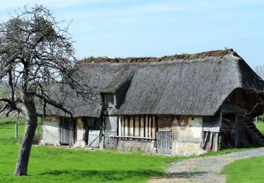
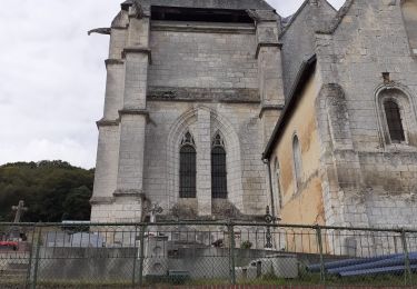
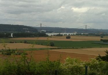
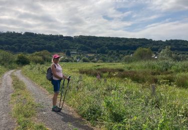
Balade dans le Marais-Vernier jusqu'au Phare de la Roque. Beaucoup d'asphalte, mais ce sont de petites routes de campagne où ne l'on croise guère que quelques tracteurs.
Localisation
Pays :
France
Région :
Normandie
Département/Province :
Eure
Commune :
Bouquelon
Localité :
Unknown
Départ:(Dec)
Départ:(UTM)
317911 ; 5474507 (31U) N.
Commentaires
Randonnées à proximité
![Randonnée Marche Marais-Vernier - 076-141- le Marais-vernier-10km - Photo](https://media.geolcdn.com/t/375/260/b613f315-8627-4fd7-a202-639fbd00f8cd.jpg&format=jpg&maxdim=2)
![Marche Marche](https://static1.geolcdn.com/sitytour/trail-icons/101.png)
076-141- le Marais-vernier-10km
Marche
Difficile
(1)
Marais-Vernier,
Normandie,
Eure,
France
![](/images/other/stat-length.png)
10,8 km | 13,8 km-effort
3h 7min
![](https://static1.geolcdn.com/siteimages/upload/files/16400158638029165_repeat_loop_refresh_sync_direction_icon.png)
Oui
![Randonnée A pied Sainte-Opportune-la-Mare - Chemin pédestre de l'Allée des Granges - Photo](https://media.geolcdn.com/t/375/260/7933c4e8-7afb-4170-943c-36ad14b0db16.jpeg&format=jpg&maxdim=2)
![A pied A pied](https://static1.geolcdn.com/sitytour/trail-icons/100.png)
Chemin pédestre de l'Allée des Granges
A pied
Facile
Sainte-Opportune-la-Mare,
Normandie,
Eure,
France
![](/images/other/stat-length.png)
6,4 km | 8,1 km-effort
1h 49min
![](https://static1.geolcdn.com/siteimages/upload/files/16400158638029165_repeat_loop_refresh_sync_direction_icon.png)
Oui
![Randonnée Marche Bouquelon - Boucle de Bouquelon V2 variante - Photo](https://media.geolcdn.com/t/375/260/ext.jpg?maxdim=2&url=https%3A%2F%2Fstatic1.geolcdn.com%2Fsiteimages%2Fupload%2Ffiles%2F1553511878bg_sport_marche.png)
![Marche Marche](https://static1.geolcdn.com/sitytour/trail-icons/101.png)
Boucle de Bouquelon V2 variante
Marche
Moyen
(1)
Bouquelon,
Normandie,
Eure,
France
![](/images/other/stat-length.png)
9,1 km | 11,1 km-effort
2h 31min
![](https://static1.geolcdn.com/siteimages/upload/files/16400158638029165_repeat_loop_refresh_sync_direction_icon.png)
Oui
![Randonnée Marche Bouquelon - Boucle de Bouquelon V1 - Photo](https://media.geolcdn.com/t/375/260/ext.jpg?maxdim=2&url=https%3A%2F%2Fstatic1.geolcdn.com%2Fsiteimages%2Fupload%2Ffiles%2F1553511878bg_sport_marche.png)
![Marche Marche](https://static1.geolcdn.com/sitytour/trail-icons/101.png)
Boucle de Bouquelon V1
Marche
Difficile
(1)
Bouquelon,
Normandie,
Eure,
France
![](/images/other/stat-length.png)
13,3 km | 16,6 km-effort
3h 46min
![](https://static1.geolcdn.com/siteimages/upload/files/16400158638029165_repeat_loop_refresh_sync_direction_icon.png)
Oui
![Randonnée Marche Bouquelon - Boucle de Bouquelon V2 - Photo](https://media.geolcdn.com/t/375/260/ext.jpg?maxdim=2&url=https%3A%2F%2Fstatic1.geolcdn.com%2Fsiteimages%2Fupload%2Ffiles%2F1553511878bg_sport_marche.png)
![Marche Marche](https://static1.geolcdn.com/sitytour/trail-icons/101.png)
Boucle de Bouquelon V2
Marche
Moyen
(1)
Bouquelon,
Normandie,
Eure,
France
![](/images/other/stat-length.png)
9,4 km | 11,4 km-effort
2h 35min
![](https://static1.geolcdn.com/siteimages/upload/files/16400158638029165_repeat_loop_refresh_sync_direction_icon.png)
Oui
![Marche Marche](https://static1.geolcdn.com/sitytour/trail-icons/101.png)
20220409-marais vernier
Marche
Difficile
Marais-Vernier,
Normandie,
Eure,
France
![](/images/other/stat-length.png)
10,8 km | 13,8 km-effort
2h 58min
![](https://static1.geolcdn.com/siteimages/upload/files/16400158638029165_repeat_loop_refresh_sync_direction_icon.png)
Oui
![Randonnée Marche Marais-Vernier - marais vernier - Photo](https://media.geolcdn.com/t/375/260/bd1f72f6-f51a-49e1-b731-80b0165ca7b5.jpg&format=jpg&maxdim=2)
![Marche Marche](https://static1.geolcdn.com/sitytour/trail-icons/101.png)
marais vernier
Marche
Facile
(1)
Marais-Vernier,
Normandie,
Eure,
France
![](/images/other/stat-length.png)
11 km | 13,6 km-effort
3h 1min
![](https://static1.geolcdn.com/siteimages/upload/files/16400158638029165_repeat_loop_refresh_sync_direction_icon.png)
Oui
![Randonnée Marche Saint-Samson-de-la-Roque - La Roque - Photo](https://media.geolcdn.com/t/375/260/ext.jpg?maxdim=2&url=https%3A%2F%2Fservices.sitytrail.com%2FGeolivesWS%2FDownloadMedia.ashx%3FTrailID%3D143552%26Media%3D20120804143937.jpg)
![Marche Marche](https://static1.geolcdn.com/sitytour/trail-icons/101.png)
La Roque
Marche
Très facile
Saint-Samson-de-la-Roque,
Normandie,
Eure,
France
![](/images/other/stat-length.png)
14,9 km | 17,7 km-effort
3h 25min
![](https://static1.geolcdn.com/siteimages/upload/files/16400158638029165_repeat_loop_refresh_sync_direction_icon.png)
Non
![Randonnée Marche Marais-Vernier - Sentier découverte du marais vernier - Photo](https://media.geolcdn.com/t/375/260/64d0b38d-1567-4ed9-93f9-2bdf0a0412b5.jpg&format=jpg&maxdim=2)
![Marche Marche](https://static1.geolcdn.com/sitytour/trail-icons/101.png)
Sentier découverte du marais vernier
Marche
Facile
Marais-Vernier,
Normandie,
Eure,
France
![](/images/other/stat-length.png)
5,4 km | 5,7 km-effort
1h 39min
![](https://static1.geolcdn.com/siteimages/upload/files/16400158638029165_repeat_loop_refresh_sync_direction_icon.png)
Oui