![](/images/other/stat-length.png)
![Randonnée V.T.T. Dieppe - Les trois forêts - Dieppe - Photo](https://media.geolcdn.com/t/1900/400/ext.pjpeg?maxdim=2&url=https%3A%2F%2Fservices.sitytrail.com%2FGeolivesWS%2FDownloadMedia.ashx%3FTrailID%3D118724%26Media%3D12917_2.jpg)
Les trois forêts - Dieppe
tracegps
Utilisateur
![Longueur](/images/other/stat-length.png)
![Altitude max](https://static1.geolcdn.com/siteimages/upload/files/1508320355ic_sort_altitude_max_24dp.png)
![Dénivelé positif](https://static1.geolcdn.com/siteimages/upload/files/1508320355ic_sort_den_pos_24dp.png)
![Km-Effort](/images/other/stat-length.png)
![Altitude min](https://static1.geolcdn.com/siteimages/upload/files/1508320355ic_sort_altitude_min_24dp.png)
![Dénivelé négatif](https://static1.geolcdn.com/siteimages/upload/files/1508320355ic_sort_den_neg_24dp.png)
![Boucle](https://static1.geolcdn.com/siteimages/upload/files/16400158638029165_repeat_loop_refresh_sync_direction_icon.png)
![V.T.T.](https://static1.geolcdn.com/sitytour/trail-icons/202.png)
4h00
Difficulté : Difficile
![Scannez ce code QR pour ouvrir la randonnée dans l'application SityTrail](https://capi.geolives.com/qq0zvz2zws4bq2lad0pu/sitytour/trails/118724/qr.png?size=200)
Application GPS de randonnée GRATUITE
À propos
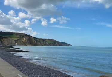
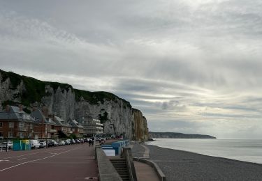
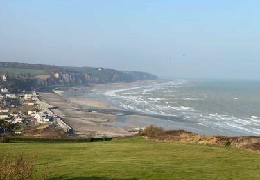
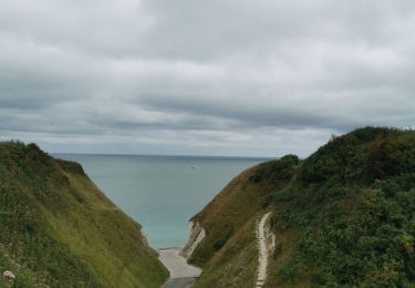
Randonnée V.T.T. de 47 km à découvrir à Normandie, Seine-Maritime, Dieppe. Cette randonnée est proposée par tracegps.
Description
Un très beau circuit dans l’arrière pays dieppois. Il suit les routes de grande randonnée du pays, au long du littoral, et ensuite par trois forets: d'Arques, Pimont, Le Croc (Foret d'Eawy). Le segment par les deux dernières forêts est assez difficile, surtout après la pluie. Le circuit ne pose pas des problèmes particuliers, mais je ne le trouve pas quand même recommandable aux débutants.
Localisation
Commentaires
Randonnées à proximité
![Randonnée Marche Varengeville-sur-Mer - Pourville jusqu'aux Terrasses de Vasterival - Photo](https://media.geolcdn.com/t/375/260/ext.jpg?maxdim=2&url=https%3A%2F%2Fstatic1.geolcdn.com%2Fsiteimages%2Fupload%2Ffiles%2F1553511878bg_sport_marche.png)
![Marche Marche](https://static1.geolcdn.com/sitytour/trail-icons/101.png)
Marche
![](/images/other/stat-length.png)
![](https://static1.geolcdn.com/siteimages/upload/files/16400158638029165_repeat_loop_refresh_sync_direction_icon.png)
![Randonnée Marche Dieppe - GR21 : De Dieppe à Pourville-Sur-Mer - Photo](https://media.geolcdn.com/t/375/260/9af66fc9-7eaf-4a54-b63d-df14d7092c30.jpeg&format=jpg&maxdim=2)
![Marche Marche](https://static1.geolcdn.com/sitytour/trail-icons/101.png)
Marche
![](/images/other/stat-length.png)
![](https://static1.geolcdn.com/siteimages/upload/files/16400158638029165_repeat_loop_refresh_sync_direction_icon.png)
![Randonnée A pied Dieppe - Dieppe coté mer 1 - Photo](https://media.geolcdn.com/t/375/260/17716324-48c0-4442-af65-fedeb6808833.jpeg&format=jpg&maxdim=2)
![A pied A pied](https://static1.geolcdn.com/sitytour/trail-icons/100.png)
A pied
![](/images/other/stat-length.png)
![](https://static1.geolcdn.com/siteimages/upload/files/16400158638029165_repeat_loop_refresh_sync_direction_icon.png)
![Randonnée Marche Hautot-sur-Mer - Autour de Varengeville-sur-Mer - Photo](https://media.geolcdn.com/t/375/260/60d902af-7cf1-469a-9cec-da74be4158a3.jpeg&format=jpg&maxdim=2)
![Marche Marche](https://static1.geolcdn.com/sitytour/trail-icons/101.png)
Marche
![](/images/other/stat-length.png)
![](https://static1.geolcdn.com/siteimages/upload/files/16400158638029165_repeat_loop_refresh_sync_direction_icon.png)
![Randonnée Marche Hautot-sur-Mer - Petit Appeville vers Pourville sur mer - Photo](https://media.geolcdn.com/t/375/260/f27eecc9-b419-4f96-979b-ca5c51e90ae0.jpg&format=jpg&maxdim=2)
![Marche Marche](https://static1.geolcdn.com/sitytour/trail-icons/101.png)
Marche
![](/images/other/stat-length.png)
![](https://static1.geolcdn.com/siteimages/upload/files/16400158638029165_repeat_loop_refresh_sync_direction_icon.png)
![Randonnée Marche Petit-Caux - bracquemont belleville - Photo](https://media.geolcdn.com/t/375/260/da3850e3-aaac-4075-9ca6-53fbc3d5c050.jpg&format=jpg&maxdim=2)
![Marche Marche](https://static1.geolcdn.com/sitytour/trail-icons/101.png)
Marche
![](/images/other/stat-length.png)
![](https://static1.geolcdn.com/siteimages/upload/files/16400158638029165_repeat_loop_refresh_sync_direction_icon.png)
![Vélo électrique Vélo électrique](https://static1.geolcdn.com/sitytour/trail-icons/205.png)
Vélo électrique
![](/images/other/stat-length.png)
![](https://static1.geolcdn.com/siteimages/upload/files/16400158638029165_repeat_loop_refresh_sync_direction_icon.png)
![Randonnée Marche Dieppe - Dieppe - Photo](https://media.geolcdn.com/t/375/260/25ca68d2-67d2-41cc-84f5-ed5d3a2e8f7b.jpg&format=jpg&maxdim=2)
![Marche Marche](https://static1.geolcdn.com/sitytour/trail-icons/101.png)
![Randonnée Marche Hautot-sur-Mer - La route du lin - Photo](https://media.geolcdn.com/t/375/260/58a18e9e-d5e0-45f3-a421-9d8e594845b6.jpg&format=jpg&maxdim=2)
![Marche Marche](https://static1.geolcdn.com/sitytour/trail-icons/101.png)
Marche
![](/images/other/stat-length.png)
![](https://static1.geolcdn.com/siteimages/upload/files/16400158638029165_repeat_loop_refresh_sync_direction_icon.png)