![](/images/other/stat-length.png)
![Randonnée Marche Château-la-Vallière - Château-la-Vallière - Photo](https://media.geolcdn.com/t/1900/400/ext.pjpeg?maxdim=2&url=https%3A%2F%2Fstatic1.geolcdn.com%2Fsiteimages%2Fupload%2Ffiles%2F1553511878bg_sport_marche.png)
Château-la-Vallière
LEMENIO
Utilisateur
![Longueur](/images/other/stat-length.png)
Longueur
15,7 km
![Altitude max](https://static1.geolcdn.com/siteimages/upload/files/1508320355ic_sort_altitude_max_24dp.png)
Altitude max
121 m
![Dénivelé positif](https://static1.geolcdn.com/siteimages/upload/files/1508320355ic_sort_den_pos_24dp.png)
Dénivelé positif
174 m
![Km-Effort](/images/other/stat-length.png)
Km-Effort
18 km
![Altitude min](https://static1.geolcdn.com/siteimages/upload/files/1508320355ic_sort_altitude_min_24dp.png)
Altitude min
64 m
![Dénivelé négatif](https://static1.geolcdn.com/siteimages/upload/files/1508320355ic_sort_den_neg_24dp.png)
Dénivelé négatif
173 m
![Boucle](https://static1.geolcdn.com/siteimages/upload/files/16400158638029165_repeat_loop_refresh_sync_direction_icon.png)
Boucle
Oui
Date de création :
2014-12-10 00:00:00.0
Dernière modification :
2014-12-10 00:00:00.0
![Marche](https://static1.geolcdn.com/sitytour/trail-icons/101.png)
3h28
Difficulté : Moyen
![Scannez ce code QR pour ouvrir la randonnée dans l'application SityTrail](https://capi.geolives.com/qq0zvz2zws4bq2lad0pu/sitytour/trails/116005/qr.png?size=200)
Application GPS de randonnée GRATUITE
À propos
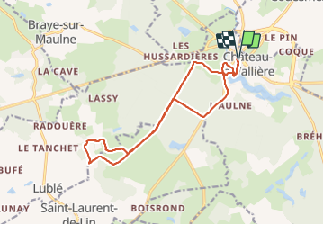
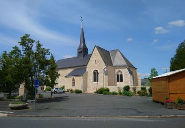
Randonnée Marche de 15,7 km à découvrir à Centre-Val de Loire, Indre-et-Loire, Château-la-Vallière. Cette randonnée est proposée par LEMENIO.
Description
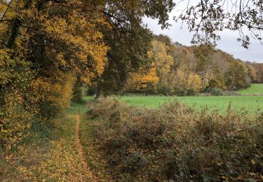
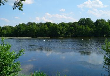
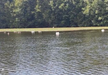
Randonnée des trois gués. Départ rue du 11 novembre 1918 près de monument aux morts. En début de ballade,et arrivé à l'étang, le chemin passe sous le porche du bâtiment en bois.
Localisation
Pays :
France
Région :
Centre-Val de Loire
Département/Province :
Indre-et-Loire
Commune :
Château-la-Vallière
Localité :
Unknown
Départ:(Dec)
Départ:(UTM)
298297 ; 5269536 (31T) N.
Commentaires
Randonnées à proximité
![Randonnée Marche Couesmes - Couesmes Château-la-Vallière la Gare - PR GRP Castelvalérie Marcilly Braye Villiers - 27km 280m 6h05 (40mn) - 2024 11 13 - Photo](https://media.geolcdn.com/t/375/260/a6ed14d6-cf1f-4346-965d-10cf16b9f80b.jpg&format=jpg&maxdim=2)
![Marche Marche](https://static1.geolcdn.com/sitytour/trail-icons/101.png)
Couesmes Château-la-Vallière la Gare - PR GRP Castelvalérie Marcilly Braye Vi...
Marche
Moyen
Couesmes,
Centre-Val de Loire,
Indre-et-Loire,
France
![](/images/other/stat-length.png)
27 km | 31 km-effort
6h 5min
![](https://static1.geolcdn.com/siteimages/upload/files/16400158638029165_repeat_loop_refresh_sync_direction_icon.png)
Oui
![Randonnée Marche Château-la-Vallière - Château-la-Vallière - Lac du Val Joyeux - 6.1km 70m 1h30 - 2023 06 07 - Photo](https://media.geolcdn.com/t/375/260/5ac883b9-c1e1-4571-ae83-aede517b82a5.jpg&format=jpg&maxdim=2)
![Marche Marche](https://static1.geolcdn.com/sitytour/trail-icons/101.png)
Château-la-Vallière - Lac du Val Joyeux - 6.1km 70m 1h30 - 2023 06 07
Marche
Facile
Château-la-Vallière,
Centre-Val de Loire,
Indre-et-Loire,
France
![](/images/other/stat-length.png)
6,1 km | 7 km-effort
1h 30min
![](https://static1.geolcdn.com/siteimages/upload/files/16400158638029165_repeat_loop_refresh_sync_direction_icon.png)
Oui
![Randonnée Marche Saint-Laurent-de-Lin - Saint-Laurent-de-Lin - GRP Castelvalérie Lublé - 13.3km 70m 3h00 (35mn) - 2023 05 27 - Photo](https://media.geolcdn.com/t/375/260/4d8dbac5-78d6-451e-9994-19b790aab408.jpg&format=jpg&maxdim=2)
![Marche Marche](https://static1.geolcdn.com/sitytour/trail-icons/101.png)
Saint-Laurent-de-Lin - GRP Castelvalérie Lublé - 13.3km 70m 3h00 (35mn) - 202...
Marche
Facile
Saint-Laurent-de-Lin,
Centre-Val de Loire,
Indre-et-Loire,
France
![](/images/other/stat-length.png)
13,3 km | 14,3 km-effort
3h 0min
![](https://static1.geolcdn.com/siteimages/upload/files/16400158638029165_repeat_loop_refresh_sync_direction_icon.png)
Oui
![Randonnée Marche Château-la-Vallière - Château-la-Vallière - GRP Castelvalérie Villiers-au-Bouin Couesmes - 22.7km 180m 5h15 (35mn) - 2023 05 18 - Photo](https://media.geolcdn.com/t/375/260/a3f39e88-89ba-4ca0-a948-b1b82e0807d3.jpg&format=jpg&maxdim=2)
![Marche Marche](https://static1.geolcdn.com/sitytour/trail-icons/101.png)
Château-la-Vallière - GRP Castelvalérie Villiers-au-Bouin Couesmes - 22.7km 1...
Marche
Facile
Château-la-Vallière,
Centre-Val de Loire,
Indre-et-Loire,
France
![](/images/other/stat-length.png)
22 km | 25 km-effort
5h 15min
![](https://static1.geolcdn.com/siteimages/upload/files/16400158638029165_repeat_loop_refresh_sync_direction_icon.png)
Oui
![Randonnée Marche Château-la-Vallière - Chateau la Vallières.11,4 Km.Le 29 Octobre 2015.Auteur tintin37 - Photo](https://media.geolcdn.com/t/375/260/ext.jpg?maxdim=2&url=https%3A%2F%2Fstatic1.geolcdn.com%2Fsiteimages%2Fupload%2Ffiles%2F1553511878bg_sport_marche.png)
![Marche Marche](https://static1.geolcdn.com/sitytour/trail-icons/101.png)
Chateau la Vallières.11,4 Km.Le 29 Octobre 2015.Auteur tintin37
Marche
Moyen
(2)
Château-la-Vallière,
Centre-Val de Loire,
Indre-et-Loire,
France
![](/images/other/stat-length.png)
11,4 km | 13,1 km-effort
2h 44min
![](https://static1.geolcdn.com/siteimages/upload/files/16400158638029165_repeat_loop_refresh_sync_direction_icon.png)
Oui
![Randonnée Marche Château-la-Vallière - Château Lavalière - Photo](https://media.geolcdn.com/t/375/260/a7d0b3f7-9bff-4f79-abe1-0ef5d0a77e13.jpg&format=jpg&maxdim=2)
![Marche Marche](https://static1.geolcdn.com/sitytour/trail-icons/101.png)
Château Lavalière
Marche
Facile
Château-la-Vallière,
Centre-Val de Loire,
Indre-et-Loire,
France
![](/images/other/stat-length.png)
5,3 km | 5,9 km-effort
56min
![](https://static1.geolcdn.com/siteimages/upload/files/16400158638029165_repeat_loop_refresh_sync_direction_icon.png)
Oui
![Randonnée Marche Château-la-Vallière - Chateau la Vallières-11,6km-Le-Auteur tintin37 - Photo](https://media.geolcdn.com/t/375/260/ext.jpg?maxdim=2&url=https%3A%2F%2Fstatic1.geolcdn.com%2Fsiteimages%2Fupload%2Ffiles%2F1553511878bg_sport_marche.png)
![Marche Marche](https://static1.geolcdn.com/sitytour/trail-icons/101.png)
Chateau la Vallières-11,6km-Le-Auteur tintin37
Marche
Moyen
Château-la-Vallière,
Centre-Val de Loire,
Indre-et-Loire,
France
![](/images/other/stat-length.png)
11,5 km | 13,1 km-effort
2h 53min
![](https://static1.geolcdn.com/siteimages/upload/files/16400158638029165_repeat_loop_refresh_sync_direction_icon.png)
Oui
![Randonnée Vélo électrique Couesmes - 2024-05-09 - Photo](https://media.geolcdn.com/t/375/260/ext.jpg?maxdim=2&url=https%3A%2F%2Fstatic1.geolcdn.com%2Fsiteimages%2Fupload%2Ffiles%2F1524743154velo.jpg)
![Vélo électrique Vélo électrique](https://static1.geolcdn.com/sitytour/trail-icons/205.png)
2024-05-09
Vélo électrique
Facile
Couesmes,
Centre-Val de Loire,
Indre-et-Loire,
France
![](/images/other/stat-length.png)
25 km | 28 km-effort
1h 30min
![](https://static1.geolcdn.com/siteimages/upload/files/16400158638029165_repeat_loop_refresh_sync_direction_icon.png)
Oui
![Randonnée Vélo de route Château-la-Vallière - 1nov 2019 - Photo](https://media.geolcdn.com/t/375/260/ext.jpg?maxdim=2&url=https%3A%2F%2Fstatic1.geolcdn.com%2Fsiteimages%2Fupload%2Ffiles%2F1524743154velo.jpg)
![Vélo de route Vélo de route](https://static1.geolcdn.com/sitytour/trail-icons/201.png)
1nov 2019
Vélo de route
Château-la-Vallière,
Centre-Val de Loire,
Indre-et-Loire,
France
![](/images/other/stat-length.png)
57 km | 66 km-effort
2h 20min
![](https://static1.geolcdn.com/siteimages/upload/files/16400158638029165_repeat_loop_refresh_sync_direction_icon.png)
Non