![](/images/other/stat-length.png)
![Randonnée Marche Nouzilly - Nouzilly - Photo](https://media.geolcdn.com/t/1900/400/ext.pjpeg?maxdim=2&url=https%3A%2F%2Fstatic1.geolcdn.com%2Fsiteimages%2Fupload%2Ffiles%2F1553511878bg_sport_marche.png)
Nouzilly
LEMENIO
Utilisateur
![Longueur](/images/other/stat-length.png)
Longueur
13,2 km
![Altitude max](https://static1.geolcdn.com/siteimages/upload/files/1508320355ic_sort_altitude_max_24dp.png)
Altitude max
144 m
![Dénivelé positif](https://static1.geolcdn.com/siteimages/upload/files/1508320355ic_sort_den_pos_24dp.png)
Dénivelé positif
192 m
![Km-Effort](/images/other/stat-length.png)
Km-Effort
15,7 km
![Altitude min](https://static1.geolcdn.com/siteimages/upload/files/1508320355ic_sort_altitude_min_24dp.png)
Altitude min
88 m
![Dénivelé négatif](https://static1.geolcdn.com/siteimages/upload/files/1508320355ic_sort_den_neg_24dp.png)
Dénivelé négatif
191 m
![Boucle](https://static1.geolcdn.com/siteimages/upload/files/16400158638029165_repeat_loop_refresh_sync_direction_icon.png)
Boucle
Oui
Date de création :
2014-12-10 00:00:00.0
Dernière modification :
2014-12-10 00:00:00.0
![Marche](https://static1.geolcdn.com/sitytour/trail-icons/101.png)
2h56
Difficulté : Facile
![Scannez ce code QR pour ouvrir la randonnée dans l'application SityTrail](https://capi.geolives.com/qq0zvz2zws4bq2lad0pu/sitytour/trails/114735/qr.png?size=200)
Application GPS de randonnée GRATUITE
À propos
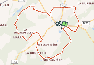
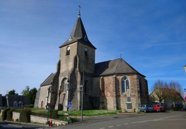
Randonnée Marche de 13,2 km à découvrir à Centre-Val de Loire, Indre-et-Loire, Nouzilly. Cette randonnée est proposée par LEMENIO.
Description
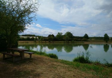
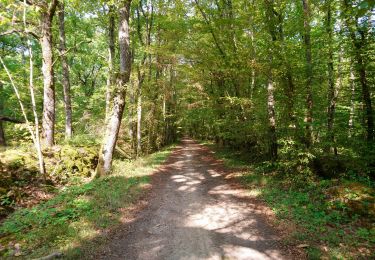
Départ : parking de l'étang communal avenue du lac. Au début du 1er kilomètre au nord du village, vous êtes sur les restes d'un fossé rectiligne est-ouest attribué aux Romains et dit Fossés de César.
Localisation
Pays :
France
Région :
Centre-Val de Loire
Département/Province :
Indre-et-Loire
Commune :
Nouzilly
Localité :
Unknown
Départ:(Dec)
Départ:(UTM)
330295 ; 5267649 (31T) N.
Commentaires
Randonnées à proximité
![Randonnée Marche Cerelles - Cerelles - Photo](https://media.geolcdn.com/t/375/260/ext.jpg?maxdim=2&url=https%3A%2F%2Fservices.sitytrail.com%2FGeolivesWS%2FDownloadMedia.ashx%3FTrailID%3D231250%26Media%3Dfix__20131106141542.jpg)
![Marche Marche](https://static1.geolcdn.com/sitytour/trail-icons/101.png)
Cerelles
Marche
Facile
(1)
Cerelles,
Centre-Val de Loire,
Indre-et-Loire,
France
![](/images/other/stat-length.png)
10,5 km | 12,5 km-effort
2h 42min
![](https://static1.geolcdn.com/siteimages/upload/files/16400158638029165_repeat_loop_refresh_sync_direction_icon.png)
Oui
![Randonnée Marche Monnaie - Monnaie - 4.3km 33m 1h05 - 2023 07 26 - Photo](https://media.geolcdn.com/t/375/260/e63dbb26-070f-44c2-b6bb-6676aa2a7839.jpg&format=jpg&maxdim=2)
![Marche Marche](https://static1.geolcdn.com/sitytour/trail-icons/101.png)
Monnaie - 4.3km 33m 1h05 - 2023 07 26
Marche
Très facile
Monnaie,
Centre-Val de Loire,
Indre-et-Loire,
France
![](/images/other/stat-length.png)
4,3 km | 4,7 km-effort
1h 5min
![](https://static1.geolcdn.com/siteimages/upload/files/16400158638029165_repeat_loop_refresh_sync_direction_icon.png)
Oui
![Randonnée Marche Nouzilly - Nouzilly - Circuit des Orchidées - 22.4km 375m 5h10 - 2022 04 10 - Photo](https://media.geolcdn.com/t/375/260/f369628d-ef19-453f-82e0-3cfc95192175.jpg&format=jpg&maxdim=2)
![Marche Marche](https://static1.geolcdn.com/sitytour/trail-icons/101.png)
Nouzilly - Circuit des Orchidées - 22.4km 375m 5h10 - 2022 04 10
Marche
Moyen
Nouzilly,
Centre-Val de Loire,
Indre-et-Loire,
France
![](/images/other/stat-length.png)
22 km | 27 km-effort
5h 10min
![](https://static1.geolcdn.com/siteimages/upload/files/16400158638029165_repeat_loop_refresh_sync_direction_icon.png)
Oui
![Randonnée Marche Cerelles - Cérelles - Circuits 2 puis 1 - 18.9km 255m 4h05 - 2020 09 11 - Photo](https://media.geolcdn.com/t/375/260/2967519f-5900-49cf-b0ee-522e62c44bc9.jpg&format=jpg&maxdim=2)
![Marche Marche](https://static1.geolcdn.com/sitytour/trail-icons/101.png)
Cérelles - Circuits 2 puis 1 - 18.9km 255m 4h05 - 2020 09 11
Marche
Moyen
Cerelles,
Centre-Val de Loire,
Indre-et-Loire,
France
![](/images/other/stat-length.png)
18,9 km | 22 km-effort
4h 5min
![](https://static1.geolcdn.com/siteimages/upload/files/16400158638029165_repeat_loop_refresh_sync_direction_icon.png)
Oui
![Randonnée Marche Nouzilly - Nouzilly - Circuit des Orchidées - Photo](https://media.geolcdn.com/t/375/260/a94eac27-6f2f-438f-99a8-49504ab468e3.jpg&format=jpg&maxdim=2)
![Marche Marche](https://static1.geolcdn.com/sitytour/trail-icons/101.png)
Nouzilly - Circuit des Orchidées
Marche
Difficile
Nouzilly,
Centre-Val de Loire,
Indre-et-Loire,
France
![](/images/other/stat-length.png)
21 km | 26 km-effort
5h 54min
![](https://static1.geolcdn.com/siteimages/upload/files/16400158638029165_repeat_loop_refresh_sync_direction_icon.png)
Oui
![Randonnée Marche Nouzilly - Nouzilly - Cavités troglodytes - Photo](https://media.geolcdn.com/t/375/260/7f01b6f5-4bf2-4f68-8524-f8ef3b2952f7.jpg&format=jpg&maxdim=2)
![Marche Marche](https://static1.geolcdn.com/sitytour/trail-icons/101.png)
Nouzilly - Cavités troglodytes
Marche
Difficile
Nouzilly,
Centre-Val de Loire,
Indre-et-Loire,
France
![](/images/other/stat-length.png)
10,7 km | 12,9 km-effort
2h 56min
![](https://static1.geolcdn.com/siteimages/upload/files/16400158638029165_repeat_loop_refresh_sync_direction_icon.png)
Oui
![Randonnée Marche Cerelles - Cerelles-10,5 km-Le 05 Février 2015-Auteur tintin37 - Photo](https://media.geolcdn.com/t/375/260/ext.jpg?maxdim=2&url=https%3A%2F%2Fstatic1.geolcdn.com%2Fsiteimages%2Fupload%2Ffiles%2F1553511878bg_sport_marche.png)
![Marche Marche](https://static1.geolcdn.com/sitytour/trail-icons/101.png)
Cerelles-10,5 km-Le 05 Février 2015-Auteur tintin37
Marche
Moyen
(1)
Cerelles,
Centre-Val de Loire,
Indre-et-Loire,
France
![](/images/other/stat-length.png)
10,5 km | 12,5 km-effort
2h 44min
![](https://static1.geolcdn.com/siteimages/upload/files/16400158638029165_repeat_loop_refresh_sync_direction_icon.png)
Oui
![Randonnée Marche Rouziers-de-Touraine - 2022.09.22-8.3km-Rouziers de Touraine - Photo](https://media.geolcdn.com/t/375/260/180d9b93-133e-4b36-b79a-af66091ab44a.jpg&format=jpg&maxdim=2)
![Marche Marche](https://static1.geolcdn.com/sitytour/trail-icons/101.png)
2022.09.22-8.3km-Rouziers de Touraine
Marche
Moyen
Rouziers-de-Touraine,
Centre-Val de Loire,
Indre-et-Loire,
France
![](/images/other/stat-length.png)
8,3 km | 9,5 km-effort
2h 16min
![](https://static1.geolcdn.com/siteimages/upload/files/16400158638029165_repeat_loop_refresh_sync_direction_icon.png)
Oui
![Randonnée Marche Monnaie - Monnaie - 19ème rando St-Valentin - 17.8km 155m 3h30 - 2006 02 06 - Photo](https://media.geolcdn.com/t/375/260/ext.jpg?maxdim=2&url=https%3A%2F%2Fstatic1.geolcdn.com%2Fsiteimages%2Fupload%2Ffiles%2F1553511878bg_sport_marche.png)
![Marche Marche](https://static1.geolcdn.com/sitytour/trail-icons/101.png)
Monnaie - 19ème rando St-Valentin - 17.8km 155m 3h30 - 2006 02 06
Marche
Moyen
Monnaie,
Centre-Val de Loire,
Indre-et-Loire,
France
![](/images/other/stat-length.png)
17,8 km | 19,9 km-effort
3h 30min
![](https://static1.geolcdn.com/siteimages/upload/files/16400158638029165_repeat_loop_refresh_sync_direction_icon.png)
Oui