![](/images/other/stat-length.png)
![Randonnée Course à pied La Ferté-Bernard - De St Julien aux champs - Photo](https://media.geolcdn.com/t/1900/400/ext.pjpeg?maxdim=2&url=https%3A%2F%2Fstatic1.geolcdn.com%2Fsiteimages%2Fupload%2Ffiles%2F1524743154running.jpg)
De St Julien aux champs
bobtail63
Utilisateur
![Longueur](/images/other/stat-length.png)
Longueur
8,7 km
![Altitude max](https://static1.geolcdn.com/siteimages/upload/files/1508320355ic_sort_altitude_max_24dp.png)
Altitude max
183 m
![Dénivelé positif](https://static1.geolcdn.com/siteimages/upload/files/1508320355ic_sort_den_pos_24dp.png)
Dénivelé positif
145 m
![Km-Effort](/images/other/stat-length.png)
Km-Effort
10,7 km
![Altitude min](https://static1.geolcdn.com/siteimages/upload/files/1508320355ic_sort_altitude_min_24dp.png)
Altitude min
83 m
![Dénivelé négatif](https://static1.geolcdn.com/siteimages/upload/files/1508320355ic_sort_den_neg_24dp.png)
Dénivelé négatif
145 m
![Boucle](https://static1.geolcdn.com/siteimages/upload/files/16400158638029165_repeat_loop_refresh_sync_direction_icon.png)
Boucle
Oui
Date de création :
2014-12-10 00:00:00.0
Dernière modification :
2014-12-10 00:00:00.0
![Course à pied](https://static1.geolcdn.com/sitytour/trail-icons/103.png)
53m
Difficulté : Très facile
![Scannez ce code QR pour ouvrir la randonnée dans l'application SityTrail](https://capi.geolives.com/qq0zvz2zws4bq2lad0pu/sitytour/trails/114121/qr.png?size=200)
Application GPS de randonnée GRATUITE
À propos
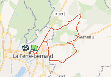
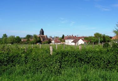
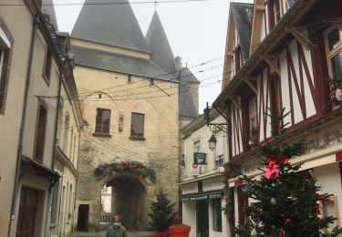
Randonnée Course à pied de 8,7 km à découvrir à Pays de la Loire, Sarthe, La Ferté-Bernard. Cette randonnée est proposée par bobtail63.
Description
Depart du parking derrière saint Julien. Ce tracé permet de s'échauffer sur du bitume avant de rejoindre les chemins et quelques petites montées. Attention, gras en hiver.
Localisation
Pays :
France
Région :
Pays de la Loire
Département/Province :
Sarthe
Commune :
La Ferté-Bernard
Localité :
Unknown
Départ:(Dec)
Départ:(UTM)
325637 ; 5339702 (31U) N.
Commentaires
Randonnées à proximité
![Randonnée Marche Avezé - avezé Sarthe - Photo](https://media.geolcdn.com/t/375/260/ext.jpg?maxdim=2&url=https%3A%2F%2Fservices.sitytrail.com%2FGeolivesWS%2FDownloadMedia.ashx%3FTrailID%3D996959%26Media%3Dfix__20180701132821.jpg)
![Marche Marche](https://static1.geolcdn.com/sitytour/trail-icons/101.png)
avezé Sarthe
Marche
Facile
Avezé,
Pays de la Loire,
Sarthe,
France
![](/images/other/stat-length.png)
13,4 km | 15,9 km-effort
4h 17min
![](https://static1.geolcdn.com/siteimages/upload/files/16400158638029165_repeat_loop_refresh_sync_direction_icon.png)
Oui
![Randonnée Marche Cherré-Au - Cherreau - Sur le sentier des lièvres - Photo](https://media.geolcdn.com/t/375/260/ext.jpg?maxdim=2&url=https%3A%2F%2Fservices.sitytrail.com%2FGeolivesWS%2FDownloadMedia.ashx%3FTrailID%3D110127%26Media%3D5321_1.jpg)
![Marche Marche](https://static1.geolcdn.com/sitytour/trail-icons/101.png)
Cherreau - Sur le sentier des lièvres
Marche
Moyen
Cherré-Au,
Pays de la Loire,
Sarthe,
France
![](/images/other/stat-length.png)
6,7 km | 8,4 km-effort
1h 30min
![](https://static1.geolcdn.com/siteimages/upload/files/16400158638029165_repeat_loop_refresh_sync_direction_icon.png)
Oui
![Randonnée Marche Souvigné-sur-Même - Souvigné sur Même - Paysages de la Vallée de l'Huisne - Photo](https://media.geolcdn.com/t/375/260/ext.jpg?maxdim=2&url=https%3A%2F%2Fservices.sitytrail.com%2FGeolivesWS%2FDownloadMedia.ashx%3FTrailID%3D110083%26Media%3D5244_1.jpg)
![Marche Marche](https://static1.geolcdn.com/sitytour/trail-icons/101.png)
Souvigné sur Même - Paysages de la Vallée de l'Huisne
Marche
Moyen
Souvigné-sur-Même,
Pays de la Loire,
Sarthe,
France
![](/images/other/stat-length.png)
6 km | 7,8 km-effort
1h 30min
![](https://static1.geolcdn.com/siteimages/upload/files/16400158638029165_repeat_loop_refresh_sync_direction_icon.png)
Oui
![Randonnée Marche Avezé - Avezé - Au coeur du bocage percheron - Photo](https://media.geolcdn.com/t/375/260/ext.jpg?maxdim=2&url=https%3A%2F%2Fservices.sitytrail.com%2FGeolivesWS%2FDownloadMedia.ashx%3FTrailID%3D110015%26Media%3D5119_1.jpg)
![Marche Marche](https://static1.geolcdn.com/sitytour/trail-icons/101.png)
Avezé - Au coeur du bocage percheron
Marche
Moyen
Avezé,
Pays de la Loire,
Sarthe,
France
![](/images/other/stat-length.png)
14,6 km | 17,7 km-effort
3h 30min
![](https://static1.geolcdn.com/siteimages/upload/files/16400158638029165_repeat_loop_refresh_sync_direction_icon.png)
Oui
![Randonnée Course à pied La Ferté-Bernard - La Ferté Bernard trace - Photo](https://media.geolcdn.com/t/375/260/ext.jpg?maxdim=2&url=https%3A%2F%2Fmedia.geolcdn.com%2Ff%2Fd16d4168-41ec-4f47-b99c-5168db04f47b.jpg)
![Course à pied Course à pied](https://static1.geolcdn.com/sitytour/trail-icons/103.png)
La Ferté Bernard trace
Course à pied
La Ferté-Bernard,
Pays de la Loire,
Sarthe,
France
![](/images/other/stat-length.png)
9,4 km | 10,1 km-effort
1h 5min
![](https://static1.geolcdn.com/siteimages/upload/files/16400158638029165_repeat_loop_refresh_sync_direction_icon.png)
Oui
![Randonnée V.T.T. La Ferté-Bernard - La Ferté Bernard - Sablé sur Sarthe 3ieme jour - Photo](https://media.geolcdn.com/t/375/260/ext.jpg?maxdim=2&url=https%3A%2F%2Fmedia.geolcdn.com%2Ff%2Ff1adcf78-1864-4c5a-9623-0c71ff50a6a3.jpg)
![V.T.T. V.T.T.](https://static1.geolcdn.com/sitytour/trail-icons/202.png)
La Ferté Bernard - Sablé sur Sarthe 3ieme jour
V.T.T.
Moyen
La Ferté-Bernard,
Pays de la Loire,
Sarthe,
France
![](/images/other/stat-length.png)
103 km | 114 km-effort
6h 1min
![](https://static1.geolcdn.com/siteimages/upload/files/16400158638029165_repeat_loop_refresh_sync_direction_icon.png)
Non
![Randonnée V.T.T. La Ferté-Bernard - Essai BRT J3 103KM D+800 - MATIN 58KM D+ / APRES MIDI 45KM D+ - Photo](https://media.geolcdn.com/t/375/260/ext.jpg?maxdim=2&url=https%3A%2F%2Fstatic1.geolcdn.com%2Fsiteimages%2Fupload%2Ffiles%2F1524743154velo.jpg)
![V.T.T. V.T.T.](https://static1.geolcdn.com/sitytour/trail-icons/202.png)
Essai BRT J3 103KM D+800 - MATIN 58KM D+ / APRES MIDI 45KM D+
V.T.T.
Moyen
La Ferté-Bernard,
Pays de la Loire,
Sarthe,
France
![](/images/other/stat-length.png)
103 km | 114 km-effort
1h 31min
![](https://static1.geolcdn.com/siteimages/upload/files/16400158638029165_repeat_loop_refresh_sync_direction_icon.png)
Non
![Randonnée Autre activité La Ferté-Bernard - R,e,T J3 - Photo](https://media.geolcdn.com/t/375/260/ext.jpg?maxdim=2&url=https%3A%2F%2Fstatic1.geolcdn.com%2Fsiteimages%2Fupload%2Ffiles%2F1545311037marcheuse_200dpi.jpg)
![Autre activité Autre activité](https://static1.geolcdn.com/sitytour/trail-icons/900.png)
R,e,T J3
Autre activité
Très facile
La Ferté-Bernard,
Pays de la Loire,
Sarthe,
France
![](/images/other/stat-length.png)
114 km | 128 km-effort
10h 0min
![](https://static1.geolcdn.com/siteimages/upload/files/16400158638029165_repeat_loop_refresh_sync_direction_icon.png)
Non
![Randonnée Marche Souvigné-sur-Même - Souvigné-sur-Même 10,1km - Photo](https://media.geolcdn.com/t/375/260/ext.jpg?maxdim=2&url=https%3A%2F%2Fstatic1.geolcdn.com%2Fsiteimages%2Fupload%2Ffiles%2F1553511878bg_sport_marche.png)
![Marche Marche](https://static1.geolcdn.com/sitytour/trail-icons/101.png)
Souvigné-sur-Même 10,1km
Marche
Facile
(1)
Souvigné-sur-Même,
Pays de la Loire,
Sarthe,
France
![](/images/other/stat-length.png)
10,1 km | 12,2 km-effort
2h 40min
![](https://static1.geolcdn.com/siteimages/upload/files/16400158638029165_repeat_loop_refresh_sync_direction_icon.png)
Oui