![](/images/other/stat-length.png)
![Randonnée Marche Neuillé-Pont-Pierre - Neuillé-Pont-Pierre circuit nord - Photo](https://media.geolcdn.com/t/1900/400/ext.pjpeg?maxdim=2&url=https%3A%2F%2Fstatic1.geolcdn.com%2Fsiteimages%2Fupload%2Ffiles%2F1553511878bg_sport_marche.png)
Neuillé-Pont-Pierre circuit nord
LEMENIO
Utilisateur
![Longueur](/images/other/stat-length.png)
Longueur
12,9 km
![Altitude max](https://static1.geolcdn.com/siteimages/upload/files/1508320355ic_sort_altitude_max_24dp.png)
Altitude max
122 m
![Dénivelé positif](https://static1.geolcdn.com/siteimages/upload/files/1508320355ic_sort_den_pos_24dp.png)
Dénivelé positif
91 m
![Km-Effort](/images/other/stat-length.png)
Km-Effort
14,1 km
![Altitude min](https://static1.geolcdn.com/siteimages/upload/files/1508320355ic_sort_altitude_min_24dp.png)
Altitude min
80 m
![Dénivelé négatif](https://static1.geolcdn.com/siteimages/upload/files/1508320355ic_sort_den_neg_24dp.png)
Dénivelé négatif
89 m
![Boucle](https://static1.geolcdn.com/siteimages/upload/files/16400158638029165_repeat_loop_refresh_sync_direction_icon.png)
Boucle
Oui
Date de création :
2014-12-10 00:00:00.0
Dernière modification :
2014-12-10 00:00:00.0
![Marche](https://static1.geolcdn.com/sitytour/trail-icons/101.png)
2h56
Difficulté : Facile
![Scannez ce code QR pour ouvrir la randonnée dans l'application SityTrail](https://capi.geolives.com/qq0zvz2zws4bq2lad0pu/sitytour/trails/114117/qr.png?size=200)
Application GPS de randonnée GRATUITE
À propos
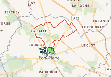
Randonnée Marche de 12,9 km à découvrir à Centre-Val de Loire, Indre-et-Loire, Neuillé-Pont-Pierre. Cette randonnée est proposée par LEMENIO.
Description
Départ Place du Mail. Au lieu-dit "les maisons blanches" traverser la cour pour prendre de chemin (30 mètres). Après la Godardière (à 9,7 Km), 500 mètres de route goudronnée (D68) et prendre le chemin 100 mètres après le passage à niveau.
Localisation
Pays :
France
Région :
Centre-Val de Loire
Département/Province :
Indre-et-Loire
Commune :
Neuillé-Pont-Pierre
Localité :
Unknown
Départ:(Dec)
Départ:(UTM)
315286 ; 5268910 (31T) N.
Commentaires
Randonnées à proximité
![Randonnée Marche Neuillé-Pont-Pierre - Neuillé-Pont-Pierre - la Gare - 13.2km 95m 3h00 - 2021 06 06 - Photo](https://media.geolcdn.com/t/375/260/cfc5750c-c28e-4015-8ebd-f7d2fbbd4acb.jpg&format=jpg&maxdim=2)
![Marche Marche](https://static1.geolcdn.com/sitytour/trail-icons/101.png)
Neuillé-Pont-Pierre - la Gare - 13.2km 95m 3h00 - 2021 06 06
Marche
Facile
Neuillé-Pont-Pierre,
Centre-Val de Loire,
Indre-et-Loire,
France
![](/images/other/stat-length.png)
13,2 km | 14,4 km-effort
3h 0min
![](https://static1.geolcdn.com/siteimages/upload/files/16400158638029165_repeat_loop_refresh_sync_direction_icon.png)
Oui
![Randonnée Marche Neuillé-Pont-Pierre - Neuillé-Pont-Pierre - Circuit 1 - 9.9km 75m 2h00 - 2020 08 22 - Photo](https://media.geolcdn.com/t/375/260/9539092d-241c-4ca6-b996-b5b5dff06d3f.jpg&format=jpg&maxdim=2)
![Marche Marche](https://static1.geolcdn.com/sitytour/trail-icons/101.png)
Neuillé-Pont-Pierre - Circuit 1 - 9.9km 75m 2h00 - 2020 08 22
Marche
Très facile
Neuillé-Pont-Pierre,
Centre-Val de Loire,
Indre-et-Loire,
France
![](/images/other/stat-length.png)
9,9 km | 10,9 km-effort
2h 0min
![](https://static1.geolcdn.com/siteimages/upload/files/16400158638029165_repeat_loop_refresh_sync_direction_icon.png)
Oui
![Randonnée Marche Sonzay - Sonzay nord - Photo](https://media.geolcdn.com/t/375/260/ext.jpg?maxdim=2&url=https%3A%2F%2Fstatic1.geolcdn.com%2Fsiteimages%2Fupload%2Ffiles%2F1553511878bg_sport_marche.png)
![Marche Marche](https://static1.geolcdn.com/sitytour/trail-icons/101.png)
Sonzay nord
Marche
Très facile
Sonzay,
Centre-Val de Loire,
Indre-et-Loire,
France
![](/images/other/stat-length.png)
9,1 km | 10,2 km-effort
2h 1min
![](https://static1.geolcdn.com/siteimages/upload/files/16400158638029165_repeat_loop_refresh_sync_direction_icon.png)
Oui
![Randonnée Marche Semblançay - Neuillé Pont Pierre - 8,4 km - Le 10 Juillet 2014 - Auteur tintin37 - Photo](https://media.geolcdn.com/t/375/260/ext.jpg?maxdim=2&url=https%3A%2F%2Fstatic1.geolcdn.com%2Fsiteimages%2Fupload%2Ffiles%2F1553511878bg_sport_marche.png)
![Marche Marche](https://static1.geolcdn.com/sitytour/trail-icons/101.png)
Neuillé Pont Pierre - 8,4 km - Le 10 Juillet 2014 - Auteur tintin37
Marche
Facile
Semblançay,
Centre-Val de Loire,
Indre-et-Loire,
France
![](/images/other/stat-length.png)
8,4 km | 9,2 km-effort
2h 6min
![](https://static1.geolcdn.com/siteimages/upload/files/16400158638029165_repeat_loop_refresh_sync_direction_icon.png)
Oui
![Randonnée V.T.T. Saint-Paterne-Racan - saint paterne-sonzay - Photo](https://media.geolcdn.com/t/375/260/ext.jpg?maxdim=2&url=https%3A%2F%2Fstatic1.geolcdn.com%2Fsiteimages%2Fupload%2Ffiles%2F1524743154velo.jpg)
![V.T.T. V.T.T.](https://static1.geolcdn.com/sitytour/trail-icons/202.png)
saint paterne-sonzay
V.T.T.
Moyen
Saint-Paterne-Racan,
Centre-Val de Loire,
Indre-et-Loire,
France
![](/images/other/stat-length.png)
28 km | 31 km-effort
1h 57min
![](https://static1.geolcdn.com/siteimages/upload/files/16400158638029165_repeat_loop_refresh_sync_direction_icon.png)
Oui
![Randonnée Marche Neuillé-Pont-Pierre - Neuillé-Pont-Pierre circuit sud - Photo](https://media.geolcdn.com/t/375/260/ext.jpg?maxdim=2&url=https%3A%2F%2Fstatic1.geolcdn.com%2Fsiteimages%2Fupload%2Ffiles%2F1553511878bg_sport_marche.png)
![Marche Marche](https://static1.geolcdn.com/sitytour/trail-icons/101.png)
Neuillé-Pont-Pierre circuit sud
Marche
Facile
Neuillé-Pont-Pierre,
Centre-Val de Loire,
Indre-et-Loire,
France
![](/images/other/stat-length.png)
10,9 km | 12 km-effort
2h 22min
![](https://static1.geolcdn.com/siteimages/upload/files/16400158638029165_repeat_loop_refresh_sync_direction_icon.png)
Non
![Randonnée Marche Sonzay - Sonzay variante chevreuils 12,2km - Photo](https://media.geolcdn.com/t/375/260/ext.jpg?maxdim=2&url=https%3A%2F%2Fstatic1.geolcdn.com%2Fsiteimages%2Fupload%2Ffiles%2F1553511878bg_sport_marche.png)
![Marche Marche](https://static1.geolcdn.com/sitytour/trail-icons/101.png)
Sonzay variante chevreuils 12,2km
Marche
Facile
Sonzay,
Centre-Val de Loire,
Indre-et-Loire,
France
![](/images/other/stat-length.png)
12,2 km | 13,6 km-effort
2h 30min
![](https://static1.geolcdn.com/siteimages/upload/files/16400158638029165_repeat_loop_refresh_sync_direction_icon.png)
Oui
![Randonnée Marche Semblançay - 2023.12.14 - 8.7 km - Neuillé bois du Moines - Photo](https://media.geolcdn.com/t/375/260/ext.jpg?maxdim=2&url=https%3A%2F%2Fstatic1.geolcdn.com%2Fsiteimages%2Fupload%2Ffiles%2F1553511878bg_sport_marche.png)
![Marche Marche](https://static1.geolcdn.com/sitytour/trail-icons/101.png)
2023.12.14 - 8.7 km - Neuillé bois du Moines
Marche
Moyen
Semblançay,
Centre-Val de Loire,
Indre-et-Loire,
France
![](/images/other/stat-length.png)
8,7 km | 9,6 km-effort
2h 29min
![](https://static1.geolcdn.com/siteimages/upload/files/16400158638029165_repeat_loop_refresh_sync_direction_icon.png)
Oui
![Randonnée Marche Semblançay - Le 2022.10.27-8.7 km-Neuillé Pont Pierre Bois du Mortier aux Moines - Photo](https://media.geolcdn.com/t/375/260/ext.jpg?maxdim=2&url=https%3A%2F%2Fstatic1.geolcdn.com%2Fsiteimages%2Fupload%2Ffiles%2F1553511878bg_sport_marche.png)
![Marche Marche](https://static1.geolcdn.com/sitytour/trail-icons/101.png)
Le 2022.10.27-8.7 km-Neuillé Pont Pierre Bois du Mortier aux Moines
Marche
Moyen
Semblançay,
Centre-Val de Loire,
Indre-et-Loire,
France
![](/images/other/stat-length.png)
8,7 km | 9,6 km-effort
2h 26min
![](https://static1.geolcdn.com/siteimages/upload/files/16400158638029165_repeat_loop_refresh_sync_direction_icon.png)
Oui