![](/images/other/stat-length.png)
![Randonnée Marche Saint-Germain-le-Vieux - Le Chemin Vert (Boucle) - Photo](https://media.geolcdn.com/t/1900/400/ext.pjpeg?maxdim=2&url=https%3A%2F%2Fstatic1.geolcdn.com%2Fsiteimages%2Fupload%2Ffiles%2F1553511878bg_sport_marche.png)
Le Chemin Vert (Boucle)
neitag61
Utilisateur
![Longueur](/images/other/stat-length.png)
Longueur
4,8 km
![Altitude max](https://static1.geolcdn.com/siteimages/upload/files/1508320355ic_sort_altitude_max_24dp.png)
Altitude max
235 m
![Dénivelé positif](https://static1.geolcdn.com/siteimages/upload/files/1508320355ic_sort_den_pos_24dp.png)
Dénivelé positif
41 m
![Km-Effort](/images/other/stat-length.png)
Km-Effort
5,3 km
![Altitude min](https://static1.geolcdn.com/siteimages/upload/files/1508320355ic_sort_altitude_min_24dp.png)
Altitude min
208 m
![Dénivelé négatif](https://static1.geolcdn.com/siteimages/upload/files/1508320355ic_sort_den_neg_24dp.png)
Dénivelé négatif
41 m
![Boucle](https://static1.geolcdn.com/siteimages/upload/files/16400158638029165_repeat_loop_refresh_sync_direction_icon.png)
Boucle
Oui
Date de création :
2016-04-15 00:00:00.0
Dernière modification :
2016-04-15 00:00:00.0
![Marche](https://static1.geolcdn.com/sitytour/trail-icons/101.png)
1h40
Difficulté : Très facile
![Scannez ce code QR pour ouvrir la randonnée dans l'application SityTrail](https://capi.geolives.com/qq0zvz2zws4bq2lad0pu/sitytour/trails/114004/qr.png?size=200)
Application GPS de randonnée GRATUITE
À propos
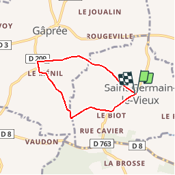
Randonnée Marche de 4,8 km à découvrir à Normandie, Orne, Saint-Germain-le-Vieux. Cette randonnée est proposée par neitag61.
Description
Petit circuit idéal à parcourir en famille, ou pour flâner. Un petit tour dans l''église de St Germain le Vieux avec sa chapelle du XVII eme siecle.
Localisation
Pays :
France
Région :
Normandie
Département/Province :
Orne
Commune :
Saint-Germain-le-Vieux
Localité :
Unknown
Départ:(Dec)
Départ:(UTM)
301980 ; 5387786 (31U) N.
Commentaires
Randonnées à proximité
![Randonnée Marche Ferrières-la-Verrerie - Ferrière La-Chênee - Photo](https://media.geolcdn.com/t/375/260/33487492-eff0-486a-875b-bd5c4a035f32.jpg&format=jpg&maxdim=2)
![Marche Marche](https://static1.geolcdn.com/sitytour/trail-icons/101.png)
Ferrière La-Chênee
Marche
Facile
Ferrières-la-Verrerie,
Normandie,
Orne,
France
![](/images/other/stat-length.png)
9,7 km | 11,4 km-effort
2h 24min
![](https://static1.geolcdn.com/siteimages/upload/files/16400158638029165_repeat_loop_refresh_sync_direction_icon.png)
Oui
![Randonnée V.T.T. Ferrières-la-Verrerie - Moulins la Marche - De Ferrières la Verrerie à Mahéru - Photo](https://media.geolcdn.com/t/375/260/ext.jpg?maxdim=2&url=https%3A%2F%2Fstatic1.geolcdn.com%2Fsiteimages%2Fupload%2Ffiles%2F1524743154velo.jpg)
![V.T.T. V.T.T.](https://static1.geolcdn.com/sitytour/trail-icons/202.png)
Moulins la Marche - De Ferrières la Verrerie à Mahéru
V.T.T.
Difficile
Ferrières-la-Verrerie,
Normandie,
Orne,
France
![](/images/other/stat-length.png)
48 km | 58 km-effort
3h 30min
![](https://static1.geolcdn.com/siteimages/upload/files/16400158638029165_repeat_loop_refresh_sync_direction_icon.png)
Oui
![Randonnée Marche Ferrières-la-Verrerie - Ferrières - Photo](https://media.geolcdn.com/t/375/260/ext.jpg?maxdim=2&url=https%3A%2F%2Fstatic1.geolcdn.com%2Fsiteimages%2Fupload%2Ffiles%2F1553511878bg_sport_marche.png)
![Marche Marche](https://static1.geolcdn.com/sitytour/trail-icons/101.png)
Ferrières
Marche
Moyen
Ferrières-la-Verrerie,
Normandie,
Orne,
France
![](/images/other/stat-length.png)
5,6 km | 6,4 km-effort
1h 26min
![](https://static1.geolcdn.com/siteimages/upload/files/16400158638029165_repeat_loop_refresh_sync_direction_icon.png)
Non
![Randonnée Voiture Ferrières-la-Verrerie - Ferrière-Sees - Photo](https://media.geolcdn.com/t/375/260/ext.jpg?maxdim=2&url=https%3A%2F%2Fstatic1.geolcdn.com%2Fsiteimages%2Fupload%2Ffiles%2F15247431544x4.jpg)
![Voiture Voiture](https://static1.geolcdn.com/sitytour/trail-icons/401.png)
Ferrière-Sees
Voiture
Très facile
Ferrières-la-Verrerie,
Normandie,
Orne,
France
![](/images/other/stat-length.png)
38 km | 43 km-effort
1h 31min
![](https://static1.geolcdn.com/siteimages/upload/files/16400158638029165_repeat_loop_refresh_sync_direction_icon.png)
Oui
![Randonnée Marche Ferrières-la-Verrerie - FERRIÈRE St-Vandrille - Photo](https://media.geolcdn.com/t/375/260/ext.jpg?maxdim=2&url=https%3A%2F%2Fstatic1.geolcdn.com%2Fsiteimages%2Fupload%2Ffiles%2F1553511878bg_sport_marche.png)
![Marche Marche](https://static1.geolcdn.com/sitytour/trail-icons/101.png)
FERRIÈRE St-Vandrille
Marche
Très facile
Ferrières-la-Verrerie,
Normandie,
Orne,
France
![](/images/other/stat-length.png)
8,7 km | 10,1 km-effort
1h 29min
![](https://static1.geolcdn.com/siteimages/upload/files/16400158638029165_repeat_loop_refresh_sync_direction_icon.png)
Oui
![Randonnée Marche Ferrières-la-Verrerie - FERRIÈRE Brossette - Photo](https://media.geolcdn.com/t/375/260/ext.jpg?maxdim=2&url=https%3A%2F%2Fstatic1.geolcdn.com%2Fsiteimages%2Fupload%2Ffiles%2F1553511878bg_sport_marche.png)
![Marche Marche](https://static1.geolcdn.com/sitytour/trail-icons/101.png)
FERRIÈRE Brossette
Marche
Très facile
Ferrières-la-Verrerie,
Normandie,
Orne,
France
![](/images/other/stat-length.png)
3,6 km | 4,8 km-effort
35min
![](https://static1.geolcdn.com/siteimages/upload/files/16400158638029165_repeat_loop_refresh_sync_direction_icon.png)
Non