Randonnée Marche Maron - Maron 15 000m +300m - Photo
 DanielROLLET
DanielROLLET

Utilisateur

© OpenStreetMap contributors
Longueur
Longueur
14,7 km
Altitude max
Altitude max
341 m
Dénivelé positif
Dénivelé positif
301 m
Km-Effort
Km-Effort  
18,7 km
Altitude min
Altitude min
210 m
Dénivelé négatif
Dénivelé négatif
300 m
Boucle
Boucle
Oui
Date de création :
2019-05-07 00:13:53.511
Dernière modification :
2019-05-07 00:13:53.511

(0 Avis)

Marche
Marche
4h05
Difficulté : Moyen

Scannez ce code QR pour ouvrir la randonnée dans l'application SityTrail

Application GPS de randonnée GRATUITE

Logo SityTrail SityTrail

IGN / Instituts géographiques

Télécharger SityTrail sur l'App Store Télécharger SityTrail sur Google Play

Logo SityTrail SityTrail World

Le monde est à vous

Télécharger SityTrail sur l'App Store Télécharger SityTrail sur Google Play Télécharger SityTrail sur Huawei AppGallery

À propos

Randonnée Marche de 14,7 km à découvrir à Grand Est, Meurthe-et-Moselle, Maron. Cette randonnée est proposée par DanielROLLET.

Description

2019 04 07 Rando ASPV 5 personnes
Festival rando Maron
9h00 à 12h50

Profil altimétrique

Points d'intérêt

Point d'intérêt Pont-Saint-Vincent - ravito - Photo
DanielROLLET
PONT-SAINT-VINCENT 
Point d'intérêt Chaligny - ravito - Photo
DanielROLLET
CHALIGNY 

Localisation

Pays :
France
Région :
Grand Est
Département/Province :
Meurthe-et-Moselle
Commune :
Maron
Localité :
Unknown
Départ:(Dec)
Départ:(UTM)
282233 ; 5391308 (32U) N.

Randonnées à proximité

Randonnée Cheval Villey-le-Sec - La Poudrière - Villey le Sec - Photo
Cheval
tracegps

Cheval

Moyen
(1)
Villey-le-Sec, Grand Est, Meurthe-et-Moselle, France
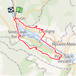
8,6 km | 10,7 km-effort
1h 30min
Oui
Randonnée Marche Villers-lès-Nancy - RANDO DUO AVEC ALEXIS - Photo
Marche
Toyot 8

Marche

Difficile
(1)
Villers-lès-Nancy, Grand Est, Meurthe-et-Moselle, France
38 km | 45 km-effort
10h 19min
Non
Randonnée Marche Sexey-aux-Forges - Sexey Aux Forges - Photo
Marche
pgalet

Marche

Très difficile
Sexey-aux-Forges, Grand Est, Meurthe-et-Moselle, France
31 km | 38 km-effort
2h 38min
Non
Randonnée Marche Villey-le-Sec - Villey le sec - Les grottes - Le fort - Photo
Marche
jean-marie.parachini

Marche

Moyen
Villey-le-Sec, Grand Est, Meurthe-et-Moselle, France
10,5 km | 12,5 km-effort
4h 30min
Oui
Randonnée Marche Maizières - viterne du 14.12.2013 - Photo
Marche
castelli

Marche

Facile
(2)
Maizières, Grand Est, Meurthe-et-Moselle, France
7,6 km | 9,5 km-effort
2h 6min
Non
Randonnée Marche Chaligny - Chaligny 1 - Photo
Marche
junglefood

Marche

Facile
(1)
Chaligny, Grand Est, Meurthe-et-Moselle, France
4,9 km | 6,3 km-effort
1h 20min
Oui
Randonnée Marche Pont-Saint-Vincent - Le chemin des mines - Photo
Marche
noelphil

Marche

Difficile
Pont-Saint-Vincent, Grand Est, Meurthe-et-Moselle, France
13 km | 16,6 km-effort
3h 39min
Oui
Randonnée Marche Villers-lès-Nancy - clairlieu villers - Photo
Marche
Jenn8

Marche

Facile
Villers-lès-Nancy, Grand Est, Meurthe-et-Moselle, France
6,6 km | 8 km-effort
2h 18min
Oui
Randonnée Marche Neuves-Maisons - Audax Neuves Maisons  - Photo
Marche
Toyot 8

Marche

Difficile
Neuves-Maisons, Grand Est, Meurthe-et-Moselle, France
52 km | 59 km-effort
8h 42min
Oui


Fermer
Mes abonnements