![](/images/other/stat-length.png)
![Randonnée Vélo Rigny-le-Ferron - Circuit de Rigny le Ferron - Photo](https://media.geolcdn.com/t/1900/400/ext.pjpeg?maxdim=2&url=https%3A%2F%2Fservices.sitytrail.com%2FGeolivesWS%2FDownloadMedia.ashx%3FTrailID%3D112795%26Media%3D12420_5.jpg)
Circuit de Rigny le Ferron
tracegps
Utilisateur
![Longueur](/images/other/stat-length.png)
Longueur
28 km
![Altitude max](https://static1.geolcdn.com/siteimages/upload/files/1508320355ic_sort_altitude_max_24dp.png)
Altitude max
240 m
![Dénivelé positif](https://static1.geolcdn.com/siteimages/upload/files/1508320355ic_sort_den_pos_24dp.png)
Dénivelé positif
396 m
![Km-Effort](/images/other/stat-length.png)
Km-Effort
33 km
![Altitude min](https://static1.geolcdn.com/siteimages/upload/files/1508320355ic_sort_altitude_min_24dp.png)
Altitude min
123 m
![Dénivelé négatif](https://static1.geolcdn.com/siteimages/upload/files/1508320355ic_sort_den_neg_24dp.png)
Dénivelé négatif
396 m
![Boucle](https://static1.geolcdn.com/siteimages/upload/files/16400158638029165_repeat_loop_refresh_sync_direction_icon.png)
Boucle
Oui
Date de création :
2014-12-10 00:00:00.0
Dernière modification :
2014-12-10 00:00:00.0
![Vélo](https://static1.geolcdn.com/sitytour/trail-icons/200.png)
1h30
Difficulté : Facile
![Scannez ce code QR pour ouvrir la randonnée dans l'application SityTrail](https://capi.geolives.com/qq0zvz2zws4bq2lad0pu/sitytour/trails/112795/qr.png?size=200)
Application GPS de randonnée GRATUITE
À propos
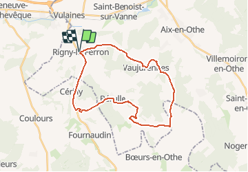
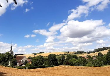
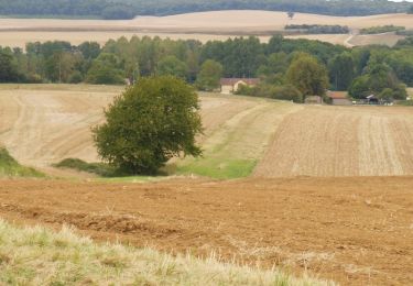
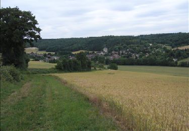
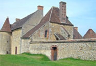
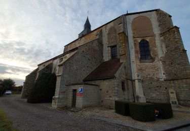
Randonnée Vélo de 28 km à découvrir à Grand Est, Aube, Rigny-le-Ferron. Cette randonnée est proposée par tracegps.
Description
Circuit proposé par l'office de Tourisme du Pays d'Othe, vallée de la Vanne et le Cyclo Club Othéen. Départ de la place de la mairie de Rigny-le-Ferron. Retrouvez le circuit a télécharger sur le site de l'office de tourisme du Pays d'Othe, vallée de la Vanne.
Localisation
Pays :
France
Région :
Grand Est
Département/Province :
Aube
Commune :
Rigny-le-Ferron
Localité :
Unknown
Départ:(Dec)
Départ:(UTM)
546842 ; 5339674 (31U) N.
Commentaires
Randonnées à proximité
![Randonnée Marche Bérulle - Sentier du Fer - Bérulle - Photo](https://media.geolcdn.com/t/375/260/ext.jpg?maxdim=2&url=https%3A%2F%2Fservices.sitytrail.com%2FGeolivesWS%2FDownloadMedia.ashx%3FTrailID%3D111397%26Media%3D7114_4.jpg)
![Marche Marche](https://static1.geolcdn.com/sitytour/trail-icons/101.png)
Sentier du Fer - Bérulle
Marche
Facile
(1)
Bérulle,
Grand Est,
Aube,
France
![](/images/other/stat-length.png)
5,8 km | 7,9 km-effort
1h 30min
![](https://static1.geolcdn.com/siteimages/upload/files/16400158638029165_repeat_loop_refresh_sync_direction_icon.png)
Oui
![Randonnée Vélo électrique Rigny-le-Ferron - Randonnée Rigny le Ferron-Cérilly-Bois le roi - Photo](https://media.geolcdn.com/t/375/260/ext.jpg?maxdim=2&url=https%3A%2F%2Fmedia.geolcdn.com%2Ff%2F4ea76414-e4be-42a2-ad41-7a84e4914579.jpg)
![Vélo électrique Vélo électrique](https://static1.geolcdn.com/sitytour/trail-icons/205.png)
Randonnée Rigny le Ferron-Cérilly-Bois le roi
Vélo électrique
Difficile
Rigny-le-Ferron,
Grand Est,
Aube,
France
![](/images/other/stat-length.png)
24 km | 31 km-effort
3h 39min
![](https://static1.geolcdn.com/siteimages/upload/files/16400158638029165_repeat_loop_refresh_sync_direction_icon.png)
Oui
![Randonnée Marche Bérulle - bérulle - Photo](https://media.geolcdn.com/t/375/260/ext.jpg?maxdim=2&url=https%3A%2F%2Fmedia.geolcdn.com%2Ff%2Fe8c41450-29be-4479-814c-c124a8438ec7.jpg)
![Marche Marche](https://static1.geolcdn.com/sitytour/trail-icons/101.png)
![Randonnée Marche Flacy - Autour de Flacy - Photo](https://media.geolcdn.com/t/375/260/ext.jpg?maxdim=2&url=https%3A%2F%2Fservices.sitytrail.com%2FGeolivesWS%2FDownloadMedia.ashx%3FTrailID%3D172803%26Media%3D14233_6.jpg)
![Marche Marche](https://static1.geolcdn.com/sitytour/trail-icons/101.png)
Autour de Flacy
Marche
Moyen
Flacy,
Bourgogne-Franche-Comté,
Yonne,
France
![](/images/other/stat-length.png)
11,5 km | 13,4 km-effort
3h 0min
![](https://static1.geolcdn.com/siteimages/upload/files/16400158638029165_repeat_loop_refresh_sync_direction_icon.png)
Oui
![Randonnée Marche Bérulle - Bérulle Bérulle : Circuit de la Chapelle Sainte-Reine: Circuit de la Chapelle Sainte-Reine - Photo](https://media.geolcdn.com/t/375/260/ext.jpg?maxdim=2&url=https%3A%2F%2Fservices.sitytrail.com%2FGeolivesWS%2FDownloadMedia.ashx%3FTrailID%3D155976%26Media%3D6d104592-9a15-40d5-b2fe-77d39b9154de.JPG)
![Marche Marche](https://static1.geolcdn.com/sitytour/trail-icons/101.png)
Bérulle Bérulle : Circuit de la Chapelle Sainte-Reine: Circuit de la Chapelle...
Marche
Moyen
Bérulle,
Grand Est,
Aube,
France
![](/images/other/stat-length.png)
13,2 km | 16,4 km-effort
4h 0min
![](https://static1.geolcdn.com/siteimages/upload/files/16400158638029165_repeat_loop_refresh_sync_direction_icon.png)
Oui
![Randonnée Marche Paisy-Cosdon - Vaujurennes - Bérulle (Boucle) 2011 - Photo](https://media.geolcdn.com/t/375/260/ext.jpg?maxdim=2&url=https%3A%2F%2Fservices.sitytrail.com%2FGeolivesWS%2FDownloadMedia.ashx%3FTrailID%3D152737%26Media%3D61315afe-d38a-4173-bfb9-c391c7bdfadb.JPG)
![Marche Marche](https://static1.geolcdn.com/sitytour/trail-icons/101.png)
Vaujurennes - Bérulle (Boucle) 2011
Marche
Facile
Paisy-Cosdon,
Grand Est,
Aube,
France
![](/images/other/stat-length.png)
12,9 km | 15,2 km-effort
4h 0min
![](https://static1.geolcdn.com/siteimages/upload/files/16400158638029165_repeat_loop_refresh_sync_direction_icon.png)
Oui
![Randonnée Marche Rigny-le-Ferron - Promenade des Sources - Rigny le Ferron - Photo](https://media.geolcdn.com/t/375/260/ext.jpg?maxdim=2&url=https%3A%2F%2Fservices.sitytrail.com%2FGeolivesWS%2FDownloadMedia.ashx%3FTrailID%3D111315%26Media%3D6988_5.jpg)
![Marche Marche](https://static1.geolcdn.com/sitytour/trail-icons/101.png)
Promenade des Sources - Rigny le Ferron
Marche
Difficile
Rigny-le-Ferron,
Grand Est,
Aube,
France
![](/images/other/stat-length.png)
14,8 km | 19 km-effort
3h 45min
![](https://static1.geolcdn.com/siteimages/upload/files/16400158638029165_repeat_loop_refresh_sync_direction_icon.png)
Oui
![Randonnée Marche Bérulle - Circuit de la chapelle Sainte-Reine - Bérulle - Photo](https://media.geolcdn.com/t/375/260/ext.jpg?maxdim=2&url=https%3A%2F%2Fservices.sitytrail.com%2FGeolivesWS%2FDownloadMedia.ashx%3FTrailID%3D111241%26Media%3D6794_3.jpg)
![Marche Marche](https://static1.geolcdn.com/sitytour/trail-icons/101.png)
Circuit de la chapelle Sainte-Reine - Bérulle
Marche
Moyen
(1)
Bérulle,
Grand Est,
Aube,
France
![](/images/other/stat-length.png)
11 km | 14 km-effort
2h 45min
![](https://static1.geolcdn.com/siteimages/upload/files/16400158638029165_repeat_loop_refresh_sync_direction_icon.png)
Oui
![Randonnée Marche Coulours - Couleurs rando jc - Photo](https://media.geolcdn.com/t/375/260/ext.jpg?maxdim=2&url=https%3A%2F%2Fmedia.geolcdn.com%2Ff%2F1f806a94-2583-4bd9-b7b1-2d1cde138c1e.jpg)
![Marche Marche](https://static1.geolcdn.com/sitytour/trail-icons/101.png)
Couleurs rando jc
Marche
Très difficile
Coulours,
Bourgogne-Franche-Comté,
Yonne,
France
![](/images/other/stat-length.png)
15,8 km | 19,1 km-effort
7h 51min
![](https://static1.geolcdn.com/siteimages/upload/files/16400158638029165_repeat_loop_refresh_sync_direction_icon.png)
Non