![](/images/other/stat-length.png)
![Randonnée Marche Ramecourt - Sentier Ste-Menne - Ramecourt - Photo](https://media.geolcdn.com/t/1900/400/ext.pjpeg?maxdim=2&url=https%3A%2F%2Fservices.sitytrail.com%2FGeolivesWS%2FDownloadMedia.ashx%3FTrailID%3D112757%26Media%3D12061_5.jpg)
Sentier Ste-Menne - Ramecourt
tracegps
Utilisateur
![Longueur](/images/other/stat-length.png)
![Altitude max](https://static1.geolcdn.com/siteimages/upload/files/1508320355ic_sort_altitude_max_24dp.png)
![Dénivelé positif](https://static1.geolcdn.com/siteimages/upload/files/1508320355ic_sort_den_pos_24dp.png)
![Km-Effort](/images/other/stat-length.png)
![Altitude min](https://static1.geolcdn.com/siteimages/upload/files/1508320355ic_sort_altitude_min_24dp.png)
![Dénivelé négatif](https://static1.geolcdn.com/siteimages/upload/files/1508320355ic_sort_den_neg_24dp.png)
![Boucle](https://static1.geolcdn.com/siteimages/upload/files/16400158638029165_repeat_loop_refresh_sync_direction_icon.png)
![Marche](https://static1.geolcdn.com/sitytour/trail-icons/101.png)
2h40
Difficulté : Moyen
![Scannez ce code QR pour ouvrir la randonnée dans l'application SityTrail](https://capi.geolives.com/qq0zvz2zws4bq2lad0pu/sitytour/trails/112757/qr.png?size=200)
Application GPS de randonnée GRATUITE
À propos
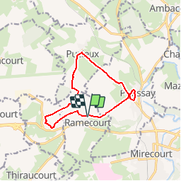
Randonnée Marche de 10,6 km à découvrir à Grand Est, Vosges, Ramecourt. Cette randonnée est proposée par tracegps.
Description
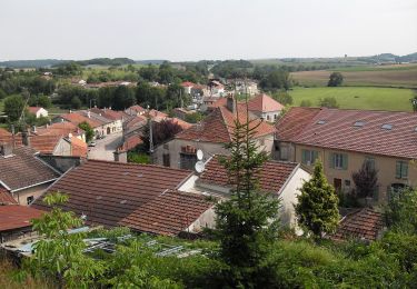
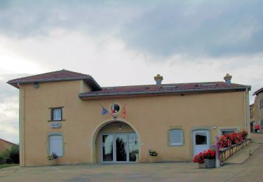
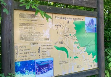
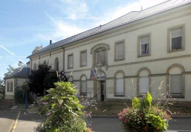
Circuit proposé par la communauté de communes de Mirecourt . C’est un itinéraire en boucle, d'environ 12 km, basé sur la composante du patrimoine. Une série de panneaux didactiques jalonne le parcours. Départ de la rue de Rémifontaine à Ramecourt. Retrouvez les circuits de la communauté de communes de Mirecourt sur leur site.
Localisation
Commentaires
Randonnées à proximité
![Randonnée A pied Mirecourt - Sentier des Écoliers - Photo](https://media.geolcdn.com/t/375/260/37a85499-65f3-411c-b514-fd76b1c94f58.jpeg&format=jpg&maxdim=2)
![A pied A pied](https://static1.geolcdn.com/sitytour/trail-icons/100.png)
A pied
![](/images/other/stat-length.png)
![](https://static1.geolcdn.com/siteimages/upload/files/16400158638029165_repeat_loop_refresh_sync_direction_icon.png)
![Randonnée A pied Mazirot - Sentier des Trois Fontaines - Photo](https://media.geolcdn.com/t/375/260/3195c67f-6fc7-4a51-b3fc-afb10c20cd4c.jpeg&format=jpg&maxdim=2)
![A pied A pied](https://static1.geolcdn.com/sitytour/trail-icons/100.png)
A pied
![](/images/other/stat-length.png)
![](https://static1.geolcdn.com/siteimages/upload/files/16400158638029165_repeat_loop_refresh_sync_direction_icon.png)
![Randonnée A pied Domvallier - Sentier Victor Hugo - Photo](https://media.geolcdn.com/t/375/260/847969bb-b882-4d7a-93e4-f8a52a5951e6.jpeg&format=jpg&maxdim=2)
![A pied A pied](https://static1.geolcdn.com/sitytour/trail-icons/100.png)
A pied
![](/images/other/stat-length.png)
![](https://static1.geolcdn.com/siteimages/upload/files/16400158638029165_repeat_loop_refresh_sync_direction_icon.png)
![Randonnée A pied Mirecourt - Sentier des Luthiers et des Dentellières - Photo](https://media.geolcdn.com/t/375/260/224ec8ee-02f7-4835-910b-c43f2bba21e0.jpeg&format=jpg&maxdim=2)
![A pied A pied](https://static1.geolcdn.com/sitytour/trail-icons/100.png)
A pied
![](/images/other/stat-length.png)
![](https://static1.geolcdn.com/siteimages/upload/files/16400158638029165_repeat_loop_refresh_sync_direction_icon.png)
![Randonnée A pied Puzieux - Sentier Sainte-Menne - Photo](https://media.geolcdn.com/t/375/260/d09aae78-2027-4ee8-af6c-352934fc41fe.jpeg&format=jpg&maxdim=2)
![A pied A pied](https://static1.geolcdn.com/sitytour/trail-icons/100.png)
A pied
![](/images/other/stat-length.png)
![](https://static1.geolcdn.com/siteimages/upload/files/16400158638029165_repeat_loop_refresh_sync_direction_icon.png)
![Randonnée A pied Ambacourt - Jonction Ambacourt-Mazirot - Photo](https://media.geolcdn.com/t/375/260/a7a5f7aa-9c3b-49ab-a3ba-0cb86aa90645.jpeg&format=jpg&maxdim=2)
![A pied A pied](https://static1.geolcdn.com/sitytour/trail-icons/100.png)
A pied
![](/images/other/stat-length.png)
![](https://static1.geolcdn.com/siteimages/upload/files/16400158638029165_repeat_loop_refresh_sync_direction_icon.png)
![Randonnée A pied Ambacourt - Jonction Ambacourt-Puzieux - Photo](https://media.geolcdn.com/t/375/260/a7a5f7aa-9c3b-49ab-a3ba-0cb86aa90645.jpeg&format=jpg&maxdim=2)
![A pied A pied](https://static1.geolcdn.com/sitytour/trail-icons/100.png)
A pied
![](/images/other/stat-length.png)
![](https://static1.geolcdn.com/siteimages/upload/files/16400158638029165_repeat_loop_refresh_sync_direction_icon.png)
![Randonnée sport Mazirot - Sentier des 3 fontaines - Photo](https://media.geolcdn.com/t/375/260/7a6b2516-fa41-4a74-82f6-03130015cbc5.jpg&format=jpg&maxdim=2)
sport
![](/images/other/stat-length.png)
![](https://static1.geolcdn.com/siteimages/upload/files/16400158638029165_repeat_loop_refresh_sync_direction_icon.png)
![Randonnée A pied Mattaincourt - Sentier du bois de Malaumont - Photo](https://media.geolcdn.com/t/375/260/881a2747-b482-491a-9e7a-bbf923a2a0ab.jpeg&format=jpg&maxdim=2)
![A pied A pied](https://static1.geolcdn.com/sitytour/trail-icons/100.png)
A pied
![](/images/other/stat-length.png)
![](https://static1.geolcdn.com/siteimages/upload/files/16400158638029165_repeat_loop_refresh_sync_direction_icon.png)