![](/images/other/stat-length.png)
![Randonnée Marche Beaufort - Le Bersend - Le berceau d'Arêches - Photo](https://media.geolcdn.com/t/1900/400/ext.pjpeg?maxdim=2&url=https%3A%2F%2Fservices.sitytrail.com%2FGeolivesWS%2FDownloadMedia.ashx%3FTrailID%3D112689%26Media%3D11534_5.jpg)
Le Bersend - Le berceau d'Arêches
tracegps
Utilisateur
![Longueur](/images/other/stat-length.png)
![Altitude max](https://static1.geolcdn.com/siteimages/upload/files/1508320355ic_sort_altitude_max_24dp.png)
![Dénivelé positif](https://static1.geolcdn.com/siteimages/upload/files/1508320355ic_sort_den_pos_24dp.png)
![Km-Effort](/images/other/stat-length.png)
![Altitude min](https://static1.geolcdn.com/siteimages/upload/files/1508320355ic_sort_altitude_min_24dp.png)
![Dénivelé négatif](https://static1.geolcdn.com/siteimages/upload/files/1508320355ic_sort_den_neg_24dp.png)
![Boucle](https://static1.geolcdn.com/siteimages/upload/files/16400158638029165_repeat_loop_refresh_sync_direction_icon.png)
![Marche](https://static1.geolcdn.com/sitytour/trail-icons/101.png)
2h30
Difficulté : Moyen
![Scannez ce code QR pour ouvrir la randonnée dans l'application SityTrail](https://capi.geolives.com/qq0zvz2zws4bq2lad0pu/sitytour/trails/112689/qr.png?size=200)
Application GPS de randonnée GRATUITE
À propos
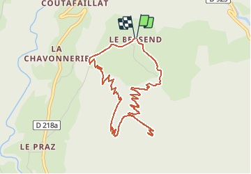
Randonnée Marche de 5,1 km à découvrir à Auvergne-Rhône-Alpes, Savoie, Beaufort. Cette randonnée est proposée par tracegps.
Description
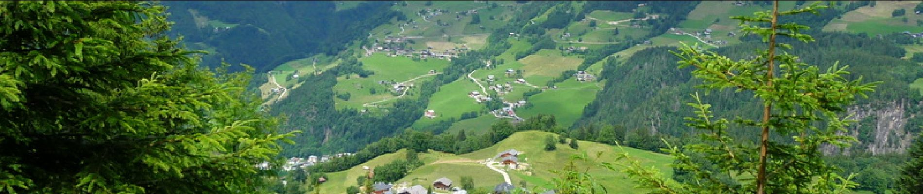
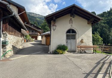
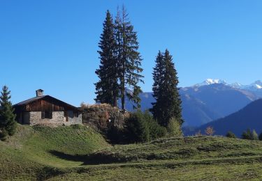
Le Bersend, départ de notre randonnée, est installé sur un verrou glaciaire et surplombe Beaufort de 400 mètres, dominant la vallée du Doron. Caractéristique des hameaux qui autrefois vivaient en autarcie pendant les longs hivers, la vie s'organisait autour de la chapelle, construite en 1624. Le four à pain communal pouvait contenir 42 pains de 3 à 4 kg chacun. On cuisait le pain tous les 2 à 3 mois jusque dans les années 60 ; il sert encore aujourd'hui pour les fêtes. Le bassin, "bachal" en patois, est l'endroit où l’on menait boire les vaches 2 fois par jour. La forêt du Bersend, lieu de notre randonnée, fait partie d’une des trois réserves de chasse communales. Le chamois, le chevreuil, le lièvre y sont présents. Le chamois fait l’objet de comptages réguliers effectués par les gardes chasse de l’ONF et de la Fédération de chasse. A l’époque du rut, en octobre / novembre, le comptage permet de déterminer la structure des populations (mâles, femelles, jeunes). En juin, il permettra d’estimer l’indice de reproduction. Départ : Le Bersend
Localisation
Commentaires
Randonnées à proximité
![Randonnée Vélo Villard-sur-Doron - Boucle Villars le Mont Crest Voland Les Saisies - Photo](https://media.geolcdn.com/t/375/260/ext.jpg?maxdim=2&url=https%3A%2F%2Fservices.sitytrail.com%2FGeolivesWS%2FDownloadMedia.ashx%3FTrailID%3D855162%26Media%3D20171031161248.jpg)
![Vélo Vélo](https://static1.geolcdn.com/sitytour/trail-icons/200.png)
Vélo
![](/images/other/stat-length.png)
![](https://static1.geolcdn.com/siteimages/upload/files/16400158638029165_repeat_loop_refresh_sync_direction_icon.png)
![Randonnée Marche Beaufort - D'Arêches au Col de Pré par le hameau de Boudin - Photo](https://media.geolcdn.com/t/375/260/ext.jpg?maxdim=2&url=https%3A%2F%2Fservices.sitytrail.com%2FGeolivesWS%2FDownloadMedia.ashx%3FTrailID%3D112688%26Media%3D11533_5.jpg)
![Marche Marche](https://static1.geolcdn.com/sitytour/trail-icons/101.png)
Marche
![](/images/other/stat-length.png)
![](https://static1.geolcdn.com/siteimages/upload/files/16400158638029165_repeat_loop_refresh_sync_direction_icon.png)
![Randonnée Ski de randonnée Beaufort - Anticime de la pointe de la grande journée, montée couloir du grepets - Photo](https://media.geolcdn.com/t/375/260/8dfd1937-3bd4-42bd-a4fa-284d4bb8802e.jpg&format=jpg&maxdim=2)
![Ski de randonnée Ski de randonnée](https://static1.geolcdn.com/sitytour/trail-icons/503.png)
Ski de randonnée
![](/images/other/stat-length.png)
![](https://static1.geolcdn.com/siteimages/upload/files/16400158638029165_repeat_loop_refresh_sync_direction_icon.png)
![Randonnée Ski de randonnée Beaufort - Côte 2000 et col de Roche plane - Photo](https://media.geolcdn.com/t/375/260/38a11e49-5450-4382-89d2-44ae6ea43162.jpg&format=jpg&maxdim=2)
![Ski de randonnée Ski de randonnée](https://static1.geolcdn.com/sitytour/trail-icons/503.png)
Ski de randonnée
![](/images/other/stat-length.png)
![](https://static1.geolcdn.com/siteimages/upload/files/16400158638029165_repeat_loop_refresh_sync_direction_icon.png)
![Randonnée Marche Hauteluce - Hauteluce - Photo](https://media.geolcdn.com/t/375/260/ext.jpg?maxdim=2&url=https%3A%2F%2Fstatic1.geolcdn.com%2Fsiteimages%2Fupload%2Ffiles%2F1553511878bg_sport_marche.png)
![Marche Marche](https://static1.geolcdn.com/sitytour/trail-icons/101.png)
Marche
![](/images/other/stat-length.png)
![](https://static1.geolcdn.com/siteimages/upload/files/16400158638029165_repeat_loop_refresh_sync_direction_icon.png)
![Randonnée Marche Beaufort - Le pas de l’âne 10 km 850 m dénivelé + - Photo](https://media.geolcdn.com/t/375/260/e16223c0-d24b-4318-beff-cfc74b9fa02c.jpg&format=jpg&maxdim=2)
![Marche Marche](https://static1.geolcdn.com/sitytour/trail-icons/101.png)
Marche
![](/images/other/stat-length.png)
![](https://static1.geolcdn.com/siteimages/upload/files/16400158638029165_repeat_loop_refresh_sync_direction_icon.png)
![Randonnée Marche Beaufort - Roche Pastrire 8,7 km - Photo](https://media.geolcdn.com/t/375/260/783675ed-dc1c-4b41-82f9-ac57164bc294.jpg&format=jpg&maxdim=2)
![Marche Marche](https://static1.geolcdn.com/sitytour/trail-icons/101.png)
Marche
![](/images/other/stat-length.png)
![](https://static1.geolcdn.com/siteimages/upload/files/16400158638029165_repeat_loop_refresh_sync_direction_icon.png)
![Randonnée Marche Beaufort - Areches col du Pré version 11 km - Photo](https://media.geolcdn.com/t/375/260/7abc590a-8c82-46ce-b467-d226a059a885.jpg&format=jpg&maxdim=2)
![Marche Marche](https://static1.geolcdn.com/sitytour/trail-icons/101.png)
Marche
![](/images/other/stat-length.png)
![](https://static1.geolcdn.com/siteimages/upload/files/16400158638029165_repeat_loop_refresh_sync_direction_icon.png)
![Randonnée Marche Beaufort - Col de Roche Plane - Photo](https://media.geolcdn.com/t/375/260/73cc5e19-0c97-48f8-b76a-023f89d535d0.jpg&format=jpg&maxdim=2)
![Marche Marche](https://static1.geolcdn.com/sitytour/trail-icons/101.png)
Marche
![](/images/other/stat-length.png)
![](https://static1.geolcdn.com/siteimages/upload/files/16400158638029165_repeat_loop_refresh_sync_direction_icon.png)