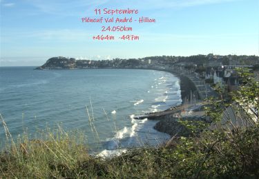
![](/images/other/stat-length.png)
![Randonnée Marche Saint-Alban - A la rencontre de la Flora - Saint Alban - Photo](https://media.geolcdn.com/t/1900/400/ext.pjpeg?maxdim=2&url=https%3A%2F%2Fservices.sitytrail.com%2FGeolivesWS%2FDownloadMedia.ashx%3FTrailID%3D112673%26Media%3D11455_5.jpg)
A la rencontre de la Flora - Saint Alban
tracegps
Utilisateur
![Longueur](/images/other/stat-length.png)
![Altitude max](https://static1.geolcdn.com/siteimages/upload/files/1508320355ic_sort_altitude_max_24dp.png)
![Dénivelé positif](https://static1.geolcdn.com/siteimages/upload/files/1508320355ic_sort_den_pos_24dp.png)
![Km-Effort](/images/other/stat-length.png)
![Altitude min](https://static1.geolcdn.com/siteimages/upload/files/1508320355ic_sort_altitude_min_24dp.png)
![Dénivelé négatif](https://static1.geolcdn.com/siteimages/upload/files/1508320355ic_sort_den_neg_24dp.png)
![Boucle](https://static1.geolcdn.com/siteimages/upload/files/16400158638029165_repeat_loop_refresh_sync_direction_icon.png)
![Marche](https://static1.geolcdn.com/sitytour/trail-icons/101.png)
2h30
Difficulté : Moyen
![Scannez ce code QR pour ouvrir la randonnée dans l'application SityTrail](https://capi.geolives.com/qq0zvz2zws4bq2lad0pu/sitytour/trails/112673/qr.png?size=200)
Application GPS de randonnée GRATUITE
À propos
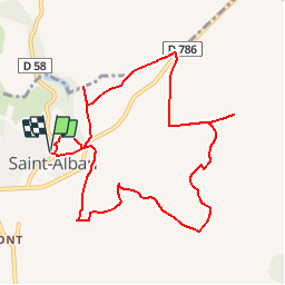
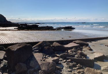
Randonnée Marche de 10 km à découvrir à Bretagne, Côtes-d'Armor, Saint-Alban. Cette randonnée est proposée par tracegps.
Description
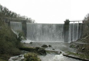
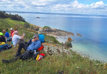
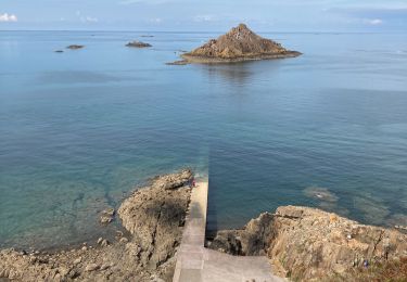
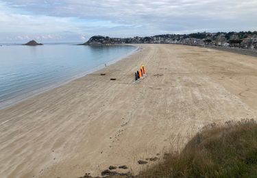
Une trentaine de communes portent le label "Communes du Patrimoine Rural de Bretagne" et mettent en commun leur volonté de sauvegarde, de mise en valeur et d'animation de leur patrimoine architectural et paysager. Des circuits de randonnées pour les uns, des balades champêtres pour les autres vous feront découvrir les bourgs et les villages de caractère de nos communes. Saint Alban, carrefour du Pays de Lamballe et de la Côte de Penthièvre est à quelques pas de la mer. Commune remarquable par son bourg perché, entouré d'un écrin de verdure formé par la Vallée de la Flora, elle a su conserver son caractère d'authenticité, mettre en valeur ses sites classés et perpétrer ses fêtes traditionnelles. Départ de l'église de Saint-Alban. Retrouvez la fiche du circuit sur le site des Communes du Patrimoine Rural de Bretagne.
Localisation
Commentaires
Randonnées à proximité
![Randonnée Marche Pléneuf-Val-André - N°11 GR34 Pléneuf Val André -- Hillion - Photo](https://media.geolcdn.com/t/375/260/a7664a50-bf36-435d-8dd9-5d811f168a14.jpg&format=jpg&maxdim=2)
![Marche Marche](https://static1.geolcdn.com/sitytour/trail-icons/101.png)
Marche
![](/images/other/stat-length.png)
![](https://static1.geolcdn.com/siteimages/upload/files/16400158638029165_repeat_loop_refresh_sync_direction_icon.png)
![Randonnée Marche Pléneuf-Val-André - GR_34_CA_14_Pleneuf-Val-Andre_Lamballe_20230820 - Photo](https://media.geolcdn.com/t/375/260/dc9169ae-5d20-486b-b60a-ec7c033f0c7b.jpg&format=jpg&maxdim=2)
![Marche Marche](https://static1.geolcdn.com/sitytour/trail-icons/101.png)
Marche
![](/images/other/stat-length.png)
![](https://static1.geolcdn.com/siteimages/upload/files/16400158638029165_repeat_loop_refresh_sync_direction_icon.png)
![Randonnée Marche Lamballe-Armor - La Côte du Port Morvan 6.7.23 - Photo](https://media.geolcdn.com/t/375/260/8311d318-82e2-44fd-9871-c2f1c72b6002.jpg&format=jpg&maxdim=2)
![Marche Marche](https://static1.geolcdn.com/sitytour/trail-icons/101.png)
Marche
![](/images/other/stat-length.png)
![](https://static1.geolcdn.com/siteimages/upload/files/16400158638029165_repeat_loop_refresh_sync_direction_icon.png)
![Randonnée Marche Lamballe-Armor - Planguenoual - GR34 - 1 - Photo](https://media.geolcdn.com/t/375/260/ext.jpg?maxdim=2&url=https%3A%2F%2Fservices.sitytrail.com%2FGeolivesWS%2FDownloadMedia.ashx%3FTrailID%3D301797%26Media%3Dbdaa7ae5-5900-4d86-b97c-0d1afc4379c1.jpg)
![Marche Marche](https://static1.geolcdn.com/sitytour/trail-icons/101.png)
Marche
![](/images/other/stat-length.png)
![](https://static1.geolcdn.com/siteimages/upload/files/16400158638029165_repeat_loop_refresh_sync_direction_icon.png)
![Randonnée Marche Pléneuf-Val-André - dahouet - Photo](https://media.geolcdn.com/t/375/260/15fe32ae-cb04-4ac1-8080-bb10a1b960da.jpg&format=jpg&maxdim=2)
![Marche Marche](https://static1.geolcdn.com/sitytour/trail-icons/101.png)
Marche
![](/images/other/stat-length.png)
![](https://static1.geolcdn.com/siteimages/upload/files/16400158638029165_repeat_loop_refresh_sync_direction_icon.png)
![Randonnée Marche Pléneuf-Val-André - Pleneuf Val André - Photo](https://media.geolcdn.com/t/375/260/845eb97f-436b-4324-bb70-14b51579c59e.jpg&format=jpg&maxdim=2)
![Marche Marche](https://static1.geolcdn.com/sitytour/trail-icons/101.png)
Marche
![](/images/other/stat-length.png)
![](https://static1.geolcdn.com/siteimages/upload/files/16400158638029165_repeat_loop_refresh_sync_direction_icon.png)
![Randonnée Marche Pléneuf-Val-André - Dahouet - Photo](https://media.geolcdn.com/t/375/260/0f240a74-0928-471b-9079-268af701de39.jpg&format=jpg&maxdim=2)
![Marche Marche](https://static1.geolcdn.com/sitytour/trail-icons/101.png)
Marche
![](/images/other/stat-length.png)
![](https://static1.geolcdn.com/siteimages/upload/files/16400158638029165_repeat_loop_refresh_sync_direction_icon.png)
![Randonnée Marche Lamballe-Armor - Planguenouan - Photo](https://media.geolcdn.com/t/375/260/c8ac0864-9c49-43bb-8972-2ec0fd1097e5.jpg&format=jpg&maxdim=2)
![Marche Marche](https://static1.geolcdn.com/sitytour/trail-icons/101.png)
Marche
![](/images/other/stat-length.png)
![](https://static1.geolcdn.com/siteimages/upload/files/16400158638029165_repeat_loop_refresh_sync_direction_icon.png)
![Randonnée Marche Lamballe-Armor - GR 34 Etape 11 Morieux Saint Brieuc 22-10-2020 - Photo](https://media.geolcdn.com/t/375/260/ext.jpg?maxdim=2&url=https%3A%2F%2Fstatic1.geolcdn.com%2Fsiteimages%2Fupload%2Ffiles%2F1553511878bg_sport_marche.png)
![Marche Marche](https://static1.geolcdn.com/sitytour/trail-icons/101.png)
Marche
![](/images/other/stat-length.png)
![](https://static1.geolcdn.com/siteimages/upload/files/16400158638029165_repeat_loop_refresh_sync_direction_icon.png)